


Physical Scientist James Romano (UMid WSC, left) and Field Assistant Justin Peschman (UMid WSC, right) collect a sediment core from the Scuppernong River near Palmyra, Wisconsin. https://waterdata.usgs.gov/monitoring-location/05426400
Hayley T Olds
Hayley Olds is a Hydrologist with the Upper Midwest Water Science Center in Wisconsin, where she has worked since 2012.
Hayley Olds is stationed in Milwaukee, Wisconsin. Her research has focused on freshwater quality assessments using both freshwater organisms and molecular source tracking. Hayley has experience with monitoring harmful algal blooms (HABs) composition, toxicity, and spatial extent using low-cost sampling techiques such as Solid Phase Adsorption Toxin Tracking (SPATT) technology throughout the Upper Midwest and Northeast regions, and nation-wide at National Parks throughout the country. Hayley also has experience in assessing benthic invertebrate, phytoplankton, and zooplankton communities, as well as sediment contamination and toxicity, in rivers and streams throughout Wisconsin, including several of Wisconsin’s Lake Michigan Areas of Concern. Over her career, Hayley has been involved in collecting and analyzing ecological data, including algae, invertebrates, fish, sediment, and surveying habitat at a local scale in southeastern Wisconsin's tributaries to Lake Michigan, as well as nationally in the Pacific Northwest, Northeast, and California regions.
Science and Products
Integrated Ecosystems Studies Team
The Integrated Ecosystem Studies Team (IES) at the Upper Midwest Water Science Center uses interdisciplinary approaches to investigate characteristics and drivers of water quality and aquatic biology in rivers, lakes, and wetlands.
MMSD Watercourse Corridor Study: Ecological Assessments and Trends
Changes in streams that result from urban development such as loss of stream habitat, inadequate or flashy streamflow, and degraded water quality can adversely affect communities of aquatic organisms. MMSD Watercourse Corridor Study ecological assessments evaluate water quality over time by pairing community assessments of aquatic organisms with chemical assessments from passive samplers, as well...

Two scientists collect a sediment core from the Scuppernong River near Palmyra, Wisconsin
Physical Scientist James Romano (UMid WSC, left) and Field Assistant Justin Peschman (UMid WSC, right) collect a sediment core from the Scuppernong River near Palmyra, Wisconsin. https://waterdata.usgs.gov/monitoring-location/05426400

Two scientists collect a sediment core from the Mukwonago River at Mukwonago, Wisconsin
Biologist Pat Perner (USGS Upper Midwest Environmental Science Center, left) and Physical Scientist James Romano (UMid WSC, right) collect a sediment core from the Mukwonago River at Mukwonago, Wisconsin. https://waterdata.usgs.gov/monitoring-location/05544200/
Biologist Pat Perner (USGS Upper Midwest Environmental Science Center, left) and Physical Scientist James Romano (UMid WSC, right) collect a sediment core from the Mukwonago River at Mukwonago, Wisconsin. https://waterdata.usgs.gov/monitoring-location/05544200/

Two scientists collect a sediment core from the Root River at Grange Avenue in Greenfield, Wisconsin
linkBiologist Pat Perner (USGS Upper Midwest Environmental Science Center, left) and Field Assistant Justin Peschman (UMid WSC, right) collect a sediment core from the Root River at Grange Avenue in Greenfield, Wisconsin. https://waterdata.usgs.gov/monitoring-location/04087214/

Scientist filters a water sample in the field for nutrient analysis
Field Assistant Justin Peschman (UMid WSC) filters a water sample for nutrient analysis at Mukwonago River at Mukwonago, Wisconsin. https://waterdata.usgs.gov/monitoring-location/05544200/
Field Assistant Justin Peschman (UMid WSC) filters a water sample for nutrient analysis at Mukwonago River at Mukwonago, Wisconsin. https://waterdata.usgs.gov/monitoring-location/05544200/
Habitat sampling at Underwood Creek at Wauwatosa, Wisconsin
Habitat sampling at a restored reach at Underwood Creek at Wauwatosa, Wisconsin. https://waterdata.usgs.gov/monitoring-location/04087088/
Habitat sampling at a restored reach at Underwood Creek at Wauwatosa, Wisconsin. https://waterdata.usgs.gov/monitoring-location/04087088/

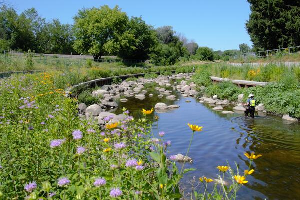
A restored section of Underwood Creek at Wauwatosa, Wisconsin
A restored section of Underwood Creek at Wauwatosa, Wisconsin. https://waterdata.usgs.gov/monitoring-location/04087088/
A restored section of Underwood Creek at Wauwatosa, Wisconsin. https://waterdata.usgs.gov/monitoring-location/04087088/
Fish shocking with backpack shocker at Underwood Creek at Wauwatosa, Wisconsin
USGS scientists electrofishing with a backpack shocker at Underwood Creek at Wauwatosa, Wisconsin. https://waterdata.usgs.gov/monitoring-location/04087088/.
USGS scientists electrofishing with a backpack shocker at Underwood Creek at Wauwatosa, Wisconsin. https://waterdata.usgs.gov/monitoring-location/04087088/.
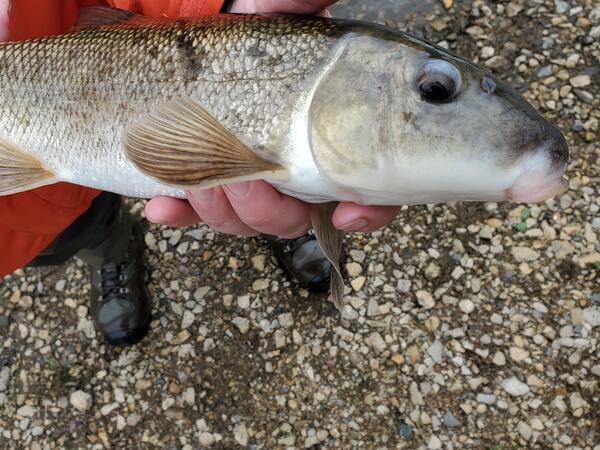
Scientist holding a white sucker fish caught in Underwood Creek at Wauwatosa, Wisconsin
USGS scientist holding a white sucker fish caught in Underwood Creek at Wauwatosa, Wisconsin. https://waterdata.usgs.gov/monitoring-location/04087088/
USGS scientist holding a white sucker fish caught in Underwood Creek at Wauwatosa, Wisconsin. https://waterdata.usgs.gov/monitoring-location/04087088/
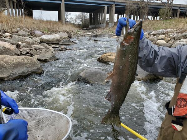
A milting rainbow trout caught in Underwood Creek at Wauwatosa, Wisconsin
USGS scientist holding a milting rainbow trout caught as part of an assessment of fish passage in Underwood Creek at Wauwatosa, Wisconsin, just downstream of I-41/US 45. https://waterdata.usgs.gov/monitoring-location/04087088/
USGS scientist holding a milting rainbow trout caught as part of an assessment of fish passage in Underwood Creek at Wauwatosa, Wisconsin, just downstream of I-41/US 45. https://waterdata.usgs.gov/monitoring-location/04087088/

Rainbow trout in net
Rainbow trout caught in net in Underwood Creek at Wauwatosa, Wisconsin. https://waterdata.usgs.gov/monitoring-location/04087088/
Rainbow trout caught in net in Underwood Creek at Wauwatosa, Wisconsin. https://waterdata.usgs.gov/monitoring-location/04087088/

Breeding male central stoneroller fish
USGS scientist holding a male central stoneroller caught in Underwood Creek at Wauwatosa, Wisconsin. https://waterdata.usgs.gov/monitoring-location/04087088/. This fish is native to Wisconsin; the tubercles (bumps) on its head indicate that it is spawning.
USGS scientist holding a male central stoneroller caught in Underwood Creek at Wauwatosa, Wisconsin. https://waterdata.usgs.gov/monitoring-location/04087088/. This fish is native to Wisconsin; the tubercles (bumps) on its head indicate that it is spawning.

Algal sampling after removal of subsample
Close-up view of defined area of a rock cobble (middle) where attached algae and other material were removed with a brush. Rocks from multiple locations at a site are composited into a single sample representing the stream site.
Close-up view of defined area of a rock cobble (middle) where attached algae and other material were removed with a brush. Rocks from multiple locations at a site are composited into a single sample representing the stream site.

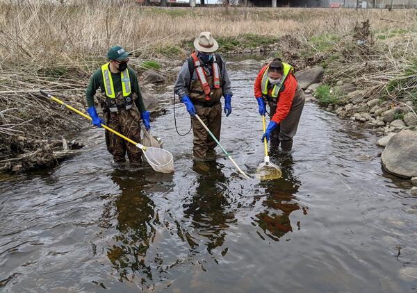
Invertebrate sampling
USGS scientist collecting one of five subsamples of aquatic invertebrates from a stream riffle by removing invertebrates from a defined area and collecting them with a Surber net. Each subsample is transferred to a bucket for compositing into a single sample for the site.
USGS scientist collecting one of five subsamples of aquatic invertebrates from a stream riffle by removing invertebrates from a defined area and collecting them with a Surber net. Each subsample is transferred to a bucket for compositing into a single sample for the site.

Invertebrate sampling closeup
Close up-view of defined area of the stream bottom where attached invertebrates are removed with a brush and washed into the Surber net; where possible, a hand rake is also used to dislodge organisms from shallow depths.
Close up-view of defined area of the stream bottom where attached invertebrates are removed with a brush and washed into the Surber net; where possible, a hand rake is also used to dislodge organisms from shallow depths.

Invertebrate sampling - sieving
After collection, invertebrates are washed through a series of sieves where large debris can be removed before being placed in the sample bottle.
After collection, invertebrates are washed through a series of sieves where large debris can be removed before being placed in the sample bottle.
Science and Products
- Science
Integrated Ecosystems Studies Team
The Integrated Ecosystem Studies Team (IES) at the Upper Midwest Water Science Center uses interdisciplinary approaches to investigate characteristics and drivers of water quality and aquatic biology in rivers, lakes, and wetlands.MMSD Watercourse Corridor Study: Ecological Assessments and Trends
Changes in streams that result from urban development such as loss of stream habitat, inadequate or flashy streamflow, and degraded water quality can adversely affect communities of aquatic organisms. MMSD Watercourse Corridor Study ecological assessments evaluate water quality over time by pairing community assessments of aquatic organisms with chemical assessments from passive samplers, as well... - Data
- Multimedia
Two scientists collect a sediment core from the Scuppernong River near Palmyra, Wisconsin
Physical Scientist James Romano (UMid WSC, left) and Field Assistant Justin Peschman (UMid WSC, right) collect a sediment core from the Scuppernong River near Palmyra, Wisconsin. https://waterdata.usgs.gov/monitoring-location/05426400
Physical Scientist James Romano (UMid WSC, left) and Field Assistant Justin Peschman (UMid WSC, right) collect a sediment core from the Scuppernong River near Palmyra, Wisconsin. https://waterdata.usgs.gov/monitoring-location/05426400
Two scientists collect a sediment core from the Mukwonago River at Mukwonago, WisconsinBiologist Pat Perner (USGS Upper Midwest Environmental Science Center, left) and Physical Scientist James Romano (UMid WSC, right) collect a sediment core from the Mukwonago River at Mukwonago, Wisconsin. https://waterdata.usgs.gov/monitoring-location/05544200/
Biologist Pat Perner (USGS Upper Midwest Environmental Science Center, left) and Physical Scientist James Romano (UMid WSC, right) collect a sediment core from the Mukwonago River at Mukwonago, Wisconsin. https://waterdata.usgs.gov/monitoring-location/05544200/
Two scientists collect a sediment core from the Root River at Grange Avenue in Greenfield, WisconsinTwo scientists collect a sediment core from the Root River at Grange Avenue in Greenfield, Wisconsin
linkBiologist Pat Perner (USGS Upper Midwest Environmental Science Center, left) and Field Assistant Justin Peschman (UMid WSC, right) collect a sediment core from the Root River at Grange Avenue in Greenfield, Wisconsin. https://waterdata.usgs.gov/monitoring-location/04087214/
Two scientists collect a sediment core from the Root River at Grange Avenue in Greenfield, Wisconsin
linkBiologist Pat Perner (USGS Upper Midwest Environmental Science Center, left) and Field Assistant Justin Peschman (UMid WSC, right) collect a sediment core from the Root River at Grange Avenue in Greenfield, Wisconsin. https://waterdata.usgs.gov/monitoring-location/04087214/
Scientist filters a water sample in the field for nutrient analysisField Assistant Justin Peschman (UMid WSC) filters a water sample for nutrient analysis at Mukwonago River at Mukwonago, Wisconsin. https://waterdata.usgs.gov/monitoring-location/05544200/
Field Assistant Justin Peschman (UMid WSC) filters a water sample for nutrient analysis at Mukwonago River at Mukwonago, Wisconsin. https://waterdata.usgs.gov/monitoring-location/05544200/
Habitat sampling at Underwood Creek at Wauwatosa, WisconsinHabitat sampling at a restored reach at Underwood Creek at Wauwatosa, Wisconsin. https://waterdata.usgs.gov/monitoring-location/04087088/
Habitat sampling at a restored reach at Underwood Creek at Wauwatosa, Wisconsin. https://waterdata.usgs.gov/monitoring-location/04087088/
A restored section of Underwood Creek at Wauwatosa, WisconsinA restored section of Underwood Creek at Wauwatosa, Wisconsin. https://waterdata.usgs.gov/monitoring-location/04087088/
A restored section of Underwood Creek at Wauwatosa, Wisconsin. https://waterdata.usgs.gov/monitoring-location/04087088/
Fish shocking with backpack shocker at Underwood Creek at Wauwatosa, WisconsinUSGS scientists electrofishing with a backpack shocker at Underwood Creek at Wauwatosa, Wisconsin. https://waterdata.usgs.gov/monitoring-location/04087088/.
USGS scientists electrofishing with a backpack shocker at Underwood Creek at Wauwatosa, Wisconsin. https://waterdata.usgs.gov/monitoring-location/04087088/.
Scientist holding a white sucker fish caught in Underwood Creek at Wauwatosa, WisconsinUSGS scientist holding a white sucker fish caught in Underwood Creek at Wauwatosa, Wisconsin. https://waterdata.usgs.gov/monitoring-location/04087088/
USGS scientist holding a white sucker fish caught in Underwood Creek at Wauwatosa, Wisconsin. https://waterdata.usgs.gov/monitoring-location/04087088/
A milting rainbow trout caught in Underwood Creek at Wauwatosa, WisconsinUSGS scientist holding a milting rainbow trout caught as part of an assessment of fish passage in Underwood Creek at Wauwatosa, Wisconsin, just downstream of I-41/US 45. https://waterdata.usgs.gov/monitoring-location/04087088/
USGS scientist holding a milting rainbow trout caught as part of an assessment of fish passage in Underwood Creek at Wauwatosa, Wisconsin, just downstream of I-41/US 45. https://waterdata.usgs.gov/monitoring-location/04087088/
Rainbow trout in netRainbow trout caught in net in Underwood Creek at Wauwatosa, Wisconsin. https://waterdata.usgs.gov/monitoring-location/04087088/
Rainbow trout caught in net in Underwood Creek at Wauwatosa, Wisconsin. https://waterdata.usgs.gov/monitoring-location/04087088/
Breeding male central stoneroller fishUSGS scientist holding a male central stoneroller caught in Underwood Creek at Wauwatosa, Wisconsin. https://waterdata.usgs.gov/monitoring-location/04087088/. This fish is native to Wisconsin; the tubercles (bumps) on its head indicate that it is spawning.
USGS scientist holding a male central stoneroller caught in Underwood Creek at Wauwatosa, Wisconsin. https://waterdata.usgs.gov/monitoring-location/04087088/. This fish is native to Wisconsin; the tubercles (bumps) on its head indicate that it is spawning.
Algal sampling after removal of subsampleClose-up view of defined area of a rock cobble (middle) where attached algae and other material were removed with a brush. Rocks from multiple locations at a site are composited into a single sample representing the stream site.
Close-up view of defined area of a rock cobble (middle) where attached algae and other material were removed with a brush. Rocks from multiple locations at a site are composited into a single sample representing the stream site.
Invertebrate samplingUSGS scientist collecting one of five subsamples of aquatic invertebrates from a stream riffle by removing invertebrates from a defined area and collecting them with a Surber net. Each subsample is transferred to a bucket for compositing into a single sample for the site.
USGS scientist collecting one of five subsamples of aquatic invertebrates from a stream riffle by removing invertebrates from a defined area and collecting them with a Surber net. Each subsample is transferred to a bucket for compositing into a single sample for the site.
Invertebrate sampling closeupClose up-view of defined area of the stream bottom where attached invertebrates are removed with a brush and washed into the Surber net; where possible, a hand rake is also used to dislodge organisms from shallow depths.
Close up-view of defined area of the stream bottom where attached invertebrates are removed with a brush and washed into the Surber net; where possible, a hand rake is also used to dislodge organisms from shallow depths.
Invertebrate sampling - sievingAfter collection, invertebrates are washed through a series of sieves where large debris can be removed before being placed in the sample bottle.
After collection, invertebrates are washed through a series of sieves where large debris can be removed before being placed in the sample bottle.
- Publications
*Disclaimer: Listing outside positions with professional scientific organizations on this Staff Profile are for informational purposes only and do not constitute an endorsement of those professional scientific organizations or their activities by the USGS, Department of the Interior, or U.S. Government