

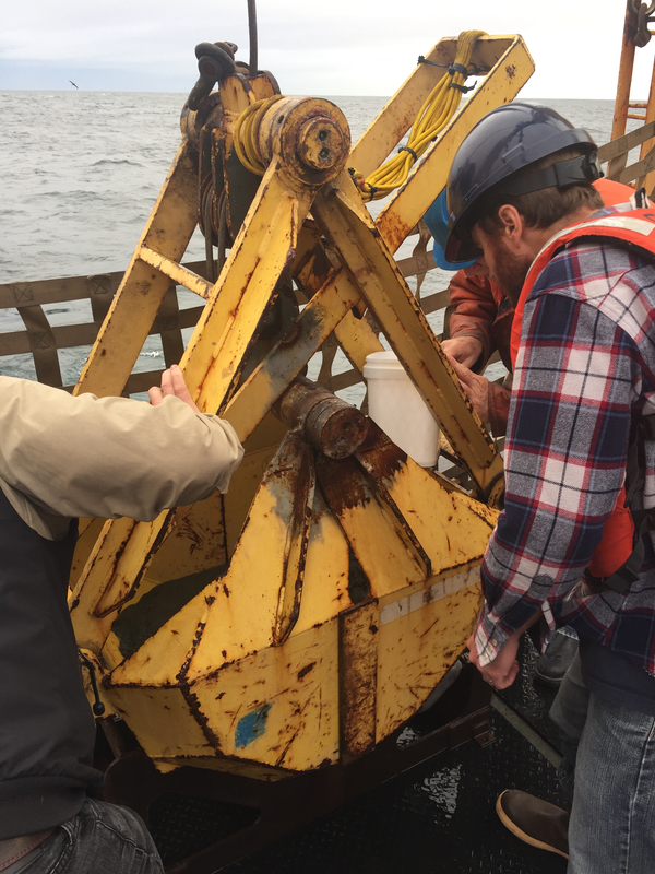
USGS science crew from Pacific Coastal and Marine Science Center work together to get the vibracorer coring device in position to collect sediment core samples off San Francisco, California.
James Conrad
I study seafloor geology along the West Coast of the U.S. using various types of geophysical surveys to map the seafloor and image sub-seafloor strata. The purpose of this work is to help understand the hazards posed to coastal communities and infrastructure by offshore active faults and submarine landslides.
I received a Bachelors Degree in Earth Science from U.C. Berkeley in 1981, and a Masters Degree in Geology from San Jose State University in 1993. I have worked at the USGS since 1981, first in the Minerals Program, where I worked to assess the potential for undiscovered mineral deposits in the western U.S., and used Argon geochronology to date mineral deposits and related igneous rocks. In 1995, I joined the Pacific Coastal and Marine Science Center, where I study marine geologic hazards such as earthquakes on offshore faults and tsunamis generated by submarine landslides.
Science and Products
Coastal and Marine Geohazards of the U.S. West Coast and Alaska
Coastal and marine geohazards are sudden and extreme events beneath the ocean that threaten coastal populations. Such underwater hazards include earthquakes, volcanic eruptions, landslides, and tsunamis.
By
Natural Hazards Mission Area, Coastal and Marine Hazards and Resources Program, Pacific Coastal and Marine Science Center, 3-D CT Core Imaging Laboratory, Core Preparation and Analysis Laboratory and Sample Repositories, Big Sur Landslides, Deep Sea Exploration, Mapping and Characterization, Subduction Zone Science

Rossfelder P-5 Vibracorer
USGS science crew from Pacific Coastal and Marine Science Center work together to get the vibracorer coring device in position to collect sediment core samples off San Francisco, California.

Vibracorer on deck
The Rossfelder P-5 vibracorer, with its polybuterate liner visible, is secured on the deck of the research vessel Bold Horizon, awaiting deployment off the coast of California just north of San Francisco. More liners are stored in a cage off to the side.
The Rossfelder P-5 vibracorer, with its polybuterate liner visible, is secured on the deck of the research vessel Bold Horizon, awaiting deployment off the coast of California just north of San Francisco. More liners are stored in a cage off to the side.
Examining bucket of seafloor sediment collected off southeast Alaska
USGS research geophysicist Danny Brothers (right) and colleagues examine the surface of a sediment grab sample just pulled onto the deck of the Canadian Coast Guard Ship John P. Tully. The sample was collected from the top of a mud volcano north of the border between southeast Alaska and British Columbia.
USGS research geophysicist Danny Brothers (right) and colleagues examine the surface of a sediment grab sample just pulled onto the deck of the Canadian Coast Guard Ship John P. Tully. The sample was collected from the top of a mud volcano north of the border between southeast Alaska and British Columbia.

Collecting a piston core of seafloor sediment off British Columbia
Scientists prepare to lower a piston corer off Haida Gwaii, British Columbia, to sample seafloor sediment near the Queen Charlotte-Fairweather fault. Expedition scientists are studying layers of sediment in the cores they collected to identify and determine ages of past earthquakes along the fault.
Scientists prepare to lower a piston corer off Haida Gwaii, British Columbia, to sample seafloor sediment near the Queen Charlotte-Fairweather fault. Expedition scientists are studying layers of sediment in the cores they collected to identify and determine ages of past earthquakes along the fault.

Sampling core fluid from sediment cores collected off southeast Alaska
Mary McGann (left, USGS) and Rachel Lauer (University of Calgary) sample pore fluids from sediment cores collected aboard the Canadian Coast Guard Ship John P. Tully along the Queen Charlotte-Fairweather fault offshore of southeast Alaska.
Mary McGann (left, USGS) and Rachel Lauer (University of Calgary) sample pore fluids from sediment cores collected aboard the Canadian Coast Guard Ship John P. Tully along the Queen Charlotte-Fairweather fault offshore of southeast Alaska.
Science and Products
- Science
Coastal and Marine Geohazards of the U.S. West Coast and Alaska
Coastal and marine geohazards are sudden and extreme events beneath the ocean that threaten coastal populations. Such underwater hazards include earthquakes, volcanic eruptions, landslides, and tsunamis.ByNatural Hazards Mission Area, Coastal and Marine Hazards and Resources Program, Pacific Coastal and Marine Science Center, 3-D CT Core Imaging Laboratory, Core Preparation and Analysis Laboratory and Sample Repositories, Big Sur Landslides, Deep Sea Exploration, Mapping and Characterization, Subduction Zone Science - Data
- Maps
- Multimedia
Rossfelder P-5 Vibracorer
USGS science crew from Pacific Coastal and Marine Science Center work together to get the vibracorer coring device in position to collect sediment core samples off San Francisco, California.
USGS science crew from Pacific Coastal and Marine Science Center work together to get the vibracorer coring device in position to collect sediment core samples off San Francisco, California.
Vibracorer on deckThe Rossfelder P-5 vibracorer, with its polybuterate liner visible, is secured on the deck of the research vessel Bold Horizon, awaiting deployment off the coast of California just north of San Francisco. More liners are stored in a cage off to the side.
The Rossfelder P-5 vibracorer, with its polybuterate liner visible, is secured on the deck of the research vessel Bold Horizon, awaiting deployment off the coast of California just north of San Francisco. More liners are stored in a cage off to the side.
Examining bucket of seafloor sediment collected off southeast AlaskaUSGS research geophysicist Danny Brothers (right) and colleagues examine the surface of a sediment grab sample just pulled onto the deck of the Canadian Coast Guard Ship John P. Tully. The sample was collected from the top of a mud volcano north of the border between southeast Alaska and British Columbia.
USGS research geophysicist Danny Brothers (right) and colleagues examine the surface of a sediment grab sample just pulled onto the deck of the Canadian Coast Guard Ship John P. Tully. The sample was collected from the top of a mud volcano north of the border between southeast Alaska and British Columbia.
Collecting a piston core of seafloor sediment off British ColumbiaScientists prepare to lower a piston corer off Haida Gwaii, British Columbia, to sample seafloor sediment near the Queen Charlotte-Fairweather fault. Expedition scientists are studying layers of sediment in the cores they collected to identify and determine ages of past earthquakes along the fault.
Scientists prepare to lower a piston corer off Haida Gwaii, British Columbia, to sample seafloor sediment near the Queen Charlotte-Fairweather fault. Expedition scientists are studying layers of sediment in the cores they collected to identify and determine ages of past earthquakes along the fault.
Sampling core fluid from sediment cores collected off southeast AlaskaMary McGann (left, USGS) and Rachel Lauer (University of Calgary) sample pore fluids from sediment cores collected aboard the Canadian Coast Guard Ship John P. Tully along the Queen Charlotte-Fairweather fault offshore of southeast Alaska.
Mary McGann (left, USGS) and Rachel Lauer (University of Calgary) sample pore fluids from sediment cores collected aboard the Canadian Coast Guard Ship John P. Tully along the Queen Charlotte-Fairweather fault offshore of southeast Alaska.
- Publications
- News