
Mike Duniway, Ph.D.
Dr. Michael (Mike) Duniway is a soil scientist focused on soils and soil processes in dryland ecosystems and the interactions between environmental and land-use drivers, vegetation, soils, and geomorphology. His areas of focus include restoration, ecohydrology, effects of land-use (grazing, energy, and recreation), dust production, plant-soil feedbacks, and soil mapping and interpretations.
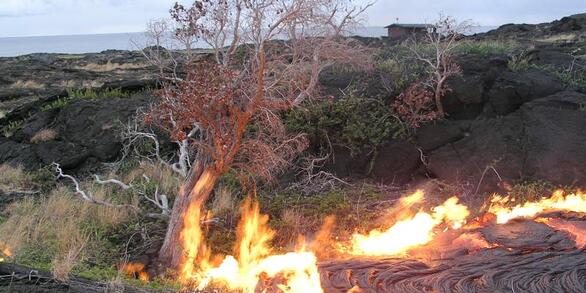
Drylands are highly vulnerable to climate and land use changes: what ecosystem changes are in store?

Learning From the Past and Planning for the Future: Experience-Driven Insight Into Managing for Ecosystem Transformations Induced by Drought and Wildfire
In his research and outreach activities, Dr. Duniway seeks to provide information for land managers and owners to facilitate sustainable land-use activities. He works closely with federal agency partners (Bureau of Land Management, National Park Service, National Resource Conservation Service, US Fish and Wildlife Service, and others such as The Nature Conservancy's Canyonlands Research Center) in designing research studies, conducting technology transfer, and outreach activities. Some primary current research focuses include understanding the impacts of drought on Colorado Plateau landscapes, evaluating the recovery of oil and gas pads on the Colorado Plateau and opportunities for improved restoration practices, developing novel restoration techniques for highly disturbed lands using biological soil crusts and physical barriers, and basic research into the importance of soils for dryland ecosystem processes.
Professional Experience
2011-Present: Research Ecologist, USGS Southwest Biological Science Center, Moab, UT
2010-2011: Research Soil Scientist, US Department of Agriculture Agricultural Research Service, Jornada, Las Cruces, NM
2006-2010: Research Soil Scientist (post doc), US Department of Agriculture Agricultural Research Service, Jornada, Las Cruces, NM
2012-Present: Adjunct Faculty, Utah State University, Logan, UT
2007-Present: Adjunct Faculty, NM State University, Las Cruces, NM
Education and Certifications
Ph.D., 2006 — Agronomy (Soil Science), New Mexico State University, Las Cruces, NM
B.S., 1994 — Environmental Resource Science, University of California, Davis, CA
Science and Products
Climate change reduces extent of temperate drylands and intensifies drought in deep soils
Human land-use and soil change
Generalizing ecological site concepts of the Colorado Plateau for landscape-level applications
Improving the effectiveness of ecological site descriptions: General state-and-transition models and the Ecosystem Dynamics Interpretive Tool (EDIT)
The automated reference toolset: A soil-geomorphic ecological potential matching algorithm
Testing the apparent resistance of three dominant plants to chronic drought on the Colorado Plateau
Small-scale barriers mitigate desertification processes and enhance plant recruitment in a degraded semiarid grassland
The National Wind Erosion Research Network: Building a standardized long-term data resource for aeolian research, modeling and land management
Spatially explicit rangeland erosion monitoring using high-resolution digital aerial imagery
Rangeland monitoring reveals long-term plant responses to precipitation and grazing at the landscape scale
Desert grassland responses to climate and soil moisture suggest divergent vulnerabilities across the southwestern United States
Pulse-drought atop press-drought: unexpected plant responses and implications for dryland ecosystems
Non-USGS Publications**
**Disclaimer: The views expressed in Non-USGS publications are those of the author and do not represent the views of the USGS, Department of the Interior, or the U.S. Government.
Science and Products
- Science
Filter Total Items: 21
- Data
Filter Total Items: 31No Result Found
- Multimedia
No results found.
- Publications
Filter Total Items: 101
Climate change reduces extent of temperate drylands and intensifies drought in deep soils
Drylands cover 40% of the global terrestrial surface and provide important ecosystem services. While drylands as a whole are expected to increase in extent and aridity in coming decades, temperature and precipitation forecasts vary by latitude and geographic region suggesting different trajectories for tropical, subtropical, and temperate drylands. Uncertainty in the future of tropical and subtropAuthorsDaniel R. Schlaepfer, John B. Bradford, William K. Lauenroth, Seth M. Munson, Britta Tietjen, Sonia A. Hall, Scott D. Wilson, Michael C. Duniway, Gensuo Jia, David A. Pyke, Ariuntsetseg Lkhagva, Khishigbayar JamiyansharavHuman land-use and soil change
Soil change refers to the alteration of soil and soil properties over time in one location, as opposed to soil variability across space. Although soils change with pedogensis, this chapter focuses on human caused soil change. Soil change can occur with human use and management over long or short time periods and small or large scales. While change can be negative or positive; often soil change iAuthorsSkye A. Wills, Candiss O. Williams, Michael C. Duniway, Jessica Veenstra, Cathy Seybold, DeAnn PressleyGeneralizing ecological site concepts of the Colorado Plateau for landscape-level applications
Numerous ecological site descriptions in the southern Utah portion of the Colorado Plateau can be difficult to navigate, so we held a workshop aimed at adding value and functionality to the current ecological site system.We created new groups of ecological sites and drafted state-and-transition models for these new groups.We were able to distill the current large number of ecological sites in theAuthorsMichael C. Duniway, Travis W. Nauman, Jamin K. Johanson, Shane Green, Mark E. Miller, Brandon T. BestelmeyerImproving the effectiveness of ecological site descriptions: General state-and-transition models and the Ecosystem Dynamics Interpretive Tool (EDIT)
State-and-transition models (STMs) are useful tools for management, but they can be difficult to use and have limited content.STMs created for groups of related ecological sites could simplify and improve their utility. The amount of information linked to models can be increased using tables that communicate management interpretations and important within-group variability.We created a new web-basAuthorsBrandon T. Bestelmeyer, Jeb C. Williamson, Curtis J. Talbot, Greg W. Cates, Michael C. Duniway, Joel R. BrownThe automated reference toolset: A soil-geomorphic ecological potential matching algorithm
Ecological inventory and monitoring data need referential context for interpretation. Identification of appropriate reference areas of similar ecological potential for site comparison is demonstrated using a newly developed automated reference toolset (ART). Foundational to identification of reference areas was a soil map of particle size in the control section (PSCS), a theme in US Soil Taxonomy.AuthorsTravis W. Nauman, Michael C. DuniwayTesting the apparent resistance of three dominant plants to chronic drought on the Colorado Plateau
Many drylands, including the south-western United States, are projected to become more water-limited as these regions become warmer and drier with climate change. Such chronic drought may push individual species or plant functional types beyond key thresholds leading to reduced growth or even mortality. Indeed, recent observational and experimental evidence from the Colorado Plateau suggests thatAuthorsDavid L. Hoover, Michael C. Duniway, Jayne BelnapSmall-scale barriers mitigate desertification processes and enhance plant recruitment in a degraded semiarid grassland
Anthropogenic desertification is a problem that plagues drylands globally; however, the factors which maintain degraded states are often unclear. In Canyonlands National Park on the Colorado Plateau of southeastern Utah, many degraded grasslands have not recovered structure and function >40 yr after release from livestock grazing pressure, necessitating active restoration. We hypothesized that mulAuthorsStephen E. Fick, Cheryl E. Decker, Michael C. Duniway, Mark E. MillerThe National Wind Erosion Research Network: Building a standardized long-term data resource for aeolian research, modeling and land management
The National Wind Erosion Research Network was established in 2014 as a collaborative effort led by the United States Department of Agriculture’s Agricultural Research Service and Natural Resources Conservation Service, and the United States Department of the Interior’s Bureau of Land Management, to address the need for a long-term research program to meet critical challenges in wind erosion reseaAuthorsNicholas P. Webb, Jeffrey E. Herrick, Justin W. Van Zee, Ericha M. Courtright, Ted M Hugenholtz, Ted M Zobeck, Gregory S. Okin, Thomas E Barchyn, Benjamin J Billings, Robert A. Boyd, Scott D Clingan, Brad F Cooper, Michael C. Duniway, Justin D. Derner, Fred A Fox, Kris M. Havstad, Philip Heilman, Valerie LaPlante, Noel A Ludwig, Loretta J Metz, Mark A Nearing, M Lee Norfleet, Frederick B Pierson, Matt A Sanderson, Brenton S Sharrat, Jean L Steiner, John Tatarko, Negussie H Tedela, David Todelo, Robert S Unnasch, R Scott Van Pelt, Larry WagnerSpatially explicit rangeland erosion monitoring using high-resolution digital aerial imagery
Nearly all of the ecosystem services supported by rangelands, including production of livestock forage, carbon sequestration, and provisioning of clean water, are negatively impacted by soil erosion. Accordingly, monitoring the severity, spatial extent, and rate of soil erosion is essential for long-term sustainable management. Traditional field-based methods of monitoring erosion (sediment traps,AuthorsJeffrey K. Gillan, Jason W. Karl, Nichole N. Barger, Ahmed Elaksher, Michael C. DuniwayRangeland monitoring reveals long-term plant responses to precipitation and grazing at the landscape scale
Managers of rangeland ecosystems require methods to track the condition of natural resources over large areas and long periods of time as they confront climate change and land use intensification. We demonstrate how rangeland monitoring results can be synthesized using ecological site concepts to understand how climate, site factors, and management actions affect long-term vegetation dynamics at tAuthorsSeth M. Munson, Michael C. Duniway, Jamin K. JohansonDesert grassland responses to climate and soil moisture suggest divergent vulnerabilities across the southwestern United States
Climate change predictions include warming and drying trends, which are expected to be particularly pronounced in the southwestern United States. In this region, grassland dynamics are tightly linked to available moisture, yet it has proven difficult to resolve what aspects of climate drive vegetation change. In part, this is because it is unclear how heterogeneity in soils affects plant responsesAuthorsJennifer Gremer, John B. Bradford, Seth M. Munson, Michael C. DuniwayPulse-drought atop press-drought: unexpected plant responses and implications for dryland ecosystems
In drylands, climate change is predicted to cause chronic reductions in water availability (press-droughts) through reduced precipitation and increased temperatures as well as increase the frequency and intensity of short-term extreme droughts (pulse-droughts). These changes in precipitation patterns may have profound ecosystem effects, depending on the sensitivities of the dominant plant functionAuthorsDavid L. Hoover, Michael C. Duniway, Jayne BelnapNon-USGS Publications**
Browning, D.M., Duniway, M.C., Laliberte, A., and Rango, A., 2012, Hierarchical analysis of vegetation dynamics over 71 years: Soil-rainfall interactions in a Chihuahuan desert ecosystem: Ecological Applications, v. 22, p.909-926.Duniway, M., Karl, J., Schrader, S., Baquera, N., and Herrick, J., 2012, Rangeland and pasture monitoring: an approach to interpretation of high-resolution imagery focused on observer calibration for repeatability: Environmental Monitoring and Assessment, v. 184, p. 3789-3804.Karl, J., Duniway, M.C., Nusser, S.M., Opsomer, J.D., and Unnasch, R.S., 2012, Using Very-Large-Scale Aerial Imagery for Rangeland Monitoring and Assessment: Some Statistical Considerations: Rangeland Ecology & Management, v. 65, p. 330-339.Karl, J.W., Duniway, M.C., and Schrader, T.S., 2012, A Technique for Estimating Rangeland Canopy-Gap Size Distributions From High-Resolution Digital Imagery: Rangeland Ecology & Management, v. 65, p. 196-207.Browning, D.M., and Duniway, M.C., 2011, Digital soil mapping in the absence of field training data: a case study using terrain attributes and semiautomated soil signature derivation to distinguish ecological potential: Applied and Environmental Soil Science.Duniway, M.C., and Herrick, J.E., 2011, Disentangling road network impacts: the need for a holistic approach: Journal of Soil and Water Conservation, v. 66, p. 31A-36A.Peters, D.P.C., Lugo, A.E., Chapin, F.S., Pickett, S.T.A., Duniway, M.C., Rocha, A.V., Swanson, F.J., Laney, C., and Jones, J., 2011, Cross-system comparisons elucidate disturbance complexities and generalities: Ecosphere, v. 2, art. 81.Schrader, T.S., and Duniway, M.C., 2011, Image Interpreter Tool: An ArcGIS tool for estimating vegetation cover from high-resolution imagery: Rangelands, v. 33, p. 35-40.Duniway, M., Herrick, J., and Monger, H., 2010, Spatial and temporal variability of plant-available water in calcium carbonate-cemented soils and consequences for arid ecosystem resilience: Oecologia, v. 163, p. 215-226.Duniway, M.C., Bestelmeyer, B.T., and Tugel, A., 2010, Soil processes and properties that distinguish ecological sites and states: Rangelands, v. 32, p. 9-15.Duniway, M.C., Snyder, K.A., and Herrick, J.E., 2010, Spatial and temporal patterns of water availability in a grass–shrub ecotone and implications for grassland recovery in arid environments: Ecohydrology, v. 3, p. 55-67.Duniway, M.C., Herrick, J.E., and Monger, H.C., 2007, The high water-holding capacity of petrocalcic horizons: Soil Science Society of America Journal, v. 71, p. 812-819.Duniway, M.C., 2006, The functional role of petrocalcic horizons in desert ecosystems: spatial and temporal dynamics of plant water availability [Ph.D. Dissertation]: New Mexico State Univeristy, Las Cruces, New Mexico, USA.**Disclaimer: The views expressed in Non-USGS publications are those of the author and do not represent the views of the USGS, Department of the Interior, or the U.S. Government.
- Web Tools
- News