
Lidar for Typhoon Merbok
In FY 2023, USGS received disaster supplement funds (Public Law 117-328) to obtain high-resolution lidar data to aid in risk assessment of rural coastal villages.
Typhoon Merbok lidar: tasks and benefits 2023
-
 Sources/Usage: Public Domain. View Media Details
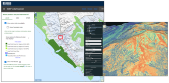
A demonstration of the function of the 3DEP LidarExplorer shows a screenshot on the left with basic choices for a selected area. On the right, additional options allow the viewer to make more detailed selections. Current, high-resolution elevation data are essential for rural coastal villages in western Alaska impacted by Typhoon Merbok to protect natural resources, infrastructure, and—most importantly—human life.
- Funding will be used by the USGS 3D Elevation Program to obtain about 6,000 square miles of light detection and ranging (lidar) data for 36 rural villages. Several of the affected coastal communities are at sea level and under direct threat of flooding and erosion worsened by climate change. Loss of permafrost, more frequent freeze-thaw cycles, and intense storms are causing land subsidence and bank erosion along rivers and coastlines, further threatening structures and communities.
- Lidar data will be used in assessments of coastal and riverbank erosion, mapping flood risk, predicting sea-level rise impacts, and other recovery efforts. The lidar data will be used by Federal programs to aid in managed retreat, village relocation planning for homes and infrastructure in flood hazard zones that are expanding due to severe erosion and permafrost thaw, or both.