
Natural Hazards
How do volcanoes erupt?
Can you predict earthquakes?
Does the USGS conduct studies on wildfire?
What is a landslide and what causes one?
The USGS monitors and conducts research on a wide range of natural hazards to help decision-makers prepare for and respond to hazard events that threaten life and property.

Why do earthquakes occur in the middle of the continent far from plate boundaries? Why do earthquakes occur in the middle of the continent far from plate boundaries?
Most earthquakes occur near tectonic plate boundaries, where the Earth's crust is composed of large fragments that interact with one another. These interactions can involve plates sliding past each other, colliding, or moving apart. However, a map of the U.S. shows that earthquakes also take place in the interior regions of the continent, though less frequently than those along the edges. This...

Does the USGS conduct studies on wildfire? Does the USGS conduct studies on wildfire?
Yes. The USGS Wildland Fire Science Program produces information to identify the causes of wildfires, understand the impacts and benefits of both wildfires and prescribed fires, and help prevent and manage larger, catastrophic events. Our fire scientists provide data, tools and information that are used by fire and land managers to make decisions before, during, and after wildfires in ecosystems...
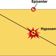
What reference datum is used for earthquake depths? What reference datum is used for earthquake depths?
The USGS currently uses the WGS84 Geoid as the reference datum for earthquake depths. Other seismic networks might or might not use different methods. The choice of reference datum depends on the method used to locate the earthquake, which varies by seismic network. The Advanced National Seismic System Comprehensive Earthquake Catalog (ComCat) includes data from many different seismic networks, so...

Can large amounts of rain in California cause an increase in earthquakes? Can large amounts of rain in California cause an increase in earthquakes?
There is no pattern in California of large, damaging earthquakes occurring more frequently during periods of heavy precipitation or periods of drought. Therefore, it’s unlikely that seismic hazard is affected by precipitation. This makes sense as rainwater cannot easily percolate several kilometers below the earth's surface to the depths where most earthquakes occur. However, periods of heavy...

What is a debris flow? What is a debris flow?
Debris flows are fast-moving landslides that are particularly dangerous to life and property because they move quickly, destroy objects in their paths, and often strike without warning. They occur in a wide variety of environments throughout the world, including all 50 states and U.S. Territories. Debris flows generally occur during periods of intense rainfall or rapid snowmelt and usually start...

How do I sign up for the ShakeAlert® Earthquake Early Warning System? How do I sign up for the ShakeAlert® Earthquake Early Warning System?
How do I sign up to receive ShakeAlert®-powered Alerts on my phone? Provider Type Apple Store Google Play Link States USGS/FEMA Wireless Emergency Alerts N/A FEMA | WEA CA/OR/WA MyShake TM Mobile App Y/Y MyShake CA/OR/WA Google Android Operating System N/A Google CA/OR/WA Alert San Diego with ShakeReadySD Mobile App Y/Y Alert San Diego CA The USGS issues ShakeAlert ® Messages but alert delivery...

Does the Latest Earthquakes map show non-earthquake seismic events? Does the Latest Earthquakes map show non-earthquake seismic events?
In addition to naturally occurring earthquakes, human activities such as mining and construction blasts can sometimes produce seismic waves large enough to be detected on the USGS national seismic network. These artificially-generated events have a different seismic ‘fingerprint’ from tectonic earthquakes, so they can be discerned by a seismologist when reviewed. Specifically, small quarry blasts...

Where can I find wildfire perimeter data? Where can I find wildfire perimeter data?
The USGS operated the Geospatial Multi-Agency Coordination (GeoMAC) website from 2000-2020. GeoMAC was the public face of all wildland fire perimeters. That site was shut down on April 30, 2020 and responsibility for wildfire information was transferred to the National Interagency Fire Center (NIFC). Data previously at "rmgsc.cr.usgs.gov/outgoing/GeoMAC/" is now at National Interagency Fire Center...

Where are the faults in the Central and Eastern U.S.? Where are the faults in the Central and Eastern U.S.?
Faults vs. Fault Lines on a Map In order to answer this question, we first need to explain some basics about faults. Faults are different from fault lines. A fault is a three-dimensional surface within the planet that might extend up to the surface or might be completely buried. In contrast, a fault line is where the fault cuts the Earth's surface… if indeed it does. The most prominent faults in...

Can a large earthquake trigger earthquakes in distant locations or on other faults? Can a large earthquake trigger earthquakes in distant locations or on other faults?
Sometimes. Earthquakes, particularly large ones, can trigger other earthquakes in more distant locations though a process known as dynamic stress transfer/triggering. This means that the energy from the seismic wave passing through can cause a new earthquake, usually in already vulnerable locations prone to frequent earthquakes (e.g., volcanic regions). Examples of large events that triggered...

What is a hotspot and how do you know it's there? What is a hotspot and how do you know it's there?
Most volcanic eruptions occur near the boundaries of tectonic plates, but there are some exceptions. In the interior of some tectonic plates, magma has been erupting from a relatively fixed spot below the plate for millions of years. As the plate continuously moves across that spot, a trail of progressively older volcanic deposits is left at the surface. The Hawaiian Islands are a good example of...

Does fracking cause earthquakes? Does fracking cause earthquakes?
Most induced earthquakes are not directly caused by hydraulic fracturing (fracking). The recent increase in earthquakes in the central United States is primarily caused by disposal of waste fluids that are a byproduct of oil production. Wastewater disposal wells typically operate for longer durations and inject much more fluid than is injected during the hydraulic fracturing process, making them...