
Landsat 1 views Alaska Fire

Detailed Description
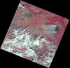
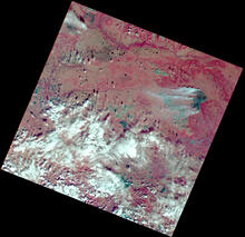
Within days of the launch, Landsat 1 acquired an image of an astounding 81,000-acre (327.8 square kilometers) fire burning in isolated, central Alaska. For the first time ever, scientists and resource management officials were able to see the full extent of damage from a fire in a single image while it was still burning.
This false color image was acquired on July 27, 1972 from Path 83 Row 13 and is shown using the near infrared, red, and green bands (Bands 7,5,4).
Learn more on the Landsat 1 mission web page
Sources/Usage
Public Domain.