
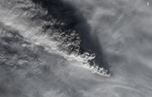
Satellite image of eruption cloud from Pavlof Volcano in November 2014

Detailed Description
Satellite image from the USGS/NASA Landsat-8 satellite showing the eruption cloud at Pavlof Volcano on November 15 at 12:46 pm AKST (21:46 UTC). This is just a portion of the eruption cloud, which extended for more than 250 miles to the northwest at the time this image was collected. In this image, the distance from the erupting vent to the upper left corner of the image is 45 miles (70 km). The shadow of the eruption cloud on the underlying meteorological clouds can be seen in this image. Pilots reported the height of the cloud at 35,000 ft (10.7 km) above sea level.
Sources/Usage
Public Domain.