U.S. flag

An official website of the United States government

Natural Hazards Mission Area

Every year in the United States, natural hazards threaten lives and livelihoods and result in billions of dollars in damage. We work with many partners to monitor, assess, and conduct targeted research on a wide range of natural hazards so that policymakers and the public have the understanding they need to enhance preparedness, response, and resilience.

News

Great Salt Lake sediments record thousands of years of earthquake history

Great Salt Lake sediments record thousands of years of earthquake history

New high-resolution geophysics in the Outer California Borderland

New high-resolution geophysics in the Outer California Borderland

USGS Remote Sensing Data Tracks Coastal Change from Hurricanes Helene and Milton

USGS Remote Sensing Data Tracks Coastal Change from Hurricanes Helene and Milton

Publications

2026–2031 U.S. Geological Survey strategy for a hazard ready Nation—Actionable science for risk reduction 2026–2031 U.S. Geological Survey strategy for a hazard ready Nation—Actionable science for risk reduction

Executive Summary The USGS Strategy for a Hazard Ready Nation provides an approach that U.S. Geological Survey (USGS) researchers and staff can use to deliver actionable, user-focused science that supports risk-informed decision making aimed at reducing risk and losses across the Nation. The Strategy builds upon successful efforts within the USGS and seeks to promote and prioritize...
Authors
Alice B. Pennaz, Jack R. Friedman, Nathan J. Wood, Jacqueline R. Meszaros

The digital archivist: Automating legacy macroseismic data processing using large language models The digital archivist: Automating legacy macroseismic data processing using large language models

Macroseismic data are a key resource to investigate shaking and damage from preinstrumental and early instrumental eras. However, data are often stored as inconsistently formatted reports describing observed shaking and damage, making manually parsing and interpreting accounts labor‐intensive. We introduce a novel workflow using Google’s Gemini 2.5 Pro large language model (LLM) to...
Authors
Aarnav Agrawal, Susan E. Hough, Mostafa Mousavi, Margaret Hellweg, William Ellsworth, Clara Yoon, Salvador Blanco

Mars as one system: Insights from the 8th international conference on Mars polar science and exploration Mars as one system: Insights from the 8th international conference on Mars polar science and exploration

The 8th International Conference on Mars Polar Science and Exploration (ICMPSE) provided new insights into the complex interplay between Martian ice, climate, and atmospheric dynamics. The conference emphasized a holistic view of Mars as a system, where surface processes, subsurface ice, atmospheric dynamics, and historical climate shifts are interconnected. Research updates spanned...
Authors
Isaac B. Smith, Chimira Andres, Shannon Hibbard, Stefano Nerozzi, Roberto Aguilar, Peter Buhler, Ben Cornford, Leslie Tamppari, Timothy N. Titus

Science

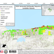
2026 Venezuela Sequence Earthquake-Triggered Landslide Hazards

On Wednesday, June 24th, 2026, a pair of earthquakes of Magnitude 7.2 and Magnitude 7.5 occurred in northern Venezuela, west of Caracas. The U.S. Geological Survey (USGS) Ground Failure product estimated that landslides triggered by this earthquake would likely be significant in number and/or spatial extent. This landslide event page serves to communicate timely science information to our partners...
2026 Venezuela Sequence Earthquake-Triggered Landslide Hazards

2026 Venezuela Sequence Earthquake-Triggered Landslide Hazards

On Wednesday, June 24th, 2026, a pair of earthquakes of Magnitude 7.2 and Magnitude 7.5 occurred in northern Venezuela, west of Caracas. The U.S. Geological Survey (USGS) Ground Failure product estimated that landslides triggered by this earthquake would likely be significant in number and/or spatial extent. This landslide event page serves to communicate timely science information to our partners...
Learn More

COAWST: A Coupled-Ocean-Atmosphere-Wave-Sediment Transport Modeling System

Understanding the processes responsible for coastal change is important for managing both our natural and economic coastal resources. Storms are one of the primary driving forces causing coastal change from a coupling of wave- and wind-driven flows. To better understand storm impacts and their effects on our coastlines, there is an international need to better predict storm paths and intensities...
COAWST: A Coupled-Ocean-Atmosphere-Wave-Sediment Transport Modeling System

COAWST: A Coupled-Ocean-Atmosphere-Wave-Sediment Transport Modeling System

Understanding the processes responsible for coastal change is important for managing both our natural and economic coastal resources. Storms are one of the primary driving forces causing coastal change from a coupling of wave- and wind-driven flows. To better understand storm impacts and their effects on our coastlines, there is an international need to better predict storm paths and intensities...
Learn More

Typhoon Merbok Disaster Recovery Project: Accomplishments

Supported by Title VII of Division N of the Consolidated Appropriations Act, 2023, the Typhoon Merbok Disaster Emergency Recovery Efforts project addresses critical data and capacity gaps in coastal Alaska by generating high resolution environmental datasets, hazard analyses, and monitoring tools needed to quantify erosion, flooding, and permafrost-related risks at the community scale.
Typhoon Merbok Disaster Recovery Project: Accomplishments

Typhoon Merbok Disaster Recovery Project: Accomplishments

Supported by Title VII of Division N of the Consolidated Appropriations Act, 2023, the Typhoon Merbok Disaster Emergency Recovery Efforts project addresses critical data and capacity gaps in coastal Alaska by generating high resolution environmental datasets, hazard analyses, and monitoring tools needed to quantify erosion, flooding, and permafrost-related risks at the community scale.
Learn More
Was this page helpful?