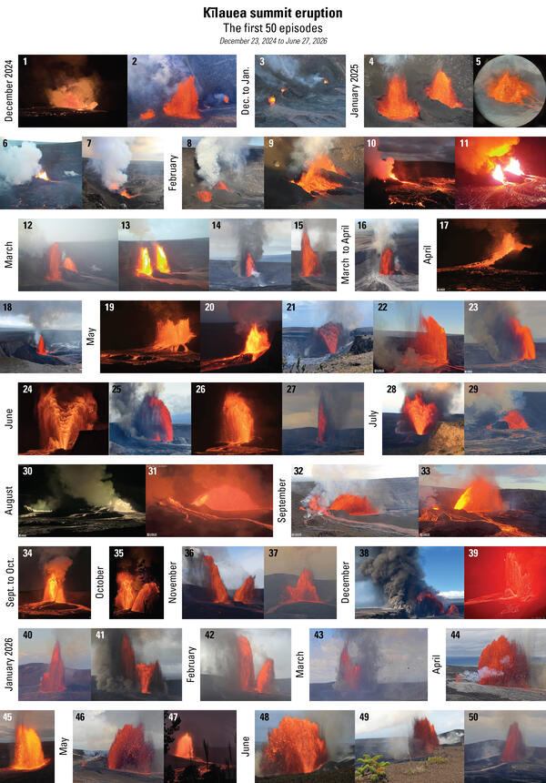
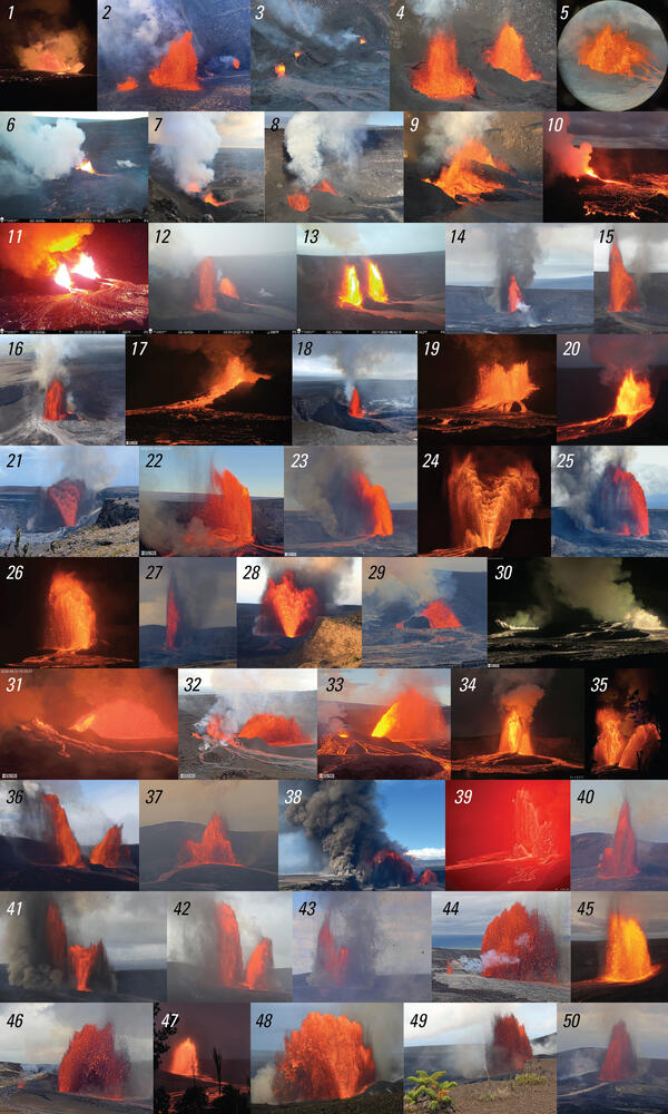
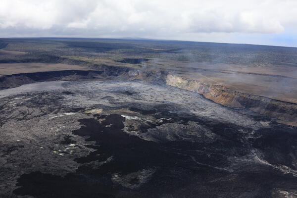
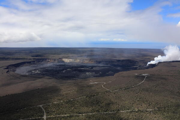
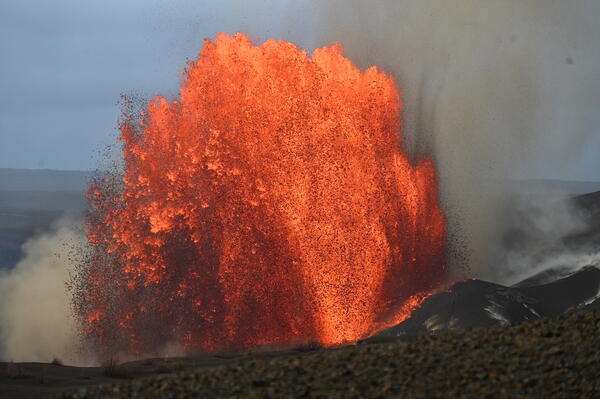
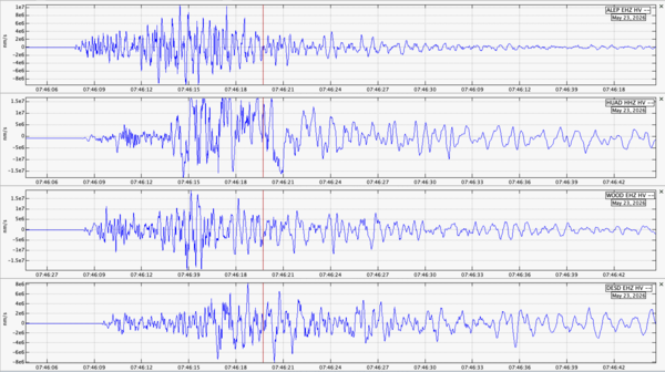
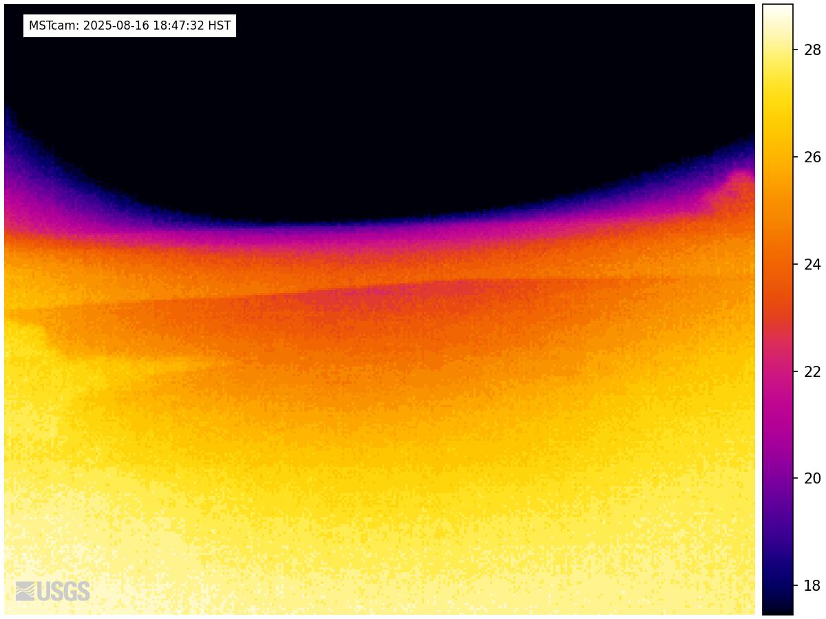
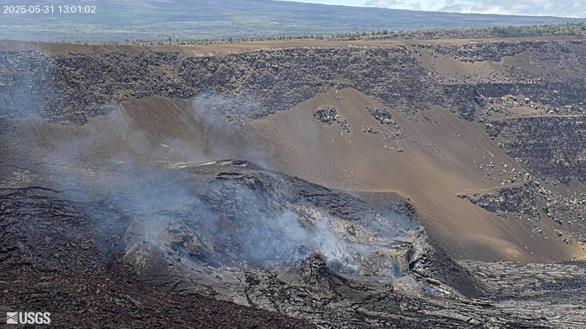
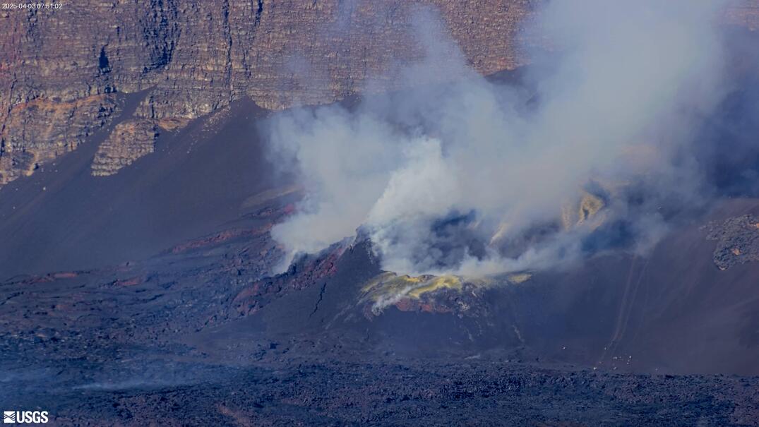
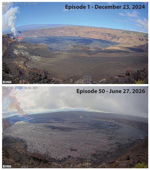
U.S. flag

An official website of the United States government

Multimedia

Webcams—Near-real-time images from webcams.

Videos—Collection of videos recorded during field excursions or caught on our webcams.

Image Galleries—Galleries of images and events with expanded descriptions.

The Kīlauea Photo and Video Chronology and Mauna Loa Photo and Video Chronology webpages also feature photos. 

Images

Color infographic showing lava fountain and information about eruption
A Fountain-Filled Year at Kīlauea - Infographic

It's been one year since a unique episodic lava fountaining eruption began at Kīlauea’s summit on December 23, 2024—a style of activity not seen in nearly 40 years! Over the past 12 months, Halemaʻumaʻu crater has hosted 38 eruptive episodes, each lasting from a few hours to more than a week, separated by quiet pauses.

It's been one year since a unique episodic lava fountaining eruption began at Kīlauea’s summit on December 23, 2024—a style of activity not seen in nearly 40 years! Over the past 12 months, Halemaʻumaʻu crater has hosted 38 eruptive episodes, each lasting from a few hours to more than a week, separated by quiet pauses.

Color map showing lava thickness in crater
December 22, 2025—Kīlauea summit eruption lava thickness through episode 38

This map shows thickness values for lava flows within Halema‘uma‘u crater from the Kīlauea summit eruption that began on December 23, 2024. These values were calculated by topographic differencing between a digital elevation model collected on December 9, 2025—after eruptive episode 38—and one from before the eruption began.

This map shows thickness values for lava flows within Halema‘uma‘u crater from the Kīlauea summit eruption that began on December 23, 2024. These values were calculated by topographic differencing between a digital elevation model collected on December 9, 2025—after eruptive episode 38—and one from before the eruption began.

Color graphic showing episodes of volcanic eruption over time
December 23, 2025 — Photo compilation for the 1-year anniversary of the ongoing eruption at the summit of Kīlauea

Photo compilation of the 38 lava fountaining episodes that occurred the first year of the ongoing eruption at the summit of Kīlauea. The eruption started on December 23, 2024, and the eruption continues: episode 39 is expected soon.

Color graphic showing labelled eruption photos over a year
December 23, 2025 — Photo calendar compilation for the 1-year anniversary of the ongoing eruption at the summit of Kīlauea

Photo calendar compilation of the 38 lava fountaining episodes that occurred the first year of the ongoing eruption at the summit of Kīlauea, with month time-stamps. The eruption started on December 23, 2024, and the eruption continues: episode 39 is expected soon.

Color photograph of volcanic deposits
December 19, 2025 — Episode 38 tephra deposits along Kīlauea caldera rim

During a monitoring helicopter overflight on December 19, 2025, USGS geologists captured this southwest looking photo of the tephra hill that has grown over the past year of episodic lava fountaining at the summit of Kīlauea.

During a monitoring helicopter overflight on December 19, 2025, USGS geologists captured this southwest looking photo of the tephra hill that has grown over the past year of episodic lava fountaining at the summit of Kīlauea.

Color photograph of cliff covered with slumping volcanic deposits
December 19, 2025 — Aerial view of Kīlauea tephra hill

Aerial photo showing the tephra hill on the western margin of Kaluapele (Kīlauea caldera), which has grown over the past year of 38 lava fountaining episodes within Halema‘uma‘u. The arcuate scarps are from landslides of tephra that have fallen back into the caldera near the north and south vents that have erupted all the material making up the tephra hill.

Aerial photo showing the tephra hill on the western margin of Kaluapele (Kīlauea caldera), which has grown over the past year of 38 lava fountaining episodes within Halema‘uma‘u. The arcuate scarps are from landslides of tephra that have fallen back into the caldera near the north and south vents that have erupted all the material making up the tephra hill.

Videos

Color photograph of volcanic landscape Color photograph of volcanic landscape
December 9, 2025—Aerial video of Halemaʻumaʻu crater after episode 38

On December 9, USGS-Hawaiian Volcano Observatory geologists conducted an aerial overflight of Kīlauea summit region, following lava fountaining episode 38 of the Halemaʻumaʻu eruption on December 6. In this video, the line on the ground in the lower left portion at the start of the video shows the extent of tephra deposits created during episode 38.

On December 9, USGS-Hawaiian Volcano Observatory geologists conducted an aerial overflight of Kīlauea summit region, following lava fountaining episode 38 of the Halemaʻumaʻu eruption on December 6. In this video, the line on the ground in the lower left portion at the start of the video shows the extent of tephra deposits created during episode 38.

Color photograph of incandescent lava particles falling to the ground Color photograph of incandescent lava particles falling to the ground
December 6, 2025—Video of V3cam being destroyed by lava fountain

The V3 camera was located on the south rim of Halema‘uma‘u crater at the summit of Kīlauea volcano on the Island of Hawai‘i. The camera, located in a hazardous closed area of Hawai‘i Volcanoes National Park, was buried by tephra from an inclined lava fountain between 9:55 and 9:57 am HST on December 6, during episode 38 that began this morning at 8:45 am.

The V3 camera was located on the south rim of Halema‘uma‘u crater at the summit of Kīlauea volcano on the Island of Hawai‘i. The camera, located in a hazardous closed area of Hawai‘i Volcanoes National Park, was buried by tephra from an inclined lava fountain between 9:55 and 9:57 am HST on December 6, during episode 38 that began this morning at 8:45 am.

Color photograph of lava fountain with tree in foreground Color photograph of lava fountain with tree in foreground
December 6, 2025—Video views of episode 38 in Halemaʻumaʻu crater, Kīlauea summit

Views of Kīlauea summit eruption lava fountaining episode 38 in Halema‘uma‘u crater on the Island of Hawai‘i. This eruptive episode began from the north vent at about 8:45 am HST this morning, December 6.

Color photograph of volcanic crater with vents and lava flows Color photograph of volcanic crater with vents and lava flows
December 2, 2025—Halemaʻumaʻu crater overflight video

The USGS Hawaiian Volcano Observatory conducted the monitoring overflight of Halema‘uma‘u crater the morning of December 2, 2025.

View of volcanic vent that is degassing View of volcanic vent that is degassing
December 2, 2025—Halemaʻumaʻu north vent video

During a USGS Hawaiian Volcano Observatory monitoring overflight the morning of December 2, 2025, geologists were able to see a spattering lava surface deep within the north vent. The yellow material around the vents is native sulfur.

During a USGS Hawaiian Volcano Observatory monitoring overflight the morning of December 2, 2025, geologists were able to see a spattering lava surface deep within the north vent. The yellow material around the vents is native sulfur.

Color photograph of lava fountains Color photograph of lava fountains
November 25, 2025—Video of Kīlauea summit eruption episode 37

Episode 37 of the Kīlauea summit eruption in Halemaʻumaʻu began November 25 at 2:30 p.m. with lava fountaining from the north vent.  A wide fountain developed, eventually reaching heights of 500-600 ft (150-180 meters), sending flows across a broad portion of the crater floor.

Episode 37 of the Kīlauea summit eruption in Halemaʻumaʻu began November 25 at 2:30 p.m. with lava fountaining from the north vent.  A wide fountain developed, eventually reaching heights of 500-600 ft (150-180 meters), sending flows across a broad portion of the crater floor.

Audio

Kīlauea's Summit Vent Churns and Pops as Rocks Fall Into the Lava L...
Kīlauea's Summit Vent Churns and Pops as Rocks Fall Into Lava Lake
Lava lake activity from inside Halema`uma`u Crater
Kīlauea's Summit Vent Churns and Pops as Rocks Fall Into the Lava L...
Kīlauea's Summit Vent Churns and Pops as Rocks Fall Into Lava Lake
Lava lake activity from inside Halema`uma`u Crater

Sounds of lava lake activity within Kilauea Volcano's summit vent inside Halema`uma`u Crater on the afternoon of February 14, 2011. The continuous "crashing wave" noise is the sound of churning lava as gases are released from the lake surface, which is in nearly constant motion.

Sounds of lava lake activity within Kilauea Volcano's summit vent inside Halema`uma`u Crater on the afternoon of February 14, 2011. The continuous "crashing wave" noise is the sound of churning lava as gases are released from the lake surface, which is in nearly constant motion.

USGS CoreCast
USGS CoreCast Series
Dramatic Developments at Kilauea Volcano
USGS CoreCast
USGS CoreCast Series
Dramatic Developments at Kilauea Volcano

Kilauea Volcano in Hawaii has experienced its first explosive eruption in more than 80 years and is now spewing noxious gas at 10 times the normal rate. John Eichelberger, head of the USGS Volcano Hazards Program, fills us in on the situation.

Kilauea Volcano in Hawaii has experienced its first explosive eruption in more than 80 years and is now spewing noxious gas at 10 times the normal rate. John Eichelberger, head of the USGS Volcano Hazards Program, fills us in on the situation.

Webcams

webcam image of flank of volcano
[MSTcam] South Pit and Upper Southwest Rift Zone - thermal image from Moku‘āweoweo south rim
[MSTcam] South Pit and Upper Southwest Rift Zone - thermal image from Moku‘āweoweo south rim
[MSTcam] South Pit and Upper Southwest Rift Zone - thermal image from Moku‘āweoweo south rim

This image is from a research camera positioned on the south rim of Mokuʻāweoweo, Mauna Loa's summit caldera, in Hawaiʻi Volcanoes National Park. The camera looks west-southwest, across South Pit, focusing on the south part of Mauna Loa's summit region and upper Southwest Rift Zone.

This image is from a research camera positioned on the south rim of Mokuʻāweoweo, Mauna Loa's summit caldera, in Hawaiʻi Volcanoes National Park. The camera looks west-southwest, across South Pit, focusing on the south part of Mauna Loa's summit region and upper Southwest Rift Zone.

Color webcam image
[V3cam] Kīlauea volcano, Hawaii (south Halemaʻumaʻu crater)
[V3cam] Kīlauea volcano, Hawaii (south Halemaʻumaʻu crater)
[V3cam] Kīlauea volcano, Hawaii (south Halemaʻumaʻu crater)

Last 24 Hours - Live view of Halemaʻumaʻu crater within Kaluapele (Kīlauea caldera), from the south rim of the crater [V3cam]. This camera is a pan-tilt-zoom model and the view may change depending on activity.

Disclaimer

Last 24 Hours - Live view of Halemaʻumaʻu crater within Kaluapele (Kīlauea caldera), from the south rim of the crater [V3cam]. This camera is a pan-tilt-zoom model and the view may change depending on activity.

Disclaimer

Color image of caldera
[V2cam] Kīlauea volcano, Hawaii (east Halemaʻumaʻu crater)
[V2cam] Kīlauea volcano, Hawaii (east Halemaʻumaʻu crater)
[V2cam] Kīlauea volcano, Hawaii (east Halemaʻumaʻu crater)

Live view of Kaluapele (Kīlauea caldera) and Halemaʻumaʻu crater, from the northeast rim of the caldera [V2cam]. This camera is a pan-tilt-zoom model and the view may change depending on activity.

Disclaimer

Live view of Kaluapele (Kīlauea caldera) and Halemaʻumaʻu crater, from the northeast rim of the caldera [V2cam]. This camera is a pan-tilt-zoom model and the view may change depending on activity.

Disclaimer

Color image of volcano
[KOcam] Live Image of upper East Rift Zone from Maunaulu
[KOcam] Live Image of upper East Rift Zone from Maunaulu
[KOcam] Live Image of upper East Rift Zone from Maunaulu

This image is from a temporary research camera positioned near Maunaulu, looking northwest toward the upper East Rift Zone of Kīlauea.

Disclaimer

Color webcam image showing rift zone of volcano
[MDLcam] The Upper and Middle Parts of Mauna Loa's Southwest Rift Zone
[MDLcam] The Upper and Middle Parts of Mauna Loa's Southwest Rift Zone
[MDLcam] The Upper and Middle Parts of Mauna Loa's Southwest Rift Zone

Live image of Mauna Loa's upper and middle Southwest Rift Zone from Dandelion Cone along the middle part of the rift zone [MDLcam]. This camera is a pan-tilt-zoom model and the view may change depending on activity.


Disclaimer

Live image of Mauna Loa's upper and middle Southwest Rift Zone from Dandelion Cone along the middle part of the rift zone [MDLcam]. This camera is a pan-tilt-zoom model and the view may change depending on activity.


Disclaimer

Color webcam image showing flank of volcano
[MSPcam] Mauna Loa's Southwest Rift Zone from the South Point area
[MSPcam] Mauna Loa's Southwest Rift Zone from the South Point area
[MSPcam] Mauna Loa's Southwest Rift Zone from the South Point area

Live image of Mauna Loa's Southwest Rift Zone from the South Point area [MSPcam]. This camera is a pan-tilt-zoom model and the view may change depending on activity.


Disclaimer

Live image of Mauna Loa's Southwest Rift Zone from the South Point area [MSPcam]. This camera is a pan-tilt-zoom model and the view may change depending on activity.


Disclaimer

Was this page helpful?