
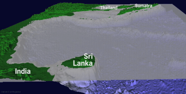
Tsunami wavefield for the 2004 Sumatra earthquake
Detailed Description
Tsunami wavefield for the 2004 Sumatra-Andaman earthquake 1 hour after generation, view to the east
This animation shows a model of the tsunami generated by the December 26, 2004 earthquake. The first 3 hours of tsunami propagation are shown. The tsunami is generated between the island of Sumatra and the Sunda Trench. It then propagates outward into the Bay of Bengal toward Sri Lanka and India and to the east toward Sumatra and Thailand. Largest offshore tsunami amplitudes are in the Banda Aceh region of northern Sumatra.
Sources/Usage
Public Domain.