
Evaluating potential vectors of annual grass invasion
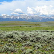
Invasive annual grasses, facilitated by a range of disturbances, are invading many areas within the sagebrush biome. Researchers from the U.S. Geological Survey, Colorado State University, U.S. Fish and Wildlife Service and the Bureau of Land Management are investigating which non-fire disturbances are most associated with the spread of invasive grasses. The findings from this study could guide decisions regarding the management of disturbances and activities that serve as vectors of invasion.
Background
In sagebrush ecosystems, wildfires have helped invasive annual grasses spread, creating significant challenges for resource managers. Although we understand how wildfire and cheatgrass interact, we do not fully know which non-fire disturbances (such as, infrastructure development or use) most consistently help these grasses spread. The impact of each disturbance can vary depending on factors like the type of disturbance, the area it affects, the intensity of the existing invasion, and the local environment. Because of this complexity, this project aims to develop ways to identify which disturbances are most important to manage in different ecological settings.

Project Goal
We are studying whether certain features, actions, or processes are helping invasive grasses spread. We are also evaluating how much each suspected factor contributes to the spread of these grasses. Possible non-fire factors include fuel breaks, grazing areas, wild horse and burro management zones, roads and trails, oil and gas infrastructure, mines, and various land treatments like herbicide use, conifer removal, and reseeding.
Objectives
- Measuring Impact: Develop metrics to quantify vector impact (for example, proximity to vector, area, and rate of spread in invasive annual grass cover). Use statistical analyses to assess the relationship between vectors and invasion.
- Estimating Spread Rates: Estimate the average rate of spread associated with each vector type under different soil moisture conditions.
- Modeling and Ranking: Use advanced modeling to determine and rank the independent effects of each vector type. Compare results from the Northern Great Basin and Wyoming to evaluate consistency across different invasion intensities and vector profiles.
- Supporting Management and Planning: Identify and map the most important vectors to monitor and manage. Identify vector monitoring and mitigation locations where key vectors have high potential to spread invasive grasses.
This approach will help manage and plan efforts to control invasive annual grasses across the sagebrush ecosystem.
Shrubland, Alpine and Grassland Ecology (SAGE) Wildlife Research Group
Invasive annual grasses, facilitated by a range of disturbances, are invading many areas within the sagebrush biome. Researchers from the U.S. Geological Survey, Colorado State University, U.S. Fish and Wildlife Service and the Bureau of Land Management are investigating which non-fire disturbances are most associated with the spread of invasive grasses. The findings from this study could guide decisions regarding the management of disturbances and activities that serve as vectors of invasion.
Background
In sagebrush ecosystems, wildfires have helped invasive annual grasses spread, creating significant challenges for resource managers. Although we understand how wildfire and cheatgrass interact, we do not fully know which non-fire disturbances (such as, infrastructure development or use) most consistently help these grasses spread. The impact of each disturbance can vary depending on factors like the type of disturbance, the area it affects, the intensity of the existing invasion, and the local environment. Because of this complexity, this project aims to develop ways to identify which disturbances are most important to manage in different ecological settings.
Project Goal
We are studying whether certain features, actions, or processes are helping invasive grasses spread. We are also evaluating how much each suspected factor contributes to the spread of these grasses. Possible non-fire factors include fuel breaks, grazing areas, wild horse and burro management zones, roads and trails, oil and gas infrastructure, mines, and various land treatments like herbicide use, conifer removal, and reseeding.
Objectives
- Measuring Impact: Develop metrics to quantify vector impact (for example, proximity to vector, area, and rate of spread in invasive annual grass cover). Use statistical analyses to assess the relationship between vectors and invasion.
- Estimating Spread Rates: Estimate the average rate of spread associated with each vector type under different soil moisture conditions.
- Modeling and Ranking: Use advanced modeling to determine and rank the independent effects of each vector type. Compare results from the Northern Great Basin and Wyoming to evaluate consistency across different invasion intensities and vector profiles.
- Supporting Management and Planning: Identify and map the most important vectors to monitor and manage. Identify vector monitoring and mitigation locations where key vectors have high potential to spread invasive grasses.
This approach will help manage and plan efforts to control invasive annual grasses across the sagebrush ecosystem.