
Where surface water runs low, groundwater supplements water supply
1,000 Cameras and Counting
Growing network of webcams supports water science and safety
Growing network of webcams supports water science and safety
New Nationwide Tool Helps Answer: Do We Have Enough Water?
Resource can help water managers make informed decisions about supply, demand, and future growth.
Resource can help water managers make informed decisions about supply, demand, and future growth.
Water Resources Mission Area
Water information is fundamental to national and local economic well-being, protection of life and property, and effective management of the Nation’s water resources. The USGS works with partners to monitor, assess, conduct targeted research, and deliver information on a wide range of water resources and conditions including streamflow, groundwater, water quality, and water use and availability.
Message from the Associate Director
Message from the Associate Director

Learn more about the Mission Area from the Associate Director for Water Resources.
Water Data for the Nation
Water Data for the Nation

Water data collected at approximately 1.9 million sites across all 50 states.
News
USGS Predicts PFAS in Shallow Soils Throughout Northern New England and Identifies Possible Groundwater Risks
USGS Predicts PFAS in Shallow Soils Throughout Northern New England and Identifies Possible Groundwater Risks
Hurricane Season Arrives
Hurricane Season Arrives
Where surface water runs low, groundwater supplements water supply
Where surface water runs low, groundwater supplements water supply
Publications
Benchmark dataset of historical annual peak floods classified by causal mechanisms for select US river basins Benchmark dataset of historical annual peak floods classified by causal mechanisms for select US river basins
Considering the causal mechanisms of floods can improve estimates of flood recurrence intervals given that certain flood types can be associated with higher magnitude and more damaging floods. However, few verified datasets of flood types are available to validate the semiautomated and automated classification algorithms needed to apply flood-typing across large hydrologically diverse...
Facilitating water resilience in wildfire affected communities: Lessons learned from rapid response research Facilitating water resilience in wildfire affected communities: Lessons learned from rapid response research
Wildland–urban interface fires (WUI fires) can pose a significant threat to water resources, including drinking water supplies, water treatment infrastructure, ecosystem function, and agricultural irrigation. Wildfires, especially WUI fires, are expected to increase in frequency and severity. Despite the need for effective mitigation and response strategies for wildfires, rapid research...
Evaluation of nutrient, alkalinity, and acid-neutralizing capacity stabilities in water samples analyzed by the U.S. Geological Survey National Water Quality Laboratory, 2023–24 Evaluation of nutrient, alkalinity, and acid-neutralizing capacity stabilities in water samples analyzed by the U.S. Geological Survey National Water Quality Laboratory, 2023–24
The U.S. Geological Survey evaluated the stability of water-sample chemical analysis of nutrient, alkalinity, and acid-neutralizing capacity constituents with respect to the duration between sample collection and laboratory analysis, also known as the sample holding time. A study began in the spring of 2023 to evaluate the sample stability, between 2 and 180 days after sample collection...
Science

Accessing Water Use Data
The USGS provides historic and recent water use data for the United States including the District of Columbia, Puerto Rico, and the U.S. Virgin Islands. This page provides an up-to-date guide to accessing, downloading, and using USGS water use data.

Water Quality
The USGS, in partnership with multiple other groups, is learning about water-quality conditions across time and space in terminal lakes across the Great Basin. This effort is part of the Saline Lake Ecosystems Integrated Water Availability Assessment.
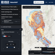
WaterMAP: Water Monitoring Above the Planet
WaterMAP, or Water Monitoring Above the Planet, is an interactive web application that brings together surface water observations across the U.S. The application allows users to explore water conditions over time using both remotely sensed satellite and field measured data.