
...to informing restoration efforts in the Florida Everglades
...to tracking storm-related flood conditions through the South Atlantic...
...to investigating coral health in the Florida Keys & Caribbean...
...to assessing environmental contaminants on aquatic life in the Mississippi River Basin...
...USGS science spans the South Atlantic, Gulf States and Caribbean
The Southeast Region includes 13 states and two U.S. territories, Puerto Rico and the U.S. Virgin Islands
The Southeast Region includes 13 states and two U.S. territories, Puerto Rico and the U.S. Virgin Islands
Southeast Region
We conduct impartial, multi- and interdisciplinary research and monitoring to address a broad range of natural-resource issues that affect the quality of life of citizens and landscapes in the Southeastern United States and the Caribbean region.
News
USGS: Lithium in Carolinas Could Replace Imports for a Century or More
USGS: Lithium in Carolinas Could Replace Imports for a Century or More
Lithium in Eastern States Could Replace Imports for a Century or More
Lithium in Eastern States Could Replace Imports for a Century or More
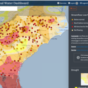
New Nationwide Tool Helps Answer: Do We Have Enough Water?
New Nationwide Tool Helps Answer: Do We Have Enough Water?
Publications
Methods for estimating selected low-flow frequency and mean annual flow statistics at gaged and ungaged locations on streams in Georgia, North Carolina, and South Carolina Methods for estimating selected low-flow frequency and mean annual flow statistics at gaged and ungaged locations on streams in Georgia, North Carolina, and South Carolina
The U.S. Geological Survey, in cooperation with the Georgia Department of Natural Resources (Environmental Protection Division), North Carolina Department of Environmental Quality (Division of Water Resources), North Carolina Department of Public Safety (Office of Recovery and Resiliency), and South Carolina Department of Environmental Services, updated low-flow frequency, mean annual...
Loss and transformation of coastal wetlands due to global change in the conterminous United States: Past, present, and future Loss and transformation of coastal wetlands due to global change in the conterminous United States: Past, present, and future
Coastal wetlands are being transformed by global change, impacting the ecological and societal benefits provided by these ecosystems. Synthesizing knowledge of historical and expected future transformations in coastal wetlands can help inform forward-looking planning and stewardship efforts. Here, we review anticipated future ecological transformations in coastal wetlands of the...
By
Ecosystems Mission Area, Water Resources Mission Area, California Water Science Center, Great Lakes Science Center, Pacific Coastal and Marine Science Center, St. Petersburg Coastal and Marine Science Center, Western Ecological Research Center (WERC), Woods Hole Coastal and Marine Science Center, Wetland and Aquatic Research Center , Eastern Ecological Science Center
Development of projected depth-duration-frequency curves for precipitation in Florida, 2020–59 and 2050–89 Development of projected depth-duration-frequency curves for precipitation in Florida, 2020–59 and 2050–89
The planning, permitting, and design of stormwater-management projects require estimates of the depths of extreme precipitation for current and future events with specified durations and return periods. In this project, precipitation data from six downscaled climate datasets were used to determine changes in precipitation depth-duration-frequency curves from the period 1966–2005 to the...
Science

Mobile River Basin Study
The Mobile River Basin in Alabama, Georgia, Mississippi, and Tennessee is one of the 59 study units that are part of the U.S. Geological Survey's National Water-Quality Assessment (NAWQA) Program. The long-term goals of this program are to describe the status and trends in the quality of a large, representative part of the Nation's surface- and ground-water resources, and to provide a sound...
South Atlantic Water Science Center Drought Monitoring
When rainfall is less than normal for several weeks, months, or years, the flow of streams and rivers declines, water levels in lakes and reservoirs fall, and the depth to water in wells increases. If dry weather persists and water-supply problems develop, the dry period can become a drought.

Triangle Area, NC, Water Supply Monitoring
The Research Triangle area, located within the upper Cape Fear and Neuse River basins, is one of the most rapidly developing areas in the Nation. Growth has increased demand for water from public suppliers, the majority of which draw water from streams and lakes in the region. Growth also brings the threat of greater loads of contaminants and new contaminant sources that, if not properly managed...