
Evaluation of Streamflow Depletion Related to Groundwater Withdrawal, Humboldt River Basin
This project evaluates how groundwater withdrawals affect streamflow in the Humboldt River Basin. It focuses on understanding the timing, magnitude, and causes of streamflow depletion, including agricultural pumping and mine dewatering, to support sustainable water management in Nevada.
The Humboldt River Basin is Nevada’s only major river basin entirely within the state. All its water comes from precipitation, so changes in climate have a big impact on the river and groundwater. Over time, development and groundwater pumping have added stress to the system. These withdrawals may be reducing river flows, but we don’t fully understand when and how much this happens.
Objectives
- Quantify streamflow depletion caused by groundwater withdrawals across the basin.
- Assess the role of mine dewatering and its contribution to changes in river flow.
- Improve understanding of timing and magnitude of impacts under varying climate conditions.
- Provide science-based guidance for water rights and resource management.
Approach
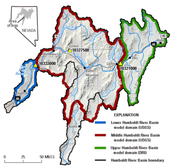
- Model Development: Build three regional-scale groundwater flow models:
- Upper Basin Model – Developed by the Desert Research Institute (DRI).
- Middle Basin Model – Developed by the U.S. Geological Survey (USGS).
- Lower Basin Model – Co-developed by USGS and DRI.
- Data Collection: Compile precipitation, streamflow, and groundwater pumping records from agricultural and mining operations.
- Hydrologic Analysis: Use MODFLOW-based models to simulate interactions between groundwater and surface water under past and future scenarios, including historical and projected conditions.
- Mine Dewatering Assessment: Evaluate how water removed during mining is returned to the river or nearby deposits and its net effect on streamflow.
- Hydrographic Area Evaluation: Analyze cumulative and annual effects of groundwater withdrawals from each hydrographic area by simulating existing pumping, creating scenarios that isolate each area, and comparing streamflow to a reference case. This will show the relative connection of the groundwater system to the Humboldt River.
- Scenario Testing: Simulate impacts over 10, 25, 50, and 100 years to understand long-term trends.
- Stakeholder Engagement: Share findings with water rights holders, state agencies, and local communities to support transparent decision-making.
Products
- Evaluation of bias associated with capture maps (USGS and DRI)
- Journal Article (Published)
- Groundwater Discharge from Phreatophyte Vegetation (DRI)
- State of Nevada Water Resources Bulletin No. 48 (Published)
- Data (Published)
- Upper Basin (DRI)
- State of Nevada Water Resources Bulletin No. 49 (Published)
- Model Application (Published)
- Middle Basin (USGS)
- USGS Professional Paper (In-Press)
- Model Application (USGS Data Release – Provisional)
- Lower Basin (USGS and DRI)
- USGS Scientific Investigations Report (Published)
- Model Application (USGS Data Release – Published)
- Lovelock Valley Aquifer Test (USGS Open-File Report – Published)
- Lovelock Valley Aquifer Test Data (USGS Data Release – Published)
- Model Capture Results across all basins (USGS Data Release – Provisional)
- Humboldt Capture Query Tool Web Application (USGS Web Tool – Provisional): Interactive tool for viewing capture model results across all models.

Science in the Humboldt River Basin
This project evaluates how groundwater withdrawals affect streamflow in the Humboldt River Basin. It focuses on understanding the timing, magnitude, and causes of streamflow depletion, including agricultural pumping and mine dewatering, to support sustainable water management in Nevada.
The Humboldt River Basin is Nevada’s only major river basin entirely within the state. All its water comes from precipitation, so changes in climate have a big impact on the river and groundwater. Over time, development and groundwater pumping have added stress to the system. These withdrawals may be reducing river flows, but we don’t fully understand when and how much this happens.
Objectives
- Quantify streamflow depletion caused by groundwater withdrawals across the basin.
- Assess the role of mine dewatering and its contribution to changes in river flow.
- Improve understanding of timing and magnitude of impacts under varying climate conditions.
- Provide science-based guidance for water rights and resource management.
Approach
- Model Development: Build three regional-scale groundwater flow models:
- Upper Basin Model – Developed by the Desert Research Institute (DRI).
- Middle Basin Model – Developed by the U.S. Geological Survey (USGS).
- Lower Basin Model – Co-developed by USGS and DRI.
- Data Collection: Compile precipitation, streamflow, and groundwater pumping records from agricultural and mining operations.
- Hydrologic Analysis: Use MODFLOW-based models to simulate interactions between groundwater and surface water under past and future scenarios, including historical and projected conditions.
- Mine Dewatering Assessment: Evaluate how water removed during mining is returned to the river or nearby deposits and its net effect on streamflow.
- Hydrographic Area Evaluation: Analyze cumulative and annual effects of groundwater withdrawals from each hydrographic area by simulating existing pumping, creating scenarios that isolate each area, and comparing streamflow to a reference case. This will show the relative connection of the groundwater system to the Humboldt River.
- Scenario Testing: Simulate impacts over 10, 25, 50, and 100 years to understand long-term trends.
- Stakeholder Engagement: Share findings with water rights holders, state agencies, and local communities to support transparent decision-making.
Products
- Evaluation of bias associated with capture maps (USGS and DRI)
- Journal Article (Published)
- Groundwater Discharge from Phreatophyte Vegetation (DRI)
- State of Nevada Water Resources Bulletin No. 48 (Published)
- Data (Published)
- Upper Basin (DRI)
- State of Nevada Water Resources Bulletin No. 49 (Published)
- Model Application (Published)
- Middle Basin (USGS)
- USGS Professional Paper (In-Press)
- Model Application (USGS Data Release – Provisional)
- Lower Basin (USGS and DRI)
- USGS Scientific Investigations Report (Published)
- Model Application (USGS Data Release – Published)
- Lovelock Valley Aquifer Test (USGS Open-File Report – Published)
- Lovelock Valley Aquifer Test Data (USGS Data Release – Published)
- Model Capture Results across all basins (USGS Data Release – Provisional)
- Humboldt Capture Query Tool Web Application (USGS Web Tool – Provisional): Interactive tool for viewing capture model results across all models.