
Engaging Indigenous Communities to Co-Design a Web Application to Protect Everglades Tree Islands
The USGS collaborated with the Miccosukee and Seminole Tribes to co-design a dashboard mock-up for a real-time web application that monitors tree island health in the Everglades.
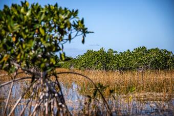
The Science Issue and Relevance: The Greater Everglades is a vast wetland ecosystem spanning two million acres, described as the “River of Grass” with water slowly moving southward from central Florida and emptying into Florida Bay. Tree islands, which are spatially separated elevated tree-covered mounds within the wetlands, are some of the most biodiverse and socio-culturally revered parts of the Everglades. Drier than the surrounding landscape, tree islands were used as the traditional homes of the Miccosukee and Seminole Tribes of Florida and contain their ancestral remains. Ongoing flooding and water management issues have resulted in the degradation and destruction of the Everglades tree islands. Prior to this initiative, there was no monitoring tool available to support water managers in protecting these sites.
Methodology for Addressing the Issue: The USGS collaborated with the Miccosukee Tribe of Indians of Florida and Seminole Tribe of Florida to co-design a dashboard for a web application that reports near-daily tree island flooding status. In a series of workshops and meetings, hydrologic indicators were selected that show near-daily and historical flooding status to indicate tree island health. Decision makers at the state and federal levels can use the Everglades Tree Island Indicator Web Application, called ETree (https://sofia.usgs.gov/eden/etree), to manage water flows and depths to protect these critical sites.
Future Steps: Next steps include additional refinements and functionality to ETree as needed, per feedback from the user community. Further refinements can enhance the assessment of tree island health, such as incorporating vegetation type, fires, and storm events, as well as expanding the dataset to include all tree islands.


The USGS collaborated with the Miccosukee and Seminole Tribes to co-design a dashboard mock-up for a real-time web application that monitors tree island health in the Everglades.
The Science Issue and Relevance: The Greater Everglades is a vast wetland ecosystem spanning two million acres, described as the “River of Grass” with water slowly moving southward from central Florida and emptying into Florida Bay. Tree islands, which are spatially separated elevated tree-covered mounds within the wetlands, are some of the most biodiverse and socio-culturally revered parts of the Everglades. Drier than the surrounding landscape, tree islands were used as the traditional homes of the Miccosukee and Seminole Tribes of Florida and contain their ancestral remains. Ongoing flooding and water management issues have resulted in the degradation and destruction of the Everglades tree islands. Prior to this initiative, there was no monitoring tool available to support water managers in protecting these sites.
Methodology for Addressing the Issue: The USGS collaborated with the Miccosukee Tribe of Indians of Florida and Seminole Tribe of Florida to co-design a dashboard for a web application that reports near-daily tree island flooding status. In a series of workshops and meetings, hydrologic indicators were selected that show near-daily and historical flooding status to indicate tree island health. Decision makers at the state and federal levels can use the Everglades Tree Island Indicator Web Application, called ETree (https://sofia.usgs.gov/eden/etree), to manage water flows and depths to protect these critical sites.
Future Steps: Next steps include additional refinements and functionality to ETree as needed, per feedback from the user community. Further refinements can enhance the assessment of tree island health, such as incorporating vegetation type, fires, and storm events, as well as expanding the dataset to include all tree islands.