
250K OnDemand Topo Cartographic Specifications - Map Symbol Guide
250K OnDemand Topo cartographic specifications Map Symbol Guide.
What is an OnDemand Topo map?
The 250K Topo map is a general purpose, digital topographic map that covers 1 degree of longitude by 2 degrees of latitude (an area of approximately 4,500 to 8,700 square miles) and is produced at a scale of 1:250,000. 250K Topo maps are one configuration of U.S. Geological Survey OnDemand Topo maps, which are free, customizable, topographic maps generated upon request using the topoBuilder web application (https://topobuilder.nationalmap.gov).
OnDemand Topo maps are intended for conventional map users, not for advanced GIS analysis. More information about OnDemand Topo maps and their use is available at https://www.usgs.gov/programs/national-geospatial-program/topoBuilder.
All OnDemand Topo maps are available in Portable Document Format (PDF) with geospatial extensions as well as a Tagged Image File Format (TIFF). PDF maps can be viewed and printed with any conforming PDF software. Versions 9.x and later of Adobe® Reader® and Acrobat® software provide access to the geospatial functionality of the OnDemand Topo map. Adobe Reader is available for free at https://get.adobe.com/reader.
Feature data is incorporated from national Geographic Information System (GIS) databases under the stewardship of The National Map (TNM). The large-scale data is generalized to the 1:250,000 scale for improved cartographic interpretation. Most data sources used are in the public domain and may be downloaded for free from The National Map download application (https://apps.nationalmap.gov/downloader).
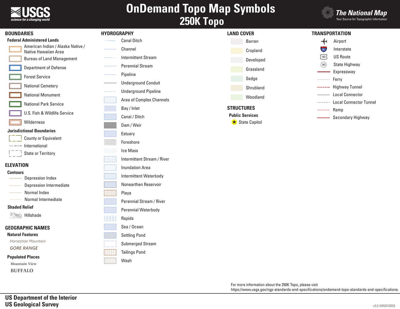
Base content represented in these maps are from The National Map geospatial data themes as follows:
- Transportation, including major roads and airports;
- Boundaries, both jurisdictional and administrative;
- Geographic names, including select natural features and populated places;
- Elevation, such as contours and shaded relief;
- Surface hydrography, such as lakes and rivers; and
- Selected land use classifications.
OnDemand Topo Map Symbols
Each map is made at a scale of 1:250,000 (one centimeter on the map represents 2500 meters or 2.5 kilometers on the ground), with selected features shown and emphasized by symbols and names. Map features may be represented as points, lines, or polygons depending on their size and extent. They incorporate different colors and patterns to distinguish between feature types and to show each feature’s importance.
Point symbols of different shapes and sizes depict small-extent features such as structures, dams, waterfalls, and wells. Point symbols may also depict small-extent features, such as state capitols. Linear map symbols (lines) of different colors and textures including straight, curved, solid, or dashed, represent features such as roads, rivers, and contours. Polygon features are usually the first features to be noticed on a topographic map and cover the map in some color or texture, sometimes having an outline to depict the areal extent. Polygon features include vegetation (green) or water (blue). Names and labels are shown in different fonts, sizes, and colors.
A unique feature of a topographic map is the contour. These lines do not exist on the Earth’s surface. They join points of equal elevation and therefore show heights of the land and reveal the shape of the land surface. Thicker brown lines are index contours and are labeled with the elevation they represent. Closely spaced contours indicate a steep land slope; widely spaced contours show more level ground. The elevation difference between adjacent contours is the contour interval. A map of a relatively flat area may have a contour interval of 10 feet. In steep areas an interval of 100 feet or more may be used to avoid coalescence or convergence of the contour lines. The contour interval is always noted in the map marginalia.
The cartographic representation of roads is based on functional classification defined as follows:
- Expressway1: A controlled access, divided arterial highway for through traffic.
- Secondary Highway1: Hard surface highways including secondary State routes, primary county routes, and other highways that connect principal cities and towns, and link these places with the primary highway system.
- Local Connector1: Hard surface roads not included in a higher class and improved, loose surface roads passable in all kinds of weather. These roads are adjuncts to the primary and secondary highway system and represent major arteries through populated places.
- Local Road1: Roads used primarily for local traffic.
- Four Wheel Drive Road1: Unimproved roads passable only with four-wheel drive vehicles.
1 Federal Highway Administration Planning Glossary - https://www.fhwa.dot.gov/planning/glossary/index.cfm