
The well-known statement "Earthquakes don't kill people, buildings do" highlights the need to make our communities more earthquake resilient. The impact of earthquakes on public safety and the national economy can be reduced through improvement of the built environment to resist earthquake effects such as ground shaking. Extending natural hazards science to risk involves (1) conducting research to develop and improve seismic hazard information and associated uncertainties for various building code applications, and (2) assessing seismic risk to the Nation’s buildings and other infrastructure to better communicate with stakeholders and promote seismic safety. Of the three broad areas of work prioritized by the Engineering and Risk Project (ERP), namely (1) earthquake monitoring, (2) hazard assessments, and (3) targeted research (Hayes and others, 2024), the ERP provides unique expertise to enhance the first two activities and plays a central role in targeted engineering research for earthquake risk reduction.
The Engineering and Risk Project (ERP) is part of the Hazards, Impact, and Risk (HIR) sub-committee of Science Coordination Committee (SCC) of the USGS Earthquake Hazards Program (EHP). Two ERP tasks are currently identified to extend hazard science to engineering mitigation and risk reduction (i.e., improve ability of built environment to resist hazards). They both have research and outreach elements and are consisted of:
Task 1: Collaboration with external engineers and National Seismic Hazard Model (NSHM) project on earthquake ground motions for construction codes; with five current subtasks:
Research on earthquake ground motion maps for construction codes
Adoption of USGS earthquake hazard assessments into construction codes
Development of web services and data releases for dissemination of earthquake ground motion maps for construction codes
Simulation, validation, and utilization of earthquake ground motion time-series for building codes
Alternative ground motion intensity measures
Task 2: Extending natural hazards to risk; with five subtasks:
Seismic risk to critical infrastructure
Earthquake-induced ground failure forecasts
Earthquake ground-motion and impact scenarios
Multi-hazard risk assessment
Seismic safety of tall buildings and other long-period structures
These tasks and subtasks have been designed to collaborate with the internal community (e.g., the USGS NSHM Project, the USGS National Earthquake Information Center (NEIC)) to develop requisite data, methods, and tools for assessing risks to building and non-building infrastructure systems. The goals are achieved by collaborating with the external community (e.g., Building Seismic Safety Council (BSSC), Federal Emergency Management Agency (FEMA)) to assess design loads and mitigate seismic risk.
For More Information
References:
Hayes, G.P., Baltay Sundstrom, A.S., Barnhart, W.D., Blanpied, M.L., Davis, L.A., Earle, P.S., Field, N., Franks, J.M., Given, D.D., Gold, R.D., Goulet, C.A., Guy, M.M., Hardebeck, J.L., Luco, N., Pollitz, F., Ringler, A.T., Scharer, K.M., Sobieszczyk, S., Thomas, V.I., and Wolfe, C.J., 2024, U.S. Geological Survey Earthquake Hazards Program decadal science strategy, 2024–33: U.S. Geological Survey Circular 1544, 55 p., Link
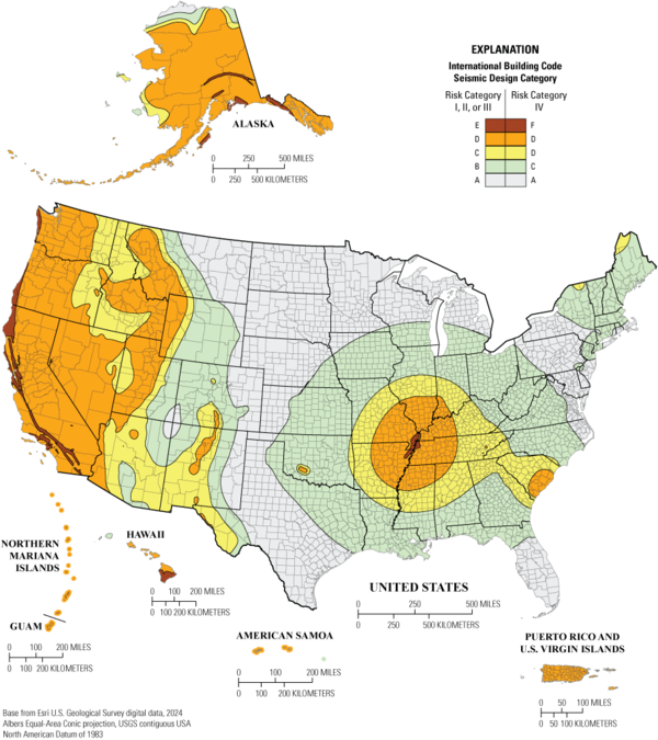
Federal Emergency Management Agency [FEMA], 2020b, NEHRP recommended seismic provisions—Seismic design category maps for 2024 International Residential Code (IRC) and International Building Code (IBC): Federal Emergency Management Agency report no. FEMA P-2192-4, 32 p., Link
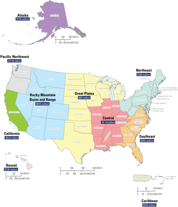
Jaiswal, K., Rozelle, J.,Tong, M.,Sheehan, A.,McNabb, S.,Kelly, M.,Zuzak, C.,Bausch, D., and Sims, J., 2023, Hazus estimated annualized earthquake losses for the United States: Federal Emergency Management Agency report no. FEMA P-366, 98 p., Link
Jaiswal, K.S., Rezaeian, S., Luco, N., Kwong, N.S., Makdisi, A.J., Mason, H.B., Chase, R.E., and Kortum, Z.A., 2025, Engineering and risk research—A strategic vision for extending USGS earthquake science to risk assessment and mitigation: U.S. Geological Survey Circular 1555, 19 p., Link
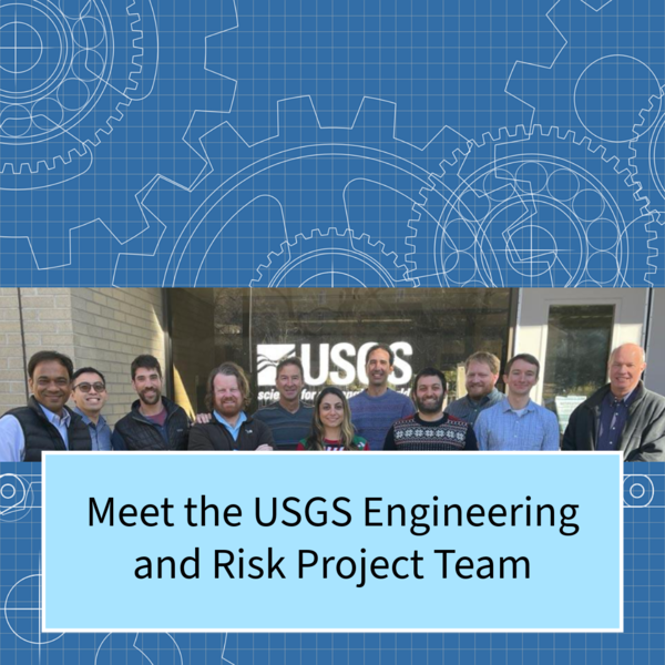

Engineering and Risk Project Team
Engineering and Risk Project Team: from left to right, Kishor Jaiswal, N. Simon Kwong, Rob Chase, Ben Mason, David Wald, Sanaz Rezaeian, Nico Luco, Andrew Makdisi, Eric Thompson, Zachary Kortum, Mark Peterson.

What are the earthquake hazards/risks where I live? What are the earthquake hazards/risks where I live?
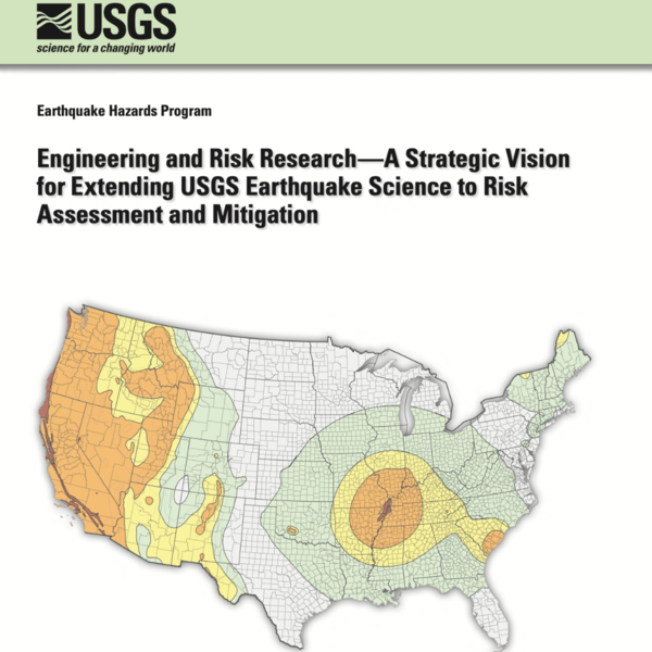
Determining your risk with regard to earthquakes, or more precisely shaking from earthquakes, isn't as simple as finding the nearest fault. The chances of experiencing shaking from an earthquake and/or having property damage is dependent on many different factors. The National Hazard Maps use all available data to estimate the chances of shaking (of different strengths and frequencies) across the...

How do I decide whether or not to get earthquake insurance? How do I decide whether or not to get earthquake insurance?
You should consider the following factors when deciding whether or not to get earthquake insurance: proximity to active earthquake faults seismic history of the region (frequency of earthquakes) time since last earthquake building construction (type of building and foundation) architectural layout materials used quality of workmanship extent to which earthquake resistance was considered by the...

How do earthquakes affect buildings? How do earthquakes affect buildings?
Ground shaking is the primary cause of earthquake damage to man-made structures. Many factors influence the strength of earthquake shaking at a site including the earthquake's magnitude, the site's proximity to the fault, the local geology, and the soil type. More than 250 structures throughout the United States have been outfitted with seismic sensors by the USGS National Strong Motion Project...
The well-known statement "Earthquakes don't kill people, buildings do" highlights the need to make our communities more earthquake resilient. The impact of earthquakes on public safety and the national economy can be reduced through improvement of the built environment to resist earthquake effects such as ground shaking. Extending natural hazards science to risk involves (1) conducting research to develop and improve seismic hazard information and associated uncertainties for various building code applications, and (2) assessing seismic risk to the Nation’s buildings and other infrastructure to better communicate with stakeholders and promote seismic safety. Of the three broad areas of work prioritized by the Engineering and Risk Project (ERP), namely (1) earthquake monitoring, (2) hazard assessments, and (3) targeted research (Hayes and others, 2024), the ERP provides unique expertise to enhance the first two activities and plays a central role in targeted engineering research for earthquake risk reduction.
The Engineering and Risk Project (ERP) is part of the Hazards, Impact, and Risk (HIR) sub-committee of Science Coordination Committee (SCC) of the USGS Earthquake Hazards Program (EHP). Two ERP tasks are currently identified to extend hazard science to engineering mitigation and risk reduction (i.e., improve ability of built environment to resist hazards). They both have research and outreach elements and are consisted of:
Task 1: Collaboration with external engineers and National Seismic Hazard Model (NSHM) project on earthquake ground motions for construction codes; with five current subtasks:
Research on earthquake ground motion maps for construction codes
Adoption of USGS earthquake hazard assessments into construction codes
Development of web services and data releases for dissemination of earthquake ground motion maps for construction codes
Simulation, validation, and utilization of earthquake ground motion time-series for building codes
Alternative ground motion intensity measures
Task 2: Extending natural hazards to risk; with five subtasks:
Seismic risk to critical infrastructure
Earthquake-induced ground failure forecasts
Earthquake ground-motion and impact scenarios
Multi-hazard risk assessment
Seismic safety of tall buildings and other long-period structures
These tasks and subtasks have been designed to collaborate with the internal community (e.g., the USGS NSHM Project, the USGS National Earthquake Information Center (NEIC)) to develop requisite data, methods, and tools for assessing risks to building and non-building infrastructure systems. The goals are achieved by collaborating with the external community (e.g., Building Seismic Safety Council (BSSC), Federal Emergency Management Agency (FEMA)) to assess design loads and mitigate seismic risk.
For More Information
References:
Hayes, G.P., Baltay Sundstrom, A.S., Barnhart, W.D., Blanpied, M.L., Davis, L.A., Earle, P.S., Field, N., Franks, J.M., Given, D.D., Gold, R.D., Goulet, C.A., Guy, M.M., Hardebeck, J.L., Luco, N., Pollitz, F., Ringler, A.T., Scharer, K.M., Sobieszczyk, S., Thomas, V.I., and Wolfe, C.J., 2024, U.S. Geological Survey Earthquake Hazards Program decadal science strategy, 2024–33: U.S. Geological Survey Circular 1544, 55 p., Link
Federal Emergency Management Agency [FEMA], 2020b, NEHRP recommended seismic provisions—Seismic design category maps for 2024 International Residential Code (IRC) and International Building Code (IBC): Federal Emergency Management Agency report no. FEMA P-2192-4, 32 p., Link
Jaiswal, K., Rozelle, J.,Tong, M.,Sheehan, A.,McNabb, S.,Kelly, M.,Zuzak, C.,Bausch, D., and Sims, J., 2023, Hazus estimated annualized earthquake losses for the United States: Federal Emergency Management Agency report no. FEMA P-366, 98 p., Link
Jaiswal, K.S., Rezaeian, S., Luco, N., Kwong, N.S., Makdisi, A.J., Mason, H.B., Chase, R.E., and Kortum, Z.A., 2025, Engineering and risk research—A strategic vision for extending USGS earthquake science to risk assessment and mitigation: U.S. Geological Survey Circular 1555, 19 p., Link
Engineering and Risk Project Team
Engineering and Risk Project Team: from left to right, Kishor Jaiswal, N. Simon Kwong, Rob Chase, Ben Mason, David Wald, Sanaz Rezaeian, Nico Luco, Andrew Makdisi, Eric Thompson, Zachary Kortum, Mark Peterson.
What are the earthquake hazards/risks where I live? What are the earthquake hazards/risks where I live?
Determining your risk with regard to earthquakes, or more precisely shaking from earthquakes, isn't as simple as finding the nearest fault. The chances of experiencing shaking from an earthquake and/or having property damage is dependent on many different factors. The National Hazard Maps use all available data to estimate the chances of shaking (of different strengths and frequencies) across the...
How do I decide whether or not to get earthquake insurance? How do I decide whether or not to get earthquake insurance?
You should consider the following factors when deciding whether or not to get earthquake insurance: proximity to active earthquake faults seismic history of the region (frequency of earthquakes) time since last earthquake building construction (type of building and foundation) architectural layout materials used quality of workmanship extent to which earthquake resistance was considered by the...
How do earthquakes affect buildings? How do earthquakes affect buildings?
Ground shaking is the primary cause of earthquake damage to man-made structures. Many factors influence the strength of earthquake shaking at a site including the earthquake's magnitude, the site's proximity to the fault, the local geology, and the soil type. More than 250 structures throughout the United States have been outfitted with seismic sensors by the USGS National Strong Motion Project...