
Landsat at Work: USGS Informing Domestic Lithium Development
Chances are, most people reading this story are using a device powered by a lithium-ion battery. Lithium is best known for powering batteries in phones, laptops, and electric vehicles, but it’s also used in lightweight metals, ceramics, lubricants, and even some medications.

Expanding responsible domestic production is a priority to bolster national security, reduce reliance on foreign supply chains and create high-quality American jobs.
That’s where the U.S. Geological Survey and its Landsat satellite program, managed in partnership with NASA, comes in. For more than 50 years, Landsat has provided continuous Earth observation data to support science-based decision-making. These images, available at no cost to the public, help land managers, scientists and industry leaders understand how landscapes change over time. This information can inform many decisions, including agriculture, conservation, and mine planning in sensitive environments.
The United States ranks third globally in known lithium resources. Efforts are underway to expand production of this essential mineral in ways that meet environmental standards and land stewardship goals. Responsible mining development depends on accurate information about the land and water in areas targeted for mining.
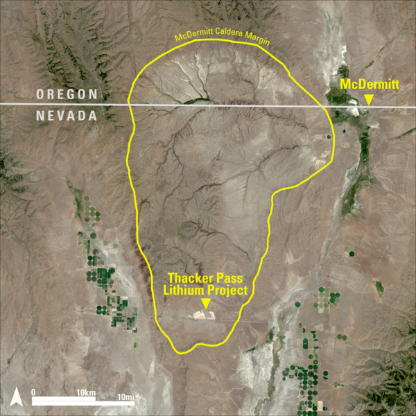
Landsat data can be used to estimate groundwater depth and assess vegetation near potential mine sites, which are two key factors in environmental impact assessments. A recent example of this application is the Thacker Pass project in Northern Nevada’s Humboldt County, where lithium is plentiful but water is scarce.
“Landsat imagery is valuable for critical minerals project development because it provides consistent, long-term data that document land use changes and geological features, assess environmental receptors and support planning decisions,” said Alexi Zawadzki, president of North American operations and vice president of resource development for Lithium Americas. “Its resolution and multispectral data enable accurate analysis of vegetation, water resources, and terrain features, aiding sustainable and informed development.”
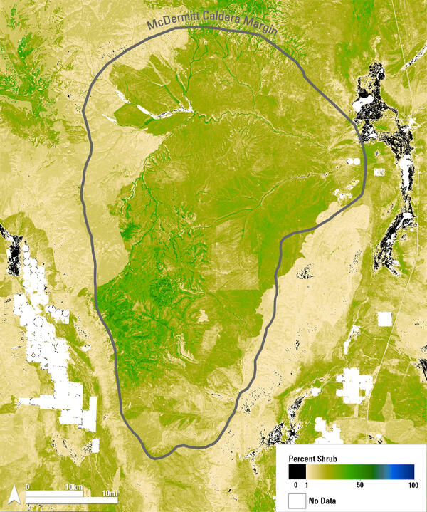
Landsat aids in mine site selection
The U.S. Bureau of Land Management and the State of Nevada both require sage-grouse habitat considerations in mine permit applications. While the sage-grouse is not a protected bird, its population declined more than 80% from 1965 to 2019, according to a USGS report. Rangeland managers use the birds as an indicator of health in sagebrush environments; if the bird is doing well, so is the landscape.
Project developers studied a broad area in Nevada using Landsat data and found the initial site planned for the mine was prime sage-grouse territory, so they moved the mine location six miles south to Thacker Pass, an area less suitable for sage-grouse, according to Lucas Phipps, a rangeland ecologist at the University of Nevada, Reno.
As part of its restoration planning, Lithium Americas created the Great Basin Sagebrush Restoration Fund at UNR. The fund uses data from Landsat-based products like the USGS Rangeland Condition Monitoring and Projection project to evaluate rangeland vegetation. This project estimates the percentage of 10 land cover types, such as sagebrush, bare ground, and tree cover, for each Landsat pixel across the western U.S. and the Great Plains.
Large-scale vegetation data and habitat modeling are important for mine planning because they help land managers understand how wildlife interacts with the landscape.
“The RCMAP products derived from Landsat imagery, coupled with our year-round telemetry locations of sage-grouse, are among the most valuable spatial layers used to model habitat suitability across different life-history stages, such as nesting,” said Peter Coates, a USGS supervisory research wildlife biologist. “These products help inform projects related to lithium mining in Nevada, helping managers make decisions with the best available science.”
Although mining operations have not yet begun at Thacker Pass, restoration efforts are already underway to improve the sagebrush ecosystem. Plans call for ongoing reclamation throughout the life of the mine.
“If we can reclaim our land faster, that’s better for the environment, better for sage-grouse, and it’s also better for all wildlife in general,” said Jennifer Schonlau, manager of sustainability and environmental engineering for Lithium Americas.
Landsat Aids in Groundwater Analysis
Mining activities can impact local groundwater levels. That is why groundwater assessment is the second key element in evaluating new mine sites. To meet regulations, the Thacker Pass mine plans to reuse process water multiple times before disposal.
“We will be a zero liquid discharge facility, so we will not send any industrial wastewater into the environment,” Schonlau said. “Every drop of water will be reused roughly seven times throughout the process.”
The planned Thacker Pass operation will also be one of the first to extract lithium from clay-based sources, rather than conventional large evaporation ponds. Most of the water will be removed from leftover materials, called tailings, which will then be stored in a dry facility and later used to help reclaim the site.
“There’s still concern about water consumption, so looking at that across the basin was very important in a historically agriculturally dominated watershed,” Phipps said.
In a recent report, Phipps and colleagues used Landsat to look at vegetation and USGS well data to estimate groundwater levels. Some plants use only surface water, while others with deep roots rely on groundwater. The results showed the mine’s planned water use would meet regulatory standards. While Landsat provides important insight into vegetation and groundwater conditions, field checks and continued monitoring remain essential to managing long-term impacts.
Economic and supply chain benefits
Landsat supports decision-making across many industries and delivers durable economic value. In Nevada, construction and operations associated with lithium development are projected to support American jobs and local communities, while strengthening domestic supply chains. In Nevada, mine construction is already benefiting local communities. According to estimates, construction of Thacker Pass could generate more than \$700 million annually and support 1,800 jobs. A study by the University of Nevada, Reno Extension estimates economic activity will average \$2.1 billion per year once mining begins.
Thacker Pass is just one example of Landsat’s value to America’s economy. A 2023 economic valuation report of Landsat calculated its total annual contributions at \$25.6 billion. Benefits included \$255 million in increased gold discoveries, \$300 million in savings for farmers through reduced flood insurance premiums, and \$41 million in value from patents citing Landsat data.
As lithium becomes more essential to daily life, the need for transparent, science-based planning grows.
“I’m carrying a brick of lithium in my pocket,” Phipps said. “We all carry these around, and our laptops and all of our devices are lithium-powered. We’re all contributing to the consumption of that resource, and so we’re all responsible for the ethical and appropriate production.”
Development at Thacker Pass is one example of how Landsat can support regulatory compliance and resource planning. As the nation advances Energy Dominance with American-made supply chains, Landsat’s role in assessing rangeland health, water availability and land-use impacts will remain critical to responsible development under U.S. standards. Landsat’s role in assessing rangeland health, water availability, and land use impacts will remain critical as the nation works to balance energy independence with responsible land stewardship.
Disclaimer: This web page contains hypertext links to information created and maintained by other organizations. USGS is not responsible for the content of any off-site pages. Reference herein to any specific commercial products, processes, or services by trade name, trademark, manufacturer, or otherwise, does not constitute or imply its endorsement or recommendation by the United States Government.
Related
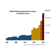
Global lithium production from mines in millions of tons
Chart that shows global lithium production from mines in millions of tons. In 2023, over 10 times as much lithium was produced from mines than in 2003. This increase in production reflects the rising demand for lithium.
Related
Global lithium production from mines in millions of tons
Chart that shows global lithium production from mines in millions of tons. In 2023, over 10 times as much lithium was produced from mines than in 2003. This increase in production reflects the rising demand for lithium.