
Meet the Autonomous MAPping CATaraft, or Autonomous MAPCAT
By Coastal and Marine Hazards and Resources Program
September 19, 2025
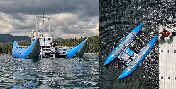
The Autonomous MAPCAT is a USGS-designed vessel that can be used to transport any number of scientific packages at, or just below, the air-water interface. The equipment can then be accurately navigated along a user configurable survey route. Scientific instrument packages can include a multi-camera system, sonar mapping equipment, or chemical sensors, for example.
Media
Sources/Usage: Public Domain. View Media Details
The vehicle is a remotely controlled, 14-foot-long by 7-foot-wide boat, built from an inflatable pontoon, aluminum frame, whitewater cataraft. It is propelled with a 6 HP electric outboard motor and can be accurately navigated at speeds between 1.3 - 4.2m/s (~2.5-8) knots. It operates best in winds of 15kt or less and seas less than 2 ft but can be operated successfully somewhat outside of those limits. At a survey speed of 1.4 m/s (2.7kts) it can survey continuously for approximately 4 hours or longer on a single charge, payload dependent. The vessel has a total capacity of approximately 800 pounds approximately 300 pounds are available for the scientific package. It includes a survey grade GNSS coupled with a powerful autopilot which enables accurate and entirely autonomous survey operation. A live video camera feed is provided to the operator from a fixed camera that can be pointed in any director or part of the vessel before launch. The Autonomous MAPCAT can be entirely disassembled and deflated for shipping or transported intact with a trailer. Its assembled weight before adding a payload is approximately 300 lbs.
The Autonomous MAPCAT is designed with a large 3’x3’ payload “bay” at the front of the vessel between the pontoons which can be used to transport any number of scientific packages at, or just below, the air-water interface. The equipment can then be accurately navigated along a user configurable survey route. Example scientific instrument packages can include a multi-camera system, sonar mapping equipment, or chemical sensors. The vessel is designed to be payload agnostic and therefore the payload package must be mostly self-contained, including its own power. There is minimal interface capability for simple operations, however, such as raising and lowering the package into the water and switching an instrument system on or off with a remotely operated relay switch controlled by the operator, or triggered automatically during the autonomous mission plan.
This effort was partially funded by the Department of Defense's Defense Advanced Research Projects Agency (DOD-DARPA), as part of a collaborative project aimed at protecting DoD coastal infrastructure and personnel by mitigating damage related to coastal flooding and erosion.
Related

PCMSC Marine Facility (MarFac)
Learn about the USGS Pacific Coastal and Marine Science Center Marine Facility, or MarFac.
Related
PCMSC Marine Facility (MarFac)
Learn about the USGS Pacific Coastal and Marine Science Center Marine Facility, or MarFac.