
Morphodynamics of dune-based coastal flood mitigation under sea-level rise
Process-based modeling focuses on two beaches in Santa Cruz County
Process-based modeling focuses on two beaches in Santa Cruz County
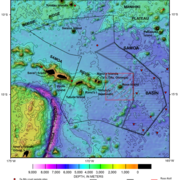
A mid-ocean ridge revealed by 3D magnetic modeling
Study presents new geologic map of Escanaba Trough
Study presents new geologic map of Escanaba Trough
Waves, not just runoff, drive sediment buildup on American Samoa coral reefs
Great Salt Lake sediments record thousands of years of earthquake history
USGS study investigates how sediments respond to surface rupture and earthquake shaking
USGS study investigates how sediments respond to surface rupture and earthquake shaking
New high-resolution geophysics in the Outer California Borderland
Data reveal repeated episodes of slope failure and earthquake activity over last 750,000 years
Data reveal repeated episodes of slope failure and earthquake activity over last 750,000 years
USGS Scientist Contributes to World Ocean Assessment
United Nations scientific report assesses state of the global ocean
United Nations scientific report assesses state of the global ocean
USGS leads deep-sea sampling expedition in the Samoan Basin
Interagency effort with NOAA, BOEM to map and characterize abyssal seafloor offshore American Samoa
Interagency effort with NOAA, BOEM to map and characterize abyssal seafloor offshore American Samoa
Tracking sediment erosion and transport in a reef-adjacent watershed
New research focuses on the Río Loco watershed and Bahía de Guánica, Puerto Rico
New research focuses on the Río Loco watershed and Bahía de Guánica, Puerto Rico
USGS Releases Global 3D Archive of Coral Reef Cores to Support Climate and Coastal Research
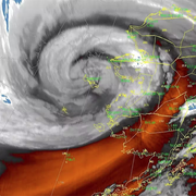
Linking climate variability to shoreline change in the Pacific Northwest
Ozette Lake: A natural seismograph along the northern Cascadia Subduction Zone (Video)
Pacific Coastal and Marine Science Center
PCMSC is one of three centers serving the mission of the USGS Coastal and Marine Hazards and Resources Program—the primary Federal marine geology and physical science research program responsible for the Nation’s entire coastal and marine landscape.
What We Do: Coastal and Marine Science at USGS Santa Cruz
What We Do: Coastal and Marine Science at USGS Santa Cruz

Get an overview of the coastal and marine research conducted by the USGS in Santa Cruz, California in our downloadable booklet.
Research Projects
Research Projects

Read about our science projects, find out where we are working, and discover the reasons why our research matters.
News
Morphodynamics of dune-based coastal flood mitigation under sea-level rise
Morphodynamics of dune-based coastal flood mitigation under sea-level rise
A mid-ocean ridge revealed by 3D magnetic modeling: New geologic map of Escanaba Trough
A mid-ocean ridge revealed by 3D magnetic modeling: New geologic map of Escanaba Trough
Waves, not just runoff, drive sediment buildup on American Samoa coral reefs
Waves, not just runoff, drive sediment buildup on American Samoa coral reefs
Publications
Tectonic controls on volcanism and associated hydrothermal activity in a sediment-dominated mid-ocean ridge; Escanaba Trough Tectonic controls on volcanism and associated hydrothermal activity in a sediment-dominated mid-ocean ridge; Escanaba Trough
Mid-ocean ridges, the Earth's most extensive volcanic system, exhibit unique characteristics in sediment-dominant environments. Thick sediment cover insulates the crust and channels fluid along pathways that can lead to the formation of distinct crustal alteration patterns, exceptionally large mineral deposits, and specialized chemosynthetic ecosystems. This study presents an...
Loss and transformation of coastal wetlands due to global change in the conterminous United States: Past, present, and future Loss and transformation of coastal wetlands due to global change in the conterminous United States: Past, present, and future
Coastal wetlands are being transformed by global change, impacting the ecological and societal benefits provided by these ecosystems. Synthesizing knowledge of historical and expected future transformations in coastal wetlands can help inform forward-looking planning and stewardship efforts. Here, we review anticipated future ecological transformations in coastal wetlands of the...
By
Ecosystems Mission Area, Water Resources Mission Area, Coastal and Marine Hazards and Resources Program, California Water Science Center, Eastern Ecological Science Center, Great Lakes Science Center, Pacific Coastal and Marine Science Center, St. Petersburg Coastal and Marine Science Center, Western Ecological Research Center (WERC), Wetland and Aquatic Research Center , Woods Hole Coastal and Marine Science Center
Science
Typhoon Merbok Disaster Recovery Project: Accomplishments
The Typhoon Merbok Disaster Emergency Recovery Efforts project addresses critical data and capacity gaps in coastal Alaska by generating high resolution environmental datasets, hazard analyses, and monitoring tools needed to quantify erosion, flooding, and permafrost-related risks at the community scale.

Geologic Mapping for Landscape Resiliency in California, Oregon, and Washington
This project uses geologic and geomorphic mapping in the context of societally relevant problems in the Earth’s critical zone. Leveraging interdisciplinary research ties and interagency collaborations, it utilizes remote sensing data, corroborated with field observations, to determine i) the spatial distribution of geomorphic processes and ages of Quaternary deposits in the context of active...
By
Earthquake Hazards Program, Landslide Hazards Program, National Cooperative Geologic Mapping Program, Earthquake Science Center, Geologic Hazards Science Center, Geology, Minerals, Energy, and Geophysics Science Center, Geosciences and Environmental Change Science Center, Pacific Coastal and Marine Science Center, Big Sur Landslides
American Samoa Mapping Project
USGS scientists are leading a sampling effort to the Samoa Basin, offshore of American Samoa. This work is part of an interagency-supported three-month hydrograph survey project led by NOAA and in partnership with BOEM.