
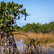
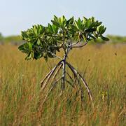
Everglades
Everglades
Filter Total Items: 50

Invasive Burmese python research in the Greater Everglades
USGS leads federal research to control the highly invasive Burmese python ( Python bivittatus), which has become firmly established across the Greater Everglades Ecosystem and poses a serious threat to native wildlife. Capable of reaching over 17 feet long, this massive constrictor is believed to be a key factor in the sharp decline of mammal populations in the region. For over a decade...
Engaging Indigenous Communities to Co-Design a Web Application to Protect Everglades Tree Islands
The USGS collaborated with the Miccosukee and Seminole Tribes to co-design a dashboard mock-up for a real-time web application that monitors tree island health in the Everglades.
Developing a Roadmap for the Future of Natural Resources in Everglades National Park
To sustain economic and ecologically viable ecosystems into the future, USGS is developing freshwater delivery targets for water flowing southward into Everglades National Park by integrating climate and sea level projections, hydrologic modeling, and ecological modeling to forecast ecosystem responses to future freshwater availability scenarios.
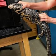
Early detection and rapid response tools for invasive tegu lizards
Scientists at USGS have shown that much of the US is suitable for invasion by tegu lizards, and suitability will likely increase in the future. While tegus can be removed via trapping, it is difficult to monitor every geographic area where tegus could invade. Thus, methods for quickly detecting and removing tegus in new areas are the best way to prevent spread and minimize damage from these...

Seagrass Beds and Manatee Foraging Areas in the Ten Thousand Islands: Mapping and Characterizing by Incorporating Manatee GPS Tracking Data and Habitat Information
Turbid water conditions make the delineation and characterization of benthic habitats difficult by traditional in situ and remote sensing methods. Consequently, only a small fraction of this valuable resource has been mapped or characterized.

Decision Support Tools for Everglades Ecosystem-Based Management
The USGS Joint Ecosystem Modeling team will work with partners to identify and develop decision support tools for Everglades water management.

Evaluating Population Viability and Habitat Suitability for the Cape Sable Seaside Sparrow Under Future Climate and Management Conditions
WARC will assess Cape Sable seaside sparrow population response and viability under different management and habitat change scenarios. The USGS EverSparrow model will be run on future scenarios, and differences in the predicted probability of presence and the efficacy of varying conservation strategies will be evaluated.

Burmese Python Environmental DNA (eDNA) Surveys in the Stormwater Treatment Areas and Corkscrew Regional Ecosystem Watershed
USGS scientists have developed and optimized python-specific eDNA markers to detect Burmese pythons from water samples taken from the Florida Everglades. This development may aid in the identification of possible waterways used as corridors for northward expansion of this invasive species.

Invasive Burmese Pythons in Southern Florida
Invasive species represent a significant threat to global biodiversity and a substantial economic burden to surrounding communities. In the last 40 years, the Burmese python ( Python bivittatus) has invaded southern Florida, including Everglades National Park, Big Cypress National Preserve, and other protected lands.
Multi-year Burmese Python Vital Rate Research Collaborative in the Greater Everglades
USGS researchers will track juvenile Burmese python within Big Cypress National Preserve (BICY) and collect data on snake growth, habitat use, and causes of mortality. Known-fate models will be used to estimate survival and better understand factors that influence survival.

Ecological Modeling for the Central Everglades Planning Project (CEPP) Operational Plan
The Joint Ecosystem Modeling team will run a suite of 13 ecological models to provide insight into alternative restoration plans' ecological performance, unintended ecological conditions, and potential conflicts with other Comprehensive Everglades Restoration Plan (CERP) goals.

Adding an Aquatic Prey Fish Module within the Everglades Vulnerability Analysis Modeling Framework
The USGS Joint Ecosystem Modeling team will use Bayesian networks to build a spatially explicit Everglades Vulnerability Analysis module based on current knowledge and existing data on fish density and biomass trends on the landscape.