
The testimonials below demonstrate the impact of recent geologic mapping projects carried out by the GLGMC.
3D Viewer Enhances Stakeholders’ Understanding and Communication of Geology
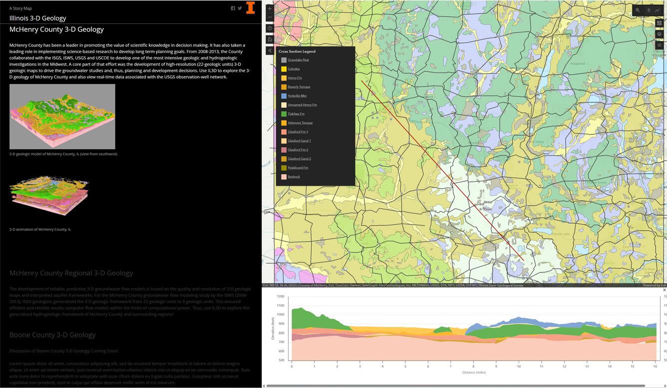
The Illinois State Geological Survey (ISGS) has recently developed a public 3D interface for geological data. Stakeholders have requested tools to enhance the communication and illustration of geologic data, as well as support data queries and ordinances. Printed maps can sometimes limit the full understanding of sediment frameworks below the Earth’s surface. The 3D viewer created by ISGS allows the user to rapidly access subsurface information in a location of their choice in only a few clicks. In McHenry County, water levels in monitoring wells have been declining, and information from the GLGMC-derived 3D geological models were used to confirm the issue and begin discussions between local officials, developers and residents. Water resource managers successfully supported a county ordinance to protect a sensitive water supply by using the interface to effectively present critical information.
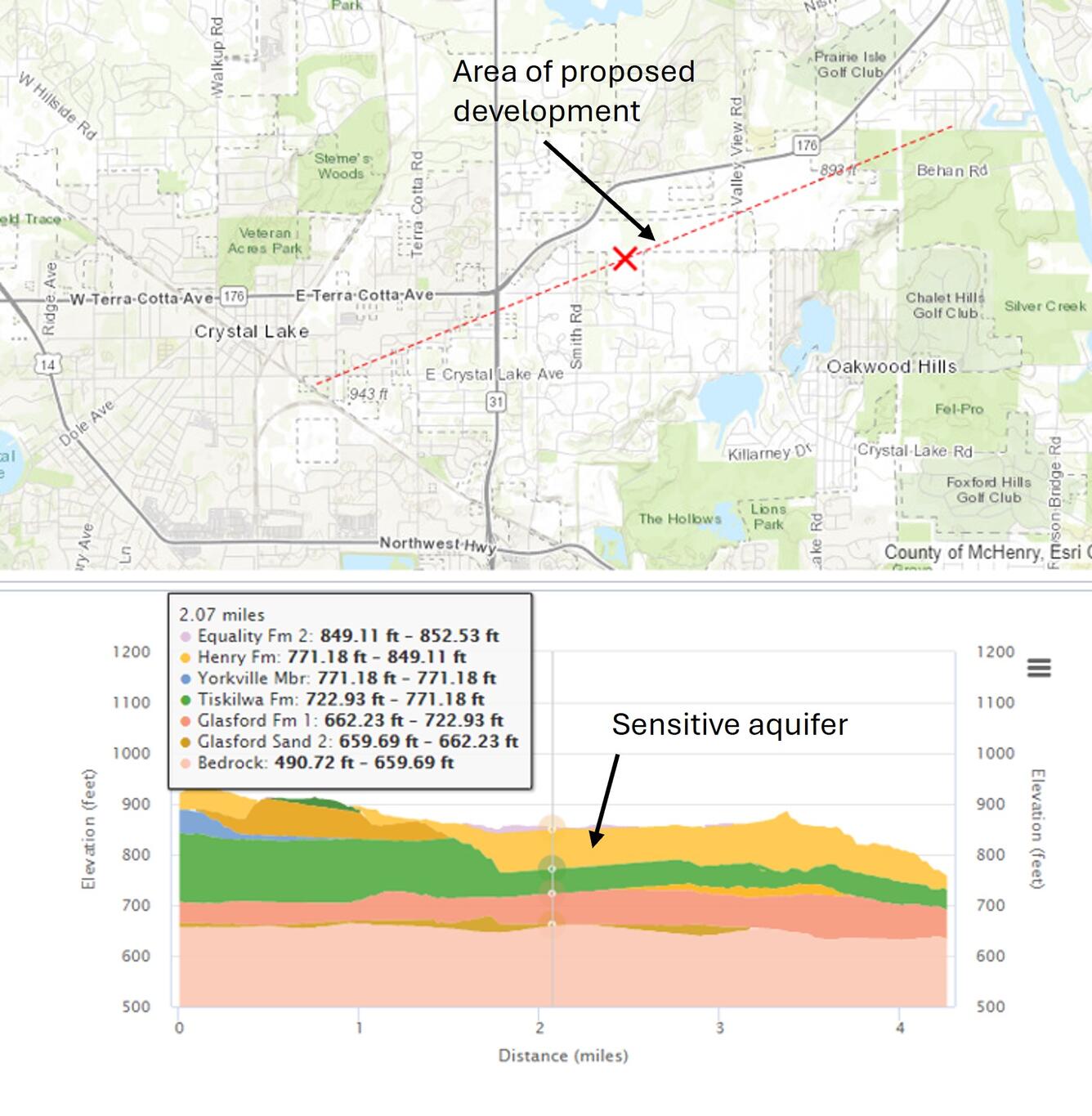
The image above shows a cross section created in the 3D viewer that was used to quickly assess the extent of an aquifer within a proposed area of development. One stakeholder remarked of the 3D viewer:
“I can’t do my job without it.”
The recently developed viewer has been used by engineers, consulting firms and even the Illinois Department of Transportation. It has become an essential tool for geotechnical data queries and conducting background research. Other users of the viewer have said that they
“much prefer the viewer over static maps”
and that even better than a picture, it is
“worth more than 1000 words!”
The monitoring wells in McHenry County that were used in this study are part of the U.S. Geological Survey's National Groundwater Monitoring Network. Using data from these wells in concert with models developed with the GLGMC derived 3D viewer is a shining example of the continued state and federal collaboration that embodies the integrated science effort that is the foundation of the Coalition.
Geologic Maps Help a Minnesota City Save Big!
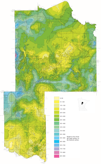
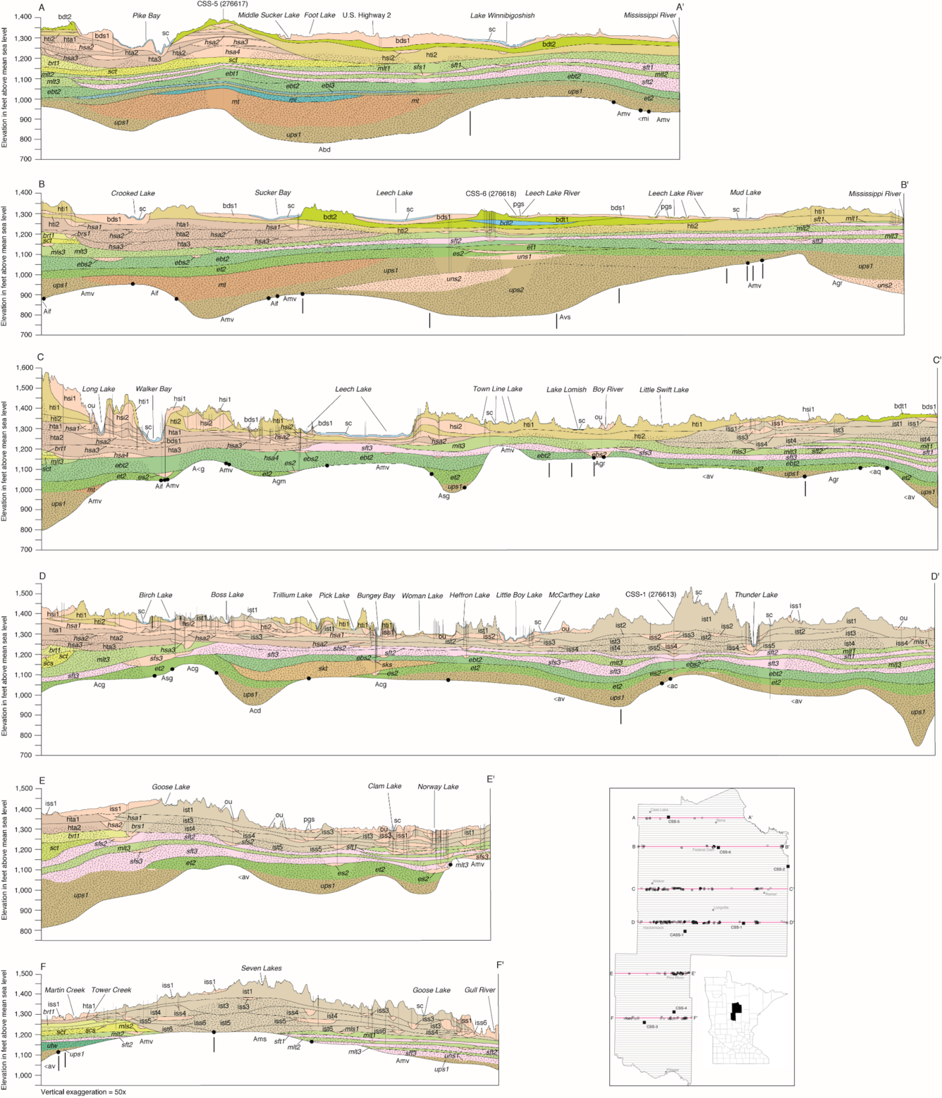
The Minnesota Geological Survey (MGS) is carrying out a project called the County Geologic Atlas (CGA) program to inform statewide groundwater management, mineral resource, and civil engineering applications. The 1-kilometer cross sections seen here were published by the MGS as part of the CGA effort and help identify and model subsurface sand bodies that may serve as aquifers. The Minnesota Department of Natural Resources (DNR) has been partnering with the MGS on CGA reports since 1995. The geologic information provided in the MGS’s reports is utilized by the DNR to provide additional information on the groundwater conditions and pollution sensitivity of aquifers. Recently, the City of Motley in Cass County, Minnesota used subsurface information provided by MGS to identify a suitable location for a municipal water well. This depth-to-bedrock map is another of may products published by MGS as part of the Cass County CGA.
The data collected through an initial GLGMC investment of around \$50,000 helped the city save more than \$700,000 in well-drilling costs. Additionally, MGS cross sections from the Washington County Geologic Atlas have been used to model groundwater flow as part of remediation efforts associated with aquifer contamination.
Mapping an Ancient River Valley Across State Boundaries
Beginning in 2019, the Ohio Department of Natural Resources, Division of Geological Survey and Indiana Geological and Water Survey identified a cross-state need to characterize a regional section of the buried Teays-Mahomet (Teays) River Valley system through rotary sonic drilling. The Teays River, once part of a major pre-Quaternary drainage system, was altered and filled with unconsolidated deposits from multiple glacial events. Understanding the distribution of sediments in the ancient river valley will help present day residents by better constraining the water resource potential within the sand and gravel deposits that filled it. Collaboration between the two states to complete drilling and bedrock contour mapping within the Willshire 7.5-minute quadrangle encapsulated the cooperative nature of the GLGMC and showed how geologic mapping is necessary across state boundaries.
View Indiana's Map
View Ohio's Map
A Map for the Ages
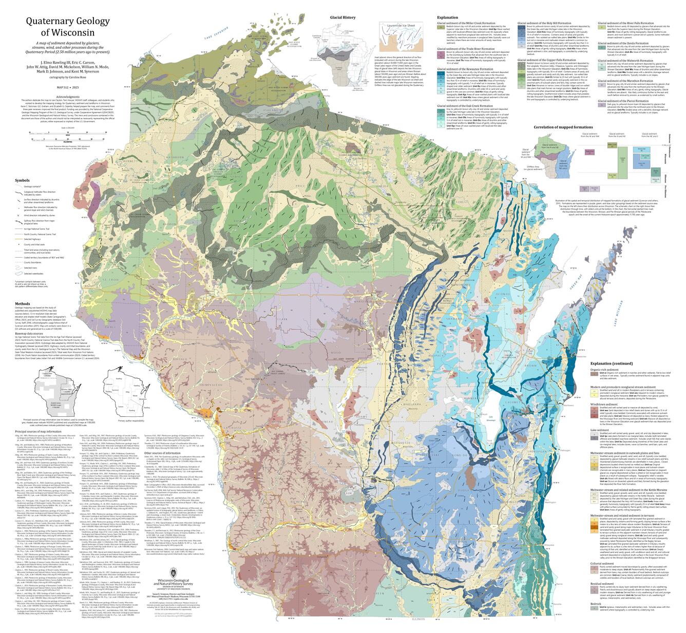
In March 2025 the Wisconsin Geological and Natural History Survey (WGNHS) published an updated Quaternary Geology Map of the state that has been fifty years in the making. This map not only brings to fruition the work of countless geologists but also represents a collaboration between WGNHS geologists and University of Wisconsin-Madison Extension partners who worked together to integrate numerous datasets into one product. The map highlights landforms that will be useful for outdoor enthusiasts, while identifying loose materials like sand and gravel that serve as vital resources for holding groundwater (used for drinking and agriculture) and construction materials.
For J. Elmo Rawling, WGNHS Quaternary geologist and project lead, this map is about more than providing updated sedimentary units and landforms as it has the promise to serve as a long-lasting tool to explain state geology.
“Hopefully this map will be hanging on classroom, visitor center, library, and agency walls across the state for decades and inspire an interest in the history of how glaciers, rivers, wind and other surface processes shaped Wisconsin’s landscapes.”
-J. Elmo Rawling
Great Lakes Geologic Mapping Coalition (GLGMC)
GLGMC Current Projects

Quaternary Geologic Mapping of the Glaciated Regions Project

FEDMAP

STATEMAP

EDMAP
The testimonials below demonstrate the impact of recent geologic mapping projects carried out by the GLGMC.
3D Viewer Enhances Stakeholders’ Understanding and Communication of Geology
The Illinois State Geological Survey (ISGS) has recently developed a public 3D interface for geological data. Stakeholders have requested tools to enhance the communication and illustration of geologic data, as well as support data queries and ordinances. Printed maps can sometimes limit the full understanding of sediment frameworks below the Earth’s surface. The 3D viewer created by ISGS allows the user to rapidly access subsurface information in a location of their choice in only a few clicks. In McHenry County, water levels in monitoring wells have been declining, and information from the GLGMC-derived 3D geological models were used to confirm the issue and begin discussions between local officials, developers and residents. Water resource managers successfully supported a county ordinance to protect a sensitive water supply by using the interface to effectively present critical information.
The image above shows a cross section created in the 3D viewer that was used to quickly assess the extent of an aquifer within a proposed area of development. One stakeholder remarked of the 3D viewer:
“I can’t do my job without it.”
The recently developed viewer has been used by engineers, consulting firms and even the Illinois Department of Transportation. It has become an essential tool for geotechnical data queries and conducting background research. Other users of the viewer have said that they
“much prefer the viewer over static maps”
and that even better than a picture, it is
“worth more than 1000 words!”
The monitoring wells in McHenry County that were used in this study are part of the U.S. Geological Survey's National Groundwater Monitoring Network. Using data from these wells in concert with models developed with the GLGMC derived 3D viewer is a shining example of the continued state and federal collaboration that embodies the integrated science effort that is the foundation of the Coalition.
Geologic Maps Help a Minnesota City Save Big!
The Minnesota Geological Survey (MGS) is carrying out a project called the County Geologic Atlas (CGA) program to inform statewide groundwater management, mineral resource, and civil engineering applications. The 1-kilometer cross sections seen here were published by the MGS as part of the CGA effort and help identify and model subsurface sand bodies that may serve as aquifers. The Minnesota Department of Natural Resources (DNR) has been partnering with the MGS on CGA reports since 1995. The geologic information provided in the MGS’s reports is utilized by the DNR to provide additional information on the groundwater conditions and pollution sensitivity of aquifers. Recently, the City of Motley in Cass County, Minnesota used subsurface information provided by MGS to identify a suitable location for a municipal water well. This depth-to-bedrock map is another of may products published by MGS as part of the Cass County CGA.
The data collected through an initial GLGMC investment of around \$50,000 helped the city save more than \$700,000 in well-drilling costs. Additionally, MGS cross sections from the Washington County Geologic Atlas have been used to model groundwater flow as part of remediation efforts associated with aquifer contamination.
Mapping an Ancient River Valley Across State Boundaries
Beginning in 2019, the Ohio Department of Natural Resources, Division of Geological Survey and Indiana Geological and Water Survey identified a cross-state need to characterize a regional section of the buried Teays-Mahomet (Teays) River Valley system through rotary sonic drilling. The Teays River, once part of a major pre-Quaternary drainage system, was altered and filled with unconsolidated deposits from multiple glacial events. Understanding the distribution of sediments in the ancient river valley will help present day residents by better constraining the water resource potential within the sand and gravel deposits that filled it. Collaboration between the two states to complete drilling and bedrock contour mapping within the Willshire 7.5-minute quadrangle encapsulated the cooperative nature of the GLGMC and showed how geologic mapping is necessary across state boundaries.
View Indiana's Map
View Ohio's Map
A Map for the Ages
In March 2025 the Wisconsin Geological and Natural History Survey (WGNHS) published an updated Quaternary Geology Map of the state that has been fifty years in the making. This map not only brings to fruition the work of countless geologists but also represents a collaboration between WGNHS geologists and University of Wisconsin-Madison Extension partners who worked together to integrate numerous datasets into one product. The map highlights landforms that will be useful for outdoor enthusiasts, while identifying loose materials like sand and gravel that serve as vital resources for holding groundwater (used for drinking and agriculture) and construction materials.
For J. Elmo Rawling, WGNHS Quaternary geologist and project lead, this map is about more than providing updated sedimentary units and landforms as it has the promise to serve as a long-lasting tool to explain state geology.
“Hopefully this map will be hanging on classroom, visitor center, library, and agency walls across the state for decades and inspire an interest in the history of how glaciers, rivers, wind and other surface processes shaped Wisconsin’s landscapes.”
-J. Elmo Rawling
Great Lakes Geologic Mapping Coalition (GLGMC)
GLGMC Current Projects
Quaternary Geologic Mapping of the Glaciated Regions Project
FEDMAP
STATEMAP