
Florence Bascom Geoscience Center
The primary mission of the Florence Bascom Geoscience Center (FBGC) is to provide detailed scientific data and assessments to support natural resource management, public safety, and national security. The FBGC specializes in:
Geologic mapping and hazards
Paleontology, stratigraphy, and environmental geology
Special geologic studies at the intersection of national security and mineral resources
USGS Scientists Help Address Conflict Mining

The USGS has collaborated with several international organizations working to track and monitor illegal mining and armed groups funded by natural resources around the world.
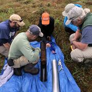
Mid-Atlantic Stream & Sediment Science

FBGC's ecologist Greg Noe's work is highlighted in this great article discussing legacy erosion and sedimentation in Mid-Atlantic watersheds.
Climate Change Impacts on Mangrove Forests

FBGC scientists Miriam Jones and Lynn Wingard were recently interviewed by NPR regarding climate change and mangrove forests.
Publications
Tidal forested wetlands can be incorporated into blue carbon conservation and restoration strategies Tidal forested wetlands can be incorporated into blue carbon conservation and restoration strategies
Preliminary bedrock geologic map of the Port Henry quadrangle, Essex County, New York, and Addison County, Vermont Preliminary bedrock geologic map of the Port Henry quadrangle, Essex County, New York, and Addison County, Vermont
Bascom Laser Diffraction Sedimentology Laboratory, Reston, Virginia Bascom Laser Diffraction Sedimentology Laboratory, Reston, Virginia
Science
Paleoscience for Partners: Reconstructing the Past to Prepare for the Future

Coastal Wetland Vulnerability to Climate Change and Sea-Level Rise: Understanding Ecological Thresholds and Ecosystem Transformations
