
Adaptive Management
Adaptive Management
Filter Total Items: 73

New Tools for Modern Land Management Decisions
In an era of rapid land use changes, it is imperative that land managers and policymakers have actionable and current information available for decision processes. In this work, we seek to meet these needs through new data products and decision support tools built on digital soil mapping, new vegetation cover maps, agency inventory and monitoring data sets, and cutting-edge analytical frameworks...

Supporting energy and mineral development through successful reclamation
Federal lands of the US contain important reserves of oil, gas and other resources important for Unleashing American Energy (SO 3418). After development of these resources is complete, successfully reclaiming disturbed lands is a necessary step towards restoring wildlife habitat, forage production, and maintaining natural resources for future use. To improve reclamation outcomes on these lands and...
Early detection of aquatic threats: eDNA research in the Colorado River ecosystem & Lake Powell
The USGS and partners are conducting environmental DNA (eDNA) research in the Colorado River downstream from Glen Canyon Dam and in Lake Powell to detect invasive fish species and other aquatic threats before they become established. eDNA is a cutting-edge technology that makes it possible to identify invasive species before they are visible, even in vast or hard-to-survey environments like rivers...

USGS Sagebrush Science: Supporting Public Safety and Economic Decision Making Across the West
The sagebrush biome is one of the largest ecosystems in North America. Encompassing nearly one-third of the continental U.S., it provides critical resources for millions of Americans and a home for hundreds of plants and animal species in the West. Natural resource management in sagebrush ecosystems can be complex, and science can support management decisions by providing knowledge and tools to...
By
Core Science Systems Mission Area, Ecosystems Mission Area, Biological Threats and Invasive Species Research Program, Climate Adaptation Science Centers, Cooperative Research Units, Land Management Research Program, Species Management Research Program, Earth Resources Observation and Science (EROS) Center , Forest and Rangeland Ecosystem Science Center, Fort Collins Science Center, Northern Rocky Mountain Science Center, Southwest Biological Science Center, Western Ecological Research Center (WERC), Wildland Fire Science

Biological Soil Crust ("Biocrust") Science
Biological soil crusts (biocrusts) are commonly found on the soil surface in arid and semi-arid ecosystems (collectively called drylands). Biocrusts can consist of mosses, cyanobacteria, lichens, algae, and microfungi, and they strongly interact with the soil. These organisms or consortium of disparate organisms, depending on the specific biocrust, are important to the functioning of ecosystems...

Monitoring the Rare Island Night Lizard on San Nicolas Island
The Island Night Lizard ( Xantusia riversiana) was removed from the Federal list of Threatened species in May 2014. This rare and unique species represents an ancient lineage whose members are now sparsely distributed across parts of the Southwest North America, south through Mexico to the New World Tropics. The information on population size and habitat helps to inform and guide conservation and...
Skill-building workshops for researchers on the coproduction of actionable science
Public lands management requires the use of science, but agency staff rarely have time to stay current with all the science on management-relevant topics, especially as articles are published at an ever-increasing rate. In this new series of learning modules, we aim to provide scientists with essential tools, skills, and strategies for coproducing actionable science products with and for federal...

Lake Powell Research
Lake Powell is a large arid reservoir that represents about 70% of the water storage capacity for the Upper Colorado River Basin. It is the second largest reservoir in the United States by capacity (second only to Lake Mead). Lake Powell is an oligotrophic reservoir, which means that nutrient concentrations and algal production are generally low. This often results in very clear-water conditions...

SBSC: Providing Unbiased Actionable Science & Information to Support Natural Resource Management Needs of the U.S. & Department of the Interior Priorities
The U.S. Geological Survey Southwest Biological Science Center (SBSC) is uniquely positioned in the Colorado River Basin to provide sound information, specialized expertise, and innovative tools to support the management and sustained use of natural resources on public and Tribal lands in the Southwest U.S.
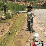
Vegetation monitoring: How one square meter can tell the story of 255 river miles along the Colorado River
The goal of SBSC's Grand Canyon Monitoring and Research Center’s (GCMRC) riparian vegetation monitoring program is to assess changes and trends in plant species composition and cover and relate those changes to river hydrology, climate, geomorphology, and the operations of Glen Canyon Dam.
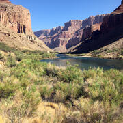
Riparian Vegetation in Grand Canyon: An Overview
Riparian plant communities, associated with rivers and streams, are ecologically and culturally important areas in the southwestern U.S. Despite covering less than 2% of the land area in the southwest, the resources provided by these communities make them valuable to wildlife, the public, scientists, and resource managers.

SBSC science supports invasive species management
Invasive species can harm ecosystems, increase wildfires, damage forests, and outcompete native species. The US Geological Survey's Southwest Biological Science Center conducts research that provides our federal and state partners, cooperators and land managers with the tools, data and strategies to enhance biosecurity management. Scroll through the information below to read about different SBSC...