
A targeted annual warning system (TAWS) for identifying aberrant declines in greater sage-grouse populations
Land and wildlife managers require accurate estimates of sensitive species’ trends to help guide conservation decisions that maintain biodiversity and promote healthy ecosystems. Multiple science centers with the U.S. Geological Survey (USGS), in conjunction with Colorado State University (CSU), developed a hierarchical population monitoring framework for managing greater sage-grouse (Centrocercus urophasianus; sage-grouse) populations and the sagebrush ecosystems on which they depend for survival and reproduction. Part of the hierarchical population monitoring strategy is the Targeted Annual Warning System (TAWS), which identifies where and when sage-grouse populations may benefit from targeted management interventions.

Additional Framework Components
Explore other components of the Greater Sage-Grouse Monitoring Framework or return to the framework's homepage using the links below.
Background
Resource managers and conservation practitioners have limited time and resources to devote towards monitoring and managing sage-grouse populations. Given the widespread declines in sage-grouse populations, managers need tools to identify populations likely to respond to specific management interventions.
Research Objective
This project aimed to develop a method of monitoring sage-grouse populations across their range within the United States. The framework was designed to help managers identify when and where populations were declining in response to local perturbations. By accounting for broad-scale factors that drive changes in population size, the framework can more effectively narrow its focus to threats within the purview of land and wildlife management agencies. Monitoring populations at multiple spatial scales was designed to capture perturbations ranging in size from point sources to large wildfires. Evaluating populations within a 2–4-year moving window enabled managers to respond to declines in a reasonable timeframe while avoiding false positives due to observational errors or stochastic processes.

Methods

Scientists from the U.S. Geological Survey (USGS) and Colorado State University (CSU) worked closely with state and federal agencies to develop a unified lek database, define hierarchically nested population clusters, and model population trends at three key spatial scales: (1) leks, (2) ‘neighborhoods’ of leks clustered together, and (3) clusters of neighborhoods, termed ‘climate’ clusters. The TAWS utilizes the collective output from these products to evaluate changes in population size and identify which populations could benefit most from monitoring and management.
A key feature of the framework is its ability to differentiate population changes, particularly declines, according to mechanisms that can or cannot be addressed by land and wildlife management agencies. Population clusters were developed with this goal and designed to capture a unique suite of factors at each spatial scale. Population change at the climate-cluster scale was driven by abiotic factors that often exhibit cyclic patterns. Changes in population size at the neighborhood and lek scales are influenced by the same abiotic factors and by local-level factors such as predator composition, land management practices, disease, and density-dependent mechanisms.
The TAWS framework compares annual estimates of rates of change in population size between management (i.e., neighborhood or lek) and climate scales, resulting in a metric that isolates the localized component of population performance. In doing so, it avoids false signals during periods of natural decline occurring within population cycles. This climate-adjusted metric was evaluated using a moving window spanning multiple years, and a categorical ranking was assigned based on the observed degree of decline. Signals could be used to identify when populations are declining in a way that warrants additional monitoring (e.g., “watch”) or management intervention (e.g., “warning”). Watches and warnings serve as the foundation of the TAWS framework and are intended to help guide management actions in a more targeted and localized manner.

Results and Implications
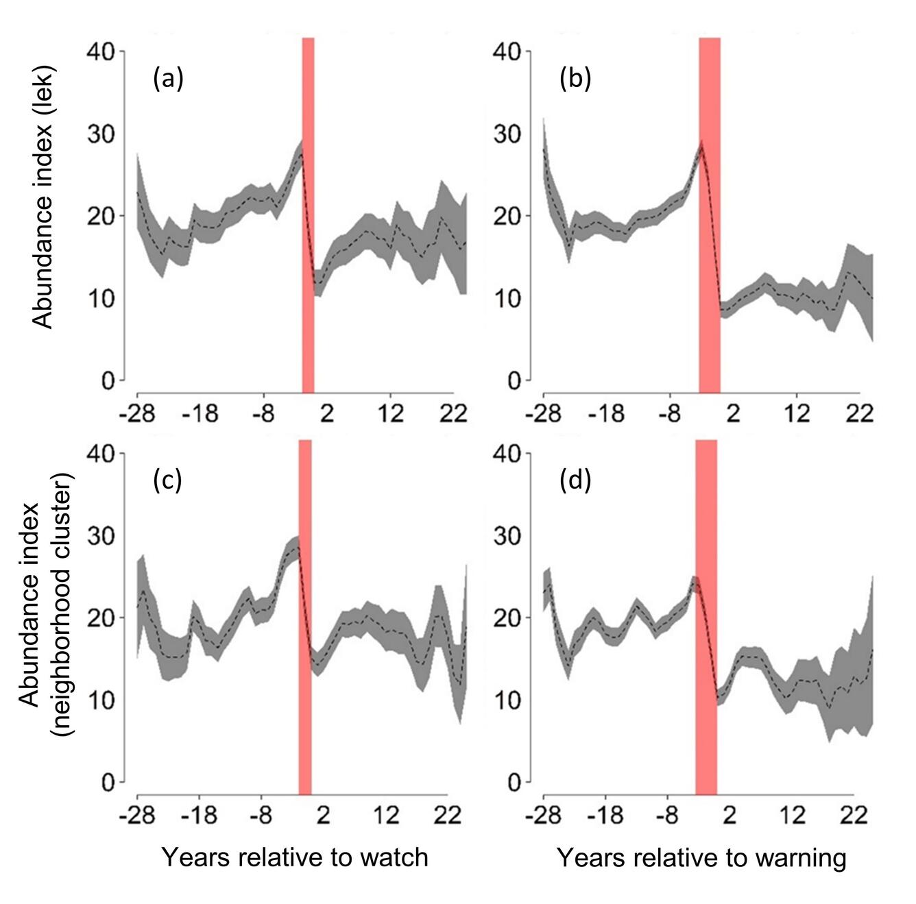
We applied the TAWS framework to over 4,400 leks distributed across the western United States, with estimates of population change spanning more than 30 years (1990–2024; Figure 3). Results revealed approximately 58–68% population declines immediately preceding watches or warnings (2–4-year period, Figure 4). Population trends unassociated with signals showed little to no evidence of decline. Furthermore, we found that an average annual rate of about 1.7% of leks, or 1.3% of neighborhood clusters (lek aggregations), would have required management intervention to reverse range-wide declines and stabilize the entire sage-grouse range.
Co-production
We continue working with all collaborators to improve sage-grouse management tools. Each year, we develop an updated version of a range-wide standardized lek count database to include new counts and historical corrections with improvements to data quality using rigorous quality control and quality methods. These data are incorporated into the TAWS framework and the SagePop application to produce results that are delivered in time for annual decision-making.
Data Restrictions
State wildlife agencies collect and manage lek databases. Because sage-grouse are a species of conservation concern and sensitive to activities during breeding, these data are available only after acquiring data-sharing agreements with individual states.
Funders
U.S. Geological Survey (Ecosystem Mission Area, Land Management Research Program and Species Management Research Program; Wyoming Landscape Conservation Initiative) and the Bureau of Land Management.
Partners
State Wildlife Agencies (California Department of Fish and Wildlife; Colorado Parks and Wildlife; Idaho Department of Fish and Game; Montana Fish, Wildlife & Parks; Nevada Department of Wildlife; North Dakota Game and Fish Department; Oregon Department of Fish and Wildlife; South Dakota Department of Game, Fish and Parks; Utah Division of Wildlife Resources; Wyoming Game and Fish Department; Washington Department of Fish and Wildlife), Colorado State University, BLM, US Fish and Wildlife Service, US Forest Service, researchers who provided field data to evaluate results.

Greater Sage-Grouse Population Monitoring Framework: Targeted Annual Warning System Information Sheet

Data Harmonization for Greater Sage-Grouse Populations

Greater Sage-Grouse Population Monitoring Framework: Frequently Asked Questions

Greater Sage-Grouse Population Monitoring Framework: Glossary of Terms

Greater Sage-Grouse Population Monitoring Framework

A user-friendly decision support tool for monitoring and managing greater sage-grouse populations

Estimating trends for greater sage-grouse populations within highly stochastic environments

Hierarchical Units of Greater Sage-Grouse Populations Informing Wildlife Management
Land and wildlife managers require accurate estimates of sensitive species’ trends to help guide conservation decisions that maintain biodiversity and promote healthy ecosystems. Multiple science centers with the U.S. Geological Survey (USGS), in conjunction with Colorado State University (CSU), developed a hierarchical population monitoring framework for managing greater sage-grouse (Centrocercus urophasianus; sage-grouse) populations and the sagebrush ecosystems on which they depend for survival and reproduction. Part of the hierarchical population monitoring strategy is the Targeted Annual Warning System (TAWS), which identifies where and when sage-grouse populations may benefit from targeted management interventions.
Additional Framework Components
Explore other components of the Greater Sage-Grouse Monitoring Framework or return to the framework's homepage using the links below.
Background
Resource managers and conservation practitioners have limited time and resources to devote towards monitoring and managing sage-grouse populations. Given the widespread declines in sage-grouse populations, managers need tools to identify populations likely to respond to specific management interventions.
Research Objective
This project aimed to develop a method of monitoring sage-grouse populations across their range within the United States. The framework was designed to help managers identify when and where populations were declining in response to local perturbations. By accounting for broad-scale factors that drive changes in population size, the framework can more effectively narrow its focus to threats within the purview of land and wildlife management agencies. Monitoring populations at multiple spatial scales was designed to capture perturbations ranging in size from point sources to large wildfires. Evaluating populations within a 2–4-year moving window enabled managers to respond to declines in a reasonable timeframe while avoiding false positives due to observational errors or stochastic processes.
Methods
Scientists from the U.S. Geological Survey (USGS) and Colorado State University (CSU) worked closely with state and federal agencies to develop a unified lek database, define hierarchically nested population clusters, and model population trends at three key spatial scales: (1) leks, (2) ‘neighborhoods’ of leks clustered together, and (3) clusters of neighborhoods, termed ‘climate’ clusters. The TAWS utilizes the collective output from these products to evaluate changes in population size and identify which populations could benefit most from monitoring and management.
A key feature of the framework is its ability to differentiate population changes, particularly declines, according to mechanisms that can or cannot be addressed by land and wildlife management agencies. Population clusters were developed with this goal and designed to capture a unique suite of factors at each spatial scale. Population change at the climate-cluster scale was driven by abiotic factors that often exhibit cyclic patterns. Changes in population size at the neighborhood and lek scales are influenced by the same abiotic factors and by local-level factors such as predator composition, land management practices, disease, and density-dependent mechanisms.
The TAWS framework compares annual estimates of rates of change in population size between management (i.e., neighborhood or lek) and climate scales, resulting in a metric that isolates the localized component of population performance. In doing so, it avoids false signals during periods of natural decline occurring within population cycles. This climate-adjusted metric was evaluated using a moving window spanning multiple years, and a categorical ranking was assigned based on the observed degree of decline. Signals could be used to identify when populations are declining in a way that warrants additional monitoring (e.g., “watch”) or management intervention (e.g., “warning”). Watches and warnings serve as the foundation of the TAWS framework and are intended to help guide management actions in a more targeted and localized manner.
Results and Implications
We applied the TAWS framework to over 4,400 leks distributed across the western United States, with estimates of population change spanning more than 30 years (1990–2024; Figure 3). Results revealed approximately 58–68% population declines immediately preceding watches or warnings (2–4-year period, Figure 4). Population trends unassociated with signals showed little to no evidence of decline. Furthermore, we found that an average annual rate of about 1.7% of leks, or 1.3% of neighborhood clusters (lek aggregations), would have required management intervention to reverse range-wide declines and stabilize the entire sage-grouse range.
Co-production
We continue working with all collaborators to improve sage-grouse management tools. Each year, we develop an updated version of a range-wide standardized lek count database to include new counts and historical corrections with improvements to data quality using rigorous quality control and quality methods. These data are incorporated into the TAWS framework and the SagePop application to produce results that are delivered in time for annual decision-making.
Data Restrictions
State wildlife agencies collect and manage lek databases. Because sage-grouse are a species of conservation concern and sensitive to activities during breeding, these data are available only after acquiring data-sharing agreements with individual states.
Funders
U.S. Geological Survey (Ecosystem Mission Area, Land Management Research Program and Species Management Research Program; Wyoming Landscape Conservation Initiative) and the Bureau of Land Management.
Partners
State Wildlife Agencies (California Department of Fish and Wildlife; Colorado Parks and Wildlife; Idaho Department of Fish and Game; Montana Fish, Wildlife & Parks; Nevada Department of Wildlife; North Dakota Game and Fish Department; Oregon Department of Fish and Wildlife; South Dakota Department of Game, Fish and Parks; Utah Division of Wildlife Resources; Wyoming Game and Fish Department; Washington Department of Fish and Wildlife), Colorado State University, BLM, US Fish and Wildlife Service, US Forest Service, researchers who provided field data to evaluate results.
Greater Sage-Grouse Population Monitoring Framework: Targeted Annual Warning System Information Sheet
Data Harmonization for Greater Sage-Grouse Populations
Greater Sage-Grouse Population Monitoring Framework: Frequently Asked Questions
Greater Sage-Grouse Population Monitoring Framework: Glossary of Terms
Greater Sage-Grouse Population Monitoring Framework
A user-friendly decision support tool for monitoring and managing greater sage-grouse populations
Estimating trends for greater sage-grouse populations within highly stochastic environments