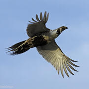
Michael O'Donnell is an ecologist at the Fort Collins Science Center. His work focuses primarily on sagebrush ecosystems.
Michael O’Donnell is an ecologist who has worked primarily in sagebrush ecosystems since 2008. He has focused on integrating data-intensive scientific discovery approaches that can facilitate a gained understanding of ecological processes, leading to better-informed prescriptions for decision-making actions. He has investigated a variety of biotic and abiotic studies across the sagebrush biome, including sage-grouse population frameworks/trends and habitat modeling, state-and-transition models, fire simulations, soil-climate budgets, as well as simulated land-use and climate change scenarios. He leverages information from a hybrid of scientific disciplines, such as ecology, geospatial sciences, remote sensing, statistics, and computer science to increase the understanding of complex multi-scale ecological relationships at community, regional, and global geographic extents.
Science and Products
Understanding How Vehicular Traffic Impacts Sage-Grouse Populations In Wyoming
Estimating road age and traffic volume for disturbance assessments in Wyoming
Road Ecology
Soil-climate for Managing Sagebrush Ecosystems
Climate Averages of Soil-climate for Sagebrush Ecosystems
Future Scenarios of Soil-climate for Sagebrush Ecosystems
Linking post-fire sagebrush restoration and sage-grouse habitat recovery
Changes in Sagebrush Ecosystem Connectivity
Data Harmonization for Greater Sage-Grouse Populations
Hierarchical Units of Greater Sage-Grouse Populations Informing Wildlife Management
Contributions to the development of the Western Association of Fish and Wildlife Agencies Sagebrush Conservation Strategy
Defining Multi-Scaled Functional Landscape Connectivity for the Sagebrush Biome to Support Management and Conservation Planning of Multiple Species
Wyoming Roads (Updated to 2015 Aerial Photography)
Sagebrush structural connectivity yearly and temporal trends based on RCMAP sagebrush products, biome-wide from 1985 to 2020
Genotypes and cluster definitions for a range-wide greater sage-grouse dataset collected 2005-2017 (ver 1.1, January 2023)
Greater sage-grouse genetic warning system, western United States (ver 1.1, January 2023)
Sagebrush (Artemisia spp.) scale of effect for Greater Sage-grouse (Centrocercus urophasianus) population trends in southwest Wyoming, USA 2003-2019
Trends and a Targeted Annual Warning System for Greater Sage-Grouse in the Western United States (ver. 2.0, May 2023)
U.S. range-wide spatial prediction layers of lek persistence probabilities for greater sage-grouse
Hierarchically nested and biologically relevant range-wide monitoring frameworks for greater sage-grouse, western United States
Soil-climate estimates in the western United States: climate averages (1981-2010)
Greater sage-grouse population structure and connectivity data to inform the development of hierarchical population units (western United States)
Gunnison sage-grouse habitat suitability of six satellite populations in southwestern Colorado: San Miguel, Crawford, Pinon Mesa, Dove Creek, Cerro Summit-Cimarron-Sims, and Poncha Pass
Sagebrush recovery analyzed with a dynamic reference approach in southwestern Wyoming, USA 1985-2018
Temporal patterns of structural sagebrush connectivity from 1985 to 2020
Range-wide population trend analysis for greater sage-grouse (Centrocercus urophasianus)—Updated 1960–2022
A targeted annual warning system developed for the conservation of a sagebrush indicator species
Range-wide population trend analysis for greater sage-grouse (Centrocercus urophasianus)—Updated 1960–2021
Spatial scale selection for informing species conservation in a changing landscape
A genetic warning system for a hierarchically structured wildlife monitoring framework
A regionally varying habitat model to inform management for greater sage-grouse persistence across their range
Defining biologically relevant and hierarchically nested population units to inform wildlife management
Spatial estimates of soil moisture for understanding ecological potential and risk: a case study for arid and semi-arid ecosystems
Defining fine-scaled population structure among continuously distributed populations
Balancing model generality and specificity in management-focused habitat selection models for Gunnison sage-grouse
Assessing vegetation recovery from energy development using a dynamic reference approach
grsg_lekdb: Compiling and standardizing greater sage-grouse lek databases, version 1.2.0
popcluster: hierarchical population monitoring frameworks, Version 2.0.0
Spatial scale selection for greater sage-grouse population trends, Version 1.0.0
spatial_nsm: Spatial estimates of soil-climate properties using a modified Newhall simulation model
grsg_lekdb: Compiling and standardizing greater sage-grouse lek databases, version 1.1.0
lcp_centrality: Defining least-cost paths and graph theory centrality measures
grsg_lekdb: Compiling and standardizing greater sage-grouse lek databases
popcluster: Developing Hierarchical Population Monitoring Frameworks for mobile species with high site fidelity
Geospatial Route Interface Tool (GRIT)
Science and Products
- Science
Filter Total Items: 18
Understanding How Vehicular Traffic Impacts Sage-Grouse Populations In Wyoming
In 2021, the Fort Collins Science Center initiated a research effort to 1) assess how traffic in Wyoming has impacted sage-grouse population growth rates, 2) identify the spatial scales at which these effects are most evident, and 3) identify what levels of traffic result in sage-grouse population declines.Estimating road age and traffic volume for disturbance assessments in Wyoming
In 2021, the Fort Collins Science Center initiated a research effort to estimate road age and annual traffic volumes across the majority of roads in Wyoming for assessing impacts to wildlife. Data on roads often focus on the ‘where’ (for example, spatial features) but neglect the ‘when’ (for example, road age) or ‘how much’ (for example, traffic volume). Knowing these characteristics is critical...Road Ecology
Roads and their associated infrastructure can cause substantial and pervasive effects on adjacent ecosystems but are necessary for the movement and redistribution of goods, people, wealth, and natural resources in modern societies. The Fort Collins Science Center has initiated research looking at how roads and traffic may be impacting sagebrush ecosystems and the wildlife inhabiting them. This...Soil-climate for Managing Sagebrush Ecosystems
Soil-climate describes the temperature and moisture conditions important for plant growth and function. Soil condition patterns determine which vegetation is most abundant, thus controlling which habitats, invasive species, fuels, and economic activities are present in a region. Here, we use a model to simulate the vertical movement of water in a soil profile to provide insights into landscape...Climate Averages of Soil-climate for Sagebrush Ecosystems
Soil conditions are a key part of functioning ecosystem and affect the distribution and abundance of plants, forage production, and habitat patterns. The distribution of soil conditions, as well as other environmental factors such as precipitation, temperature, geology, topography, and vegetation determine the patterns and dynamics of wildlife habitats and biodiversity across the landscape. We...Future Scenarios of Soil-climate for Sagebrush Ecosystems
Climate forecasts provide a unique tool to researchers and wildlife managers, allowing for a look into potential future climate conditions. Climate models provide multiple scenarios that assume different mitigation polices implemented by governments. By using these data in a statistical model to estimate soil-climate conditions, we can investigate the connection between future climate and...Linking post-fire sagebrush restoration and sage-grouse habitat recovery
Many revegetation projects are intended to benefit focal wildlife species. Yet, few scope the ability of revegetation efforts to yield habitat. To investigate the ability of alternative sagebrush (Artemisia species) planting strategies to recover habitat conditions for the greater sage-grouse (Centrocercus urophasianus), USGS and Colorado State University scientists developed a spatial vegetation...Changes in Sagebrush Ecosystem Connectivity
Disturbances, management, and changing environmental conditions have reshaped the sagebrush biome within the western United States. As a result, sagebrush cover and configuration have varied over space and time, influencing ecological processes and species' use of the landscape. Characterizing changes in sagebrush ecosystem connectivity over time will help us understand the effects of those...Data Harmonization for Greater Sage-Grouse Populations
Long-term wildlife monitoring is imperative for understanding population changes that can inform managers. However, working with population data collected by different organizations, across multiple jurisdictions, and over long time periods can be challenging due to different data management approaches and organizational priorities. Through this project, we aimed to collaborate with eleven state...Hierarchical Units of Greater Sage-Grouse Populations Informing Wildlife Management
Wildlife management boundaries frequently lack biological context, such as information on habitat resource availability and wildlife movements. To address this, we developed multiple levels of biologically relevant and hierarchically nested greater sage-grouse (Centrocercus urophasianus) population units that could facilitate management and conservation of populations and habitats.Contributions to the development of the Western Association of Fish and Wildlife Agencies Sagebrush Conservation Strategy
USGS scientists are contributing to the development of the Western Association of Fish and Wildlife Agencies Sagebrush Conservation Strategy, a strategy intended to provide guidance so that efforts to conserve the iconic greater sage-grouse can be expanded to the entire sagebrush biome to benefit the people and wildlife that depend on it.Defining Multi-Scaled Functional Landscape Connectivity for the Sagebrush Biome to Support Management and Conservation Planning of Multiple Species
USGS and Colorado State University scientists are modelling multispecies connectivity through intact and disturbed areas of the sagebrush landscape. - Data
Filter Total Items: 18
Wyoming Roads (Updated to 2015 Aerial Photography)
A dataset comprised of road centerlines in Wyoming, USA, digitized to 2015 aerial photography from the National Agriculture Imagery Program. This dataset is an update to a former U.S. Geological Survey Data Series (“Large scale Wyoming transportation data: a resource planning tool”: O'Donnell and others, 2014) digitized to 2009 aerial photography. The U.S. Geological Survey Fort Collins Science CeSagebrush structural connectivity yearly and temporal trends based on RCMAP sagebrush products, biome-wide from 1985 to 2020
This dataset includes modeled outputs for structural connectivity and trends in connectivity patterns in the sagebrush biome of the United States at 270-meter resolution. Connectivity was calculated using an omnidirectional circuit-based algorithm, with sources, targets, and conductance based on sagebrush fractional component from the RCMAP sagebrush products for 1985, 1990, 1995, 2000, 2005, 2010Genotypes and cluster definitions for a range-wide greater sage-grouse dataset collected 2005-2017 (ver 1.1, January 2023)
Monitoring change in genetic diversity in wildlife populations across multiple scales could facilitate prioritization of conservation efforts. We used microsatellite genotypes from 7,080 previously collected genetic samples from across the greater sage-grouse (Centrocercus urophasianus) range to develop a modelling framework for estimating genetic diversity within a recently developed hierarchicalGreater sage-grouse genetic warning system, western United States (ver 1.1, January 2023)
Genetic variation is a well-known indicator of population fitness yet is not typically included in monitoring programs for sensitive species. Additionally, most programs monitor populations at one scale, which can lead to potential mismatches with ecological processes critical to species’ conservation. Recently developed methods generating hierarchically nested population units (i.e., clusters ofSagebrush (Artemisia spp.) scale of effect for Greater Sage-grouse (Centrocercus urophasianus) population trends in southwest Wyoming, USA 2003-2019
The distance within which populations respond to features in a landscape (scale of effect) can indicate how disturbance and management may affect wildlife. Using annual counts of male Greater Sage-grouse (Centrocercus urophasianus) attending 584 leks in southwest Wyoming (2003-2019) and estimates of sagebrush cover from the Rangeland Condition Monitoring Assessment and Projection (RCMAP), we usedTrends and a Targeted Annual Warning System for Greater Sage-Grouse in the Western United States (ver. 2.0, May 2023)
Greater sage-grouse (Centrocercus urophasianus) are at the center of state and national land use policies largely because of their unique life-history traits as an ecological indicator for health of sagebrush ecosystems. These data represent an updated population trend analysis and Targeted Annual Warning System (TAWS) for state and federal land and wildlife managers to use best-available scienceU.S. range-wide spatial prediction layers of lek persistence probabilities for greater sage-grouse
This dataset contains two predictive lek (breeding site) persistence raster layers covering the U.S. greater sage-grouse distribution. In the United States, locations where males display and breed with females (i.e., leks) are often monitored annually by state wildlife agencies, providing valuable information on the persistence of birds in the surrounding areas. A U.S. range-wide lek database wasHierarchically nested and biologically relevant range-wide monitoring frameworks for greater sage-grouse, western United States
We produced 13 hierarchically nested cluster levels that reflect the results from developing a hierarchical monitoring framework for greater sage-grouse across the western United States. Polygons (clusters) within each cluster level group a population of sage-grouse leks (sage-grouse breeding grounds) and each level increasingly groups lek clusters from previous levels. We developed the hierarchicSoil-climate estimates in the western United States: climate averages (1981-2010)
We provide a collection of data reflecting estimates of soil-climate properties (moisture, temperature, and regimes) based on climate normals (1981-2010). Specifically, we provide estimates for soil moisture (monthly, seasonal, and annual), trends of spring and growing season soil moisture (Theil-Sen estimates), soil temperature and moisture regimes (STMRs; discrete classes defined by United StateGreater sage-grouse population structure and connectivity data to inform the development of hierarchical population units (western United States)
We present five hierarchical demarcations of greater sage-grouse population structure, representing the spatial structure of populations which can exist due to differences in dispersal abilities, landscape configurations, and mating behavior. These demarcations represent Thiessen polygons of graph constructs (least-cost path [LCP] minimum spanning trees [MST; LCP-MST]) representing greater sage-grGunnison sage-grouse habitat suitability of six satellite populations in southwestern Colorado: San Miguel, Crawford, Pinon Mesa, Dove Creek, Cerro Summit-Cimarron-Sims, and Poncha Pass
We developed habitat selection models for Gunnison sage-grouse (Centrocercus minimus), a threatened species under the U.S. Endangered Species Act. We followed a management-centric modeling approach that sought to balance the need to evaluate the consistency of key habitat conditions and improvement actions across multiple, distinct populations, while allowing context-specific environmental variablSagebrush recovery analyzed with a dynamic reference approach in southwestern Wyoming, USA 1985-2018
Identifying ecologically relevant reference sites is important for evaluating ecosystem recovery, but the relevance of references that are temporally static is unclear in the context of vast landscapes with disturbance and environmental contexts varying over space and time. This question is pertinent for landscapes dominated by sagebrush (Artemisia spp.) which face a suite of threats from disturba - Multimedia
- Publications
Filter Total Items: 45
Temporal patterns of structural sagebrush connectivity from 1985 to 2020
The sagebrush biome within the western United States has been reshaped by disturbances, management, and changing environmental conditions. As a result, sagebrush cover and configuration have varied over space and time, influencing processes and species that rely on contiguous, connected sagebrush. Previous studies have documented changes in sagebrush cover, but we know little about how the connectAuthorsErin K. Buchholtz, Michael O'Donnell, Julie A. Heinrichs, Cameron L. AldridgeRange-wide population trend analysis for greater sage-grouse (Centrocercus urophasianus)—Updated 1960–2022
Greater sage-grouse (Centrocercus urophasianus) are at the center of state and national land-use policies largely because of their unique life-history traits as an ecological indicator for health of sagebrush ecosystems. This updated population trend analysis provides state and federal land and wildlife managers with best-available science to help guide current management and conservation plans aiAuthorsPeter S. Coates, Brian G. Prochazka, Cameron L. Aldridge, Michael S. O'Donnell, David R. Edmunds, Adrian P. Monroe, Steven E. Hanser, Lief A. Wiechman, Michael P. ChenailleA targeted annual warning system developed for the conservation of a sagebrush indicator species
A fundamental goal of population ecologists is to identify drivers responsible for temporal variation in abundance. Understanding whether variation is associated with environmental stochasticity or anthropogenic disturbances, which are more amenable to management action, is crucial yet difficult to achieve. Here, we present a hierarchical monitoring framework that models rates of change in abundanAuthorsBrian G. Prochazka, Peter S. Coates, Michael O'Donnell, David R. Edmunds, Adrian P. Monroe, Mark A. Ricca, Gregory T. Wann, Steven E. Hanser, Lief A. Wiechman, Kevin E. Doherty, Michael P. Chenaille, Cameron L. AldridgeRange-wide population trend analysis for greater sage-grouse (Centrocercus urophasianus)—Updated 1960–2021
Greater sage-grouse (Centrocercus urophasianus) are at the center of state and national land use policies largely because of their unique life-history traits as an ecological indicator for health of sagebrush ecosystems. This updated population trend analysis provides state and federal land and wildlife managers with best-available science to help guide current management and conservation plans aiAuthorsPeter S. Coates, Brian G. Prochazka, Cameron L. Aldridge, Michael S. O'Donnell, David R. Edmunds, Adrian P. Monroe, Steven E. Hanser, Lief A. Wiechman, Michael P. ChenailleSpatial scale selection for informing species conservation in a changing landscape
Identifying the relevant spatial scale at which species respond to features in a landscape (scale of effect) is a pressing research need as managers work to reduce biodiversity loss amid a variety of environmental challenges. Until recently, researchers often evaluated a subset of potential scales of effect inferred from previous studies in other locations, often based on different biological respAuthorsAdrian P. Monroe, Julie A. Heinrichs, Ashley Lorraine Whipple, Michael O'Donnell, David R. Edmunds, Cameron L. AldridgeA genetic warning system for a hierarchically structured wildlife monitoring framework
Genetic variation is a well-known indicator of population fitness yet is not typically included in monitoring programs for sensitive species. Additionally, most programs monitor populations at one scale, which can lead to potential mismatches with ecological processes critical to species' conservation. Recently developed methods generating hierarchically nested population units (i.e., clusters ofAuthorsShawna J Zimmerman, Cameron L. Aldridge, Michael O'Donnell, David R. Edmunds, Peter S. Coates, Brian G. Prochazka, Jennifer A. Fike, Todd B. Cross, Bradley C. Fedy, Sara J. Oyler-McCanceA regionally varying habitat model to inform management for greater sage-grouse persistence across their range
Identifying habitat needs for species with large distributions is challenging because species-habitat associations may vary across scales and regions (spatial nonstationarity). Furthermore, management efforts often cross jurisdictional boundaries, complicating the development of cohesive conservation strategies among management entities. The greater sage-grouse (Centrocercus urophasianus) is a rapAuthorsGregory T. Wann, Nathan D. Van Schmidt, Jessica E. Shyvers, Bryan C. Tarbox, Megan M. McLachlan, Michael O'Donnell, Anthony J Titolo, Peter S. Coates, David R. Edmunds, Julie A. Heinrichs, Adrian P. Monroe, Cameron L. AldridgeDefining biologically relevant and hierarchically nested population units to inform wildlife management
Wildlife populations are increasingly affected by natural and anthropogenic changes that negatively alter biotic and abiotic processes at multiple spatiotemporal scales and therefore require increased wildlife management and conservation efforts. However, wildlife management boundaries frequently lack biological context and mechanisms to assess demographic data across the multiple spatiotemporal sAuthorsMichael O'Donnell, David R. Edmunds, Cameron L. Aldridge, Julie A. Heinrichs, Adrian P. Monroe, Peter S. Coates, Brian G. Prochazka, Steven E. Hanser, Lief A. WiechmanSpatial estimates of soil moisture for understanding ecological potential and risk: a case study for arid and semi-arid ecosystems
Soil temperature and moisture (soil-climate) affect plant growth and microbial metabolism, providing a mechanistic link between climate and growing conditions. However, spatially explicit soil-climate estimates that can inform management and research are lacking. We developed a framework to estimate spatiotemporal-varying soil moisture (monthly, annual, and seasonal) and temperature-moisture regimAuthorsMichael O'Donnell, Daniel ManierDefining fine-scaled population structure among continuously distributed populations
Understanding wildlife population structure and connectivity can help managers identify conservation strategies, as structure can facilitate the study of population changes and habitat connectivity can provide information on dispersal and biodiversity. To facilitate the use of wildlife monitoring data for improved adaptive management, we developed a novel approach to define hierarchical tiers (mulAuthorsMichael O'Donnell, David R. Edmunds, Cameron L. Aldridge, Julie A. Heinrichs, Adrian P. Monroe, Peter S. Coates, Brian G. Prochazka, Steven E. Hanser, Lief A. WiechmanBalancing model generality and specificity in management-focused habitat selection models for Gunnison sage-grouse
Identifying, protecting, and restoring habitats for declining wildlife populations is foundational to conservation and recovery planning for any species at risk of decline. Resource selection analysis is a key tool to assess habitat and prescribe management actions. Yet, it can be challenging to map suitable resource conditions across a wide range of ecological contexts and use the resulting modelAuthorsDorothy Saher, Michael O'Donnell, Cameron L. Aldridge, Julie A. HeinrichsAssessing vegetation recovery from energy development using a dynamic reference approach
Ecologically relevant references are useful for evaluating ecosystem recovery, but references that are temporally static may be less useful when environmental conditions and disturbances are spatially and temporally heterogeneous. This challenge is particularly acute for ecosystems dominated by sagebrush (Artemisia spp.), where communities may require decades to recover from disturbance. We demonsAuthorsAdrian P. Monroe, Travis W. Nauman, Cameron L. Aldridge, Michael O'Donnell, Michael C. Duniway, Brian S. Cade, Daniel Manier, Patrick J. Anderson - Software
grsg_lekdb: Compiling and standardizing greater sage-grouse lek databases, version 1.2.0
Greater sage-grouse (Centrocercus urophasianus; hereafter referred to as sage-grouse) are landscape-scale sagebrush obligate species and an important gamebird and iconic species of the West (Hanser & Knick, 2011; Rowland et al., 2006). They occupy the sagebrush biome in western North America, extending east of the Sierra Nevada/Cascade Mountain ranges to the western regions of the Great Plains ofpopcluster: hierarchical population monitoring frameworks, Version 2.0.0
We developed a method to construct hierarchically nested and biologically relevant groupings of similar habitats associated with field surveys while considering structure/connectedness (movements between habitats). This approach can support mobile species using high fidelity sites where monitoring during surveys occurs, such as birthing grounds, breeding grounds, or stopovers/seasonal habitats forSpatial scale selection for greater sage-grouse population trends, Version 1.0.0
The distance within which populations respond to features in a landscape (scale of effect) can indicate how disturbance and management may affect wildlife. Using annual counts of male greater sage-grouse (Centrocercus urophasianus) attending 584 leks in southwest Wyoming (2003-2019) and estimates of sagebrush (Artemisia spp.) cover from a remote sensing product (Rigge et al., 2021; Monroe et al.,spatial_nsm: Spatial estimates of soil-climate properties using a modified Newhall simulation model
We developed a software framework to estimate high-resolution spatiotemporal soil moisture (monthly, annual, and seasonal) and temperature-moisture regimes. Our approach builds on the Newhall simulation model, allowing for the substitution of data and parameters, such as climate, snowmelt, soil properties, alternative potential evapotranspiration equations, and air-soil temperature offsets. The Negrsg_lekdb: Compiling and standardizing greater sage-grouse lek databases, version 1.1.0
Greater sage-grouse (Centrocercus urophasianus) are landscape-scale sagebrush obligate species and an important gamebird and iconic species of the western United States. They occupy the sagebrush biome in western North America, extending east of the Sierra Nevada/Cascade Mountain ranges to the western regions of the Great Plains of the United States. Sage-grouse are one of the most closely monitorlcp_centrality: Defining least-cost paths and graph theory centrality measures
We present software that creates least-cost path spanning trees, a least-cost path minimum spanning tree, and graph theory centrality measures. The software was developed to support identification of population structures--specifically, greater sage-grouse (Centrocercus urophasianus), but also support other species or graph theory applications where least-cost paths are desired. We used habitat pagrsg_lekdb: Compiling and standardizing greater sage-grouse lek databases
Greater sage-grouse (Centrocercus urophasianus) are landscape-scale sagebrush obligate species and an important gamebird and iconic species of the western United States. They occupy the sagebrush biome in western North America, extending east of the Sierra Nevada/Cascade Mountain ranges to the western regions of the Great Plains of the United States. Sage-grouse are one of the most closely monitorpopcluster: Developing Hierarchical Population Monitoring Frameworks for mobile species with high site fidelity
The software "popcluster" constructs hierarchically nested groupings of similar habitats associated with field surveys while considering biological structure/connectedness (movements between habitats). This approach can support mobile species with high site fidelity where monitoring during surveys occurs on birthing grounds, breeding grounds, or stopovers/seasonal habitat for migratory species. EaGeospatial Route Interface Tool (GRIT)
The Geospatial Route Interface Tool (GRIT) is a Microsoft Windows desktop, graphical user interface application, written in an open source programming language (Python) that references ESRI Geographic Information System (GIS) python functions. The software streamlines and refines the process of analyzing transportation data and natural resources data, thereby improving the efficiency and standardi - News