The USGS EROS User Experience Webinar graphic.
Visit the webinar series webpage to learn more

Official websites use .gov
A .gov website belongs to an official government organization in the United States.
Secure .gov websites use HTTPS
A lock () or https:// means you’ve safely connected to the .gov website. Share sensitive information only on official, secure websites.
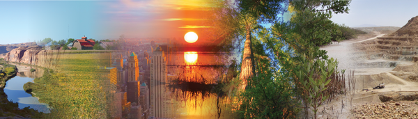
We maintain collections of images and videos that are available for download at no charge. Follow the links below to explore our multimedia.

In addition to their scientific value, many satellite images are simply intriguing to look at. Satellites capture an incredible variety of views of Earth. See the mesmerizing beauty of river deltas, mountains, and other sandy, salty, and icy landscapes.
A view of all 50 states from space. The images combine multiple Landsat scenes to showcase each state’s unique landscapes, from expansive forests and arid deserts to bustling cities and serene coastlines.
Watch Landsat Science Team members and researchers from around the world talk about the value of remotely sensed imagery to monitoring the health of the planet.
The USGS EROS User Experience Webinar graphic.
Visit the webinar series webpage to learn more
The USGS EROS User Experience Webinar graphic.
Visit the webinar series webpage to learn more
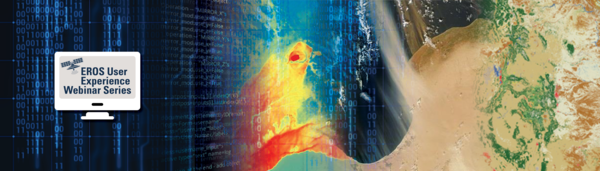
This image represents the topics discussed in the EROS User Experience Webinar Series.
Visit the webpage https://cms.usgs.gov/centers/eros/eros-user-experience-webinars
This image represents the topics discussed in the EROS User Experience Webinar Series.
Visit the webpage https://cms.usgs.gov/centers/eros/eros-user-experience-webinars
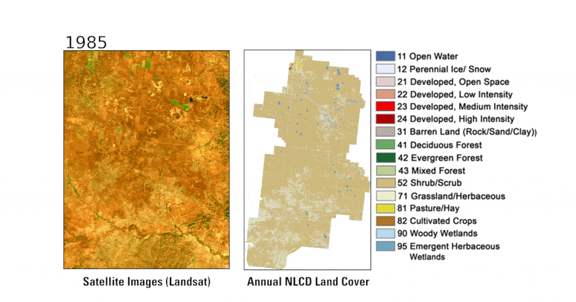
Landsat and Annual NLCD animations of the Powder River Basin area in eastern Wyoming from 1985 to 2024 show areas where mining has begun and has shifted over time.
Landsat and Annual NLCD animations of the Powder River Basin area in eastern Wyoming from 1985 to 2024 show areas where mining has begun and has shifted over time.
The Landsat Benefits Webpage Banner displays some ways of how Landsat data benefits the United States.
Visit the Landsat Benefits, State by State webpage to see how Landsat benefits your favorite State!
The Landsat Benefits Webpage Banner displays some ways of how Landsat data benefits the United States.
Visit the Landsat Benefits, State by State webpage to see how Landsat benefits your favorite State!
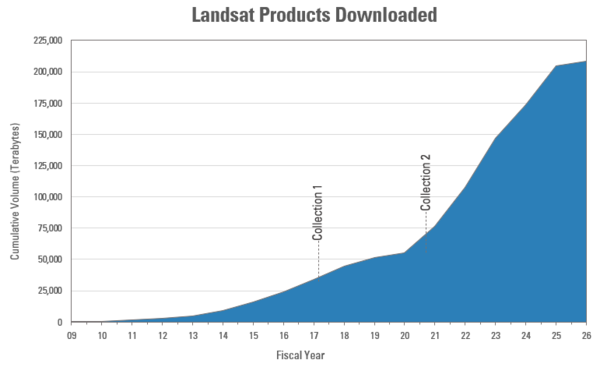
This graphic displays the cumulative volume of all operational Landsat products downloaded from the USGS EROS Landsat archive since December 2008 (FY2009). The release of Landsat Collection 2 products in 2020, which improved data quality and accessibility, helped drive downloads upward.
This graphic displays the cumulative volume of all operational Landsat products downloaded from the USGS EROS Landsat archive since December 2008 (FY2009). The release of Landsat Collection 2 products in 2020, which improved data quality and accessibility, helped drive downloads upward.
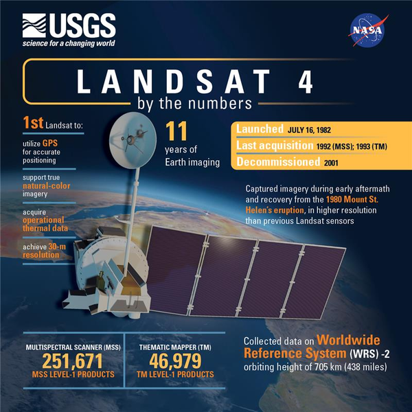
The Landsat 4 satellite was launched July 16, 1982, and ushered in many “firsts” that propelled the Landsat missions that followed.
The Landsat 4 satellite was launched July 16, 1982, and ushered in many “firsts” that propelled the Landsat missions that followed.

Rangeland managers need information on the current vegetation condition and how the landscape has changed through time. To address this need, scientists from the USGS and Bureau of Land Management (BLM) developed the Rangeland Condition Monitoring Assessment and Projection (RCMAP) project. These data classify western U.S.
Rangeland managers need information on the current vegetation condition and how the landscape has changed through time. To address this need, scientists from the USGS and Bureau of Land Management (BLM) developed the Rangeland Condition Monitoring Assessment and Projection (RCMAP) project. These data classify western U.S.
")
Greek firefighters battled a wildfire on the Greek island of Zakynthos in August 2025, one of many late summer fires in the Ionian Islands. Landsat 8 captured smoke, ash, burn scar, and thermal perimeter activity on August 12 in natural color and false color infrared.
Greek firefighters battled a wildfire on the Greek island of Zakynthos in August 2025, one of many late summer fires in the Ionian Islands. Landsat 8 captured smoke, ash, burn scar, and thermal perimeter activity on August 12 in natural color and false color infrared.
")
Multiple Landsat passes have captured the growth of the Dragon Bravo Fire in Kaibab National Forest near the North Rim of the Grand Canyon in Arizona.
On July 13, it destroyed the historic Grand Canyon Lodge. Dozens of other buildings have also been destroyed. As of August 15, the fire is 56% contained.

This video is a recording of a previous webinar entitled: “Simplifying Geospatial Data Workflows with NASA's AppEEARS”. This webinar was recorded on July 17, 2025.
This video is a recording of a previous webinar entitled: “Simplifying Geospatial Data Workflows with NASA's AppEEARS”. This webinar was recorded on July 17, 2025.
")
In May 2025, record rainfall in Australia's New South Wales created major flooding along the coast. In Taree, a mid-North Coast city, the Manning River reached a height of 6.4m on May 21st. The previous record of six meters was set back in 1929. The torrential rains have left almost 800 properties and counting uninhabitable in New South Wales.
In May 2025, record rainfall in Australia's New South Wales created major flooding along the coast. In Taree, a mid-North Coast city, the Manning River reached a height of 6.4m on May 21st. The previous record of six meters was set back in 1929. The torrential rains have left almost 800 properties and counting uninhabitable in New South Wales.

Calibration and validation (cal/val) are essential steps to ensure that remotely sensed data are reliable for scientific use. Radiometric cal/val involves converting digital image pixel values to meaningful units and assessing their accuracy.
Calibration and validation (cal/val) are essential steps to ensure that remotely sensed data are reliable for scientific use. Radiometric cal/val involves converting digital image pixel values to meaningful units and assessing their accuracy.
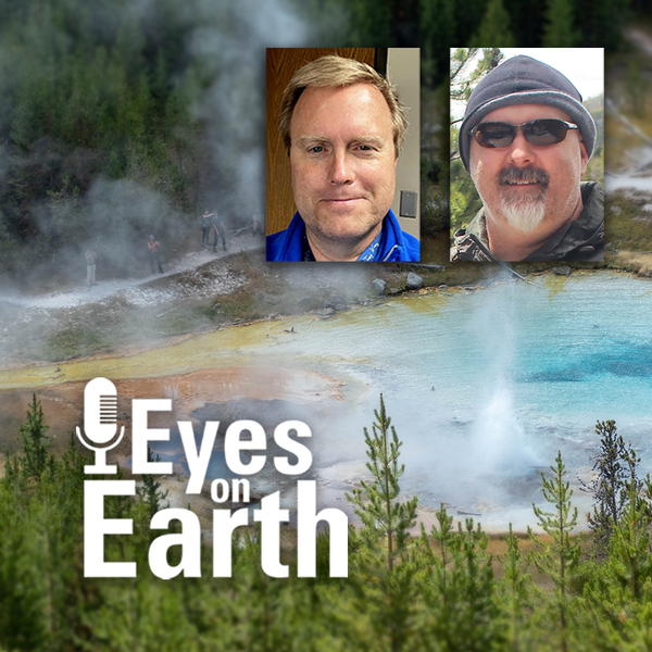
The Yellowstone National Park area has more than 10,000 thermal features. And while Old Faithful is a pretty predictable geyser, some thermal features can change quite a bit. New ones can even pop up! Remote sensing provides a tool for monitoring them—especially the thermal infrared sensors (TIRS) on Landsat 8 and Landsat 9 satellites.
The Yellowstone National Park area has more than 10,000 thermal features. And while Old Faithful is a pretty predictable geyser, some thermal features can change quite a bit. New ones can even pop up! Remote sensing provides a tool for monitoring them—especially the thermal infrared sensors (TIRS) on Landsat 8 and Landsat 9 satellites.
Exotic annual grasses, or EAGs, are invasive species. They outcompete native grasses. They are extremely flammable. And they are expanding into higher elevations. Targeted sheep grazing is one way to combat these invasive grasses, manage fire risk, and help restore native sagebrush in western states.
Exotic annual grasses, or EAGs, are invasive species. They outcompete native grasses. They are extremely flammable. And they are expanding into higher elevations. Targeted sheep grazing is one way to combat these invasive grasses, manage fire risk, and help restore native sagebrush in western states.
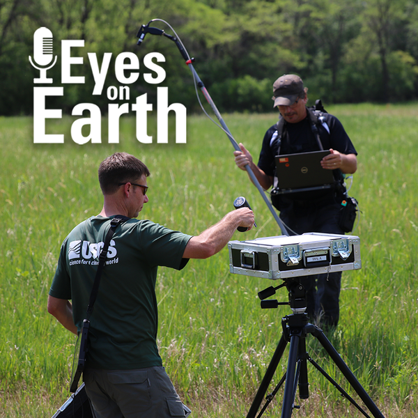
Landsat has been accurate and reliable for over 50 years because of the diligent calibration and validation work done by the team at EROS. One of the ways the team validates what they have so carefully calibrated is to take measurements on the ground while Landsat passes by overhead.
Landsat has been accurate and reliable for over 50 years because of the diligent calibration and validation work done by the team at EROS. One of the ways the team validates what they have so carefully calibrated is to take measurements on the ground while Landsat passes by overhead.
Landsat is the longest-running, continuously operating record of Earth observations, and it’s the gold standard reference point that other civil and commercial satellite programs trust.
Landsat is the longest-running, continuously operating record of Earth observations, and it’s the gold standard reference point that other civil and commercial satellite programs trust.
Declassified spy satellite imagery, distributed by the USGS EROS Center, is finding fascinating uses since being made available to the public starting in the 1990s.
Declassified spy satellite imagery, distributed by the USGS EROS Center, is finding fascinating uses since being made available to the public starting in the 1990s.
Eyes on Earth tackles artificial intelligence (AI) in a 2-part episode. AI is quickly becoming a necessary part of geospatial work at EROS, helping us efficiently do science to better manage our world. In Part 1, we talked about AI’s current and upcoming impact on our work at EROS and clarified some of the AI jargon.
Eyes on Earth tackles artificial intelligence (AI) in a 2-part episode. AI is quickly becoming a necessary part of geospatial work at EROS, helping us efficiently do science to better manage our world. In Part 1, we talked about AI’s current and upcoming impact on our work at EROS and clarified some of the AI jargon.