
This graph shows the number of Landsat Collection 2 Level-1 scene-based products that are available for download from the USGS Archive. Please note that data from earlier Landsat missions, even those that have ended, continues to be added to the archive through the Landsat Global Archive Consolidation (LGAC) program.
Multimedia
Our multimedia gallery represents a collection of high-quality images, videos, webcams, posters, presentations, and documents produced by Core Science Systems.
Images
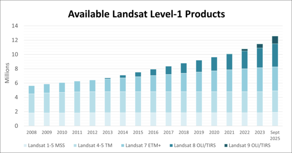
Available Landsat Level-1 Products
This graph shows the number of Landsat Collection 2 Level-1 scene-based products that are available for download from the USGS Archive. Please note that data from earlier Landsat missions, even those that have ended, continues to be added to the archive through the Landsat Global Archive Consolidation (LGAC) program.
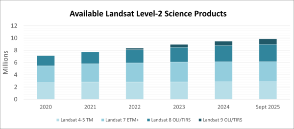
Available Landsat Level-2 Science Products
This graphic displays the number of Landsat Collection 2 Level-2 scene-based science products that are available for download from the USGS Archive. Level-2 science products were first introduced with the Collection 2 release in December, 2020. The Level-2 Science Product includes surface reflection and surface temperature data.
This graphic displays the number of Landsat Collection 2 Level-2 scene-based science products that are available for download from the USGS Archive. Level-2 science products were first introduced with the Collection 2 release in December, 2020. The Level-2 Science Product includes surface reflection and surface temperature data.
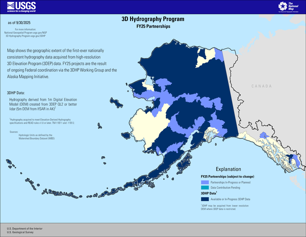
3D Hydrography Program FY25 Partnerships in Alaska
3D Hydrography Program FY25 Partnerships in AlaskaThis map of Alaska shows geographic extent of the first-ever nationally consistent hydrography data acquired from high-resolution 3D Elevation Program (3DEP) data. FY25 projects are the result of ongoing Federal coordination via the 3DHP Working Group and the Alaska Mapping Initiative.
Explanation

OnDemand - 100K - BND - State - Label
A primary governmental division of the United States or a United States jurisdiction that is neither a part of one of the several States nor a federal district (for example, the United States Virgin Islands).
A primary governmental division of the United States or a United States jurisdiction that is neither a part of one of the several States nor a federal district (for example, the United States Virgin Islands).
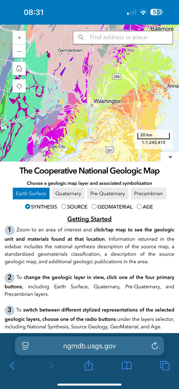
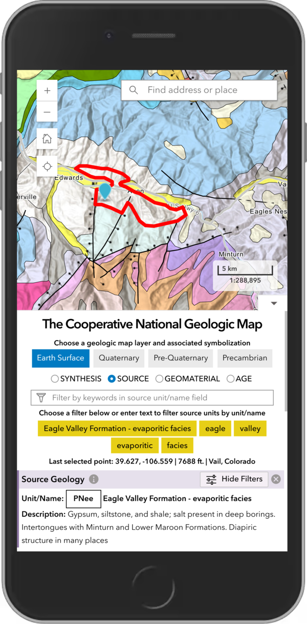
The USGS Cooperative National Geologic Map on a smartphone
The USGS Cooperative National Geologic Map on a smartphoneThe new USGS Cooperative National Geologic Map web tool was designed to be mobile friendly, allowing users to explore geologic data easily from their smartphones or tablets. USGS image.
The USGS Cooperative National Geologic Map on smartphone
The USGS Cooperative National Geologic Map on smartphoneThe new USGS Cooperative National Geologic Map web tool was designed to also be mobile friendly, allowing users to explore geologic data from smartphones and tablets, in addition to larger devices. USGS image.
Videos

Visualizing Rangeland Change with RCMAP Data
Rangeland managers need information on the current vegetation condition and how the landscape has changed through time. To address this need, scientists from the USGS and Bureau of Land Management (BLM) developed the Rangeland Condition Monitoring Assessment and Projection (RCMAP) project. These data classify western U.S.
Rangeland managers need information on the current vegetation condition and how the landscape has changed through time. To address this need, scientists from the USGS and Bureau of Land Management (BLM) developed the Rangeland Condition Monitoring Assessment and Projection (RCMAP) project. These data classify western U.S.

B-Roll: Field and drone remote sensing operations near Moab, Utah – May 2025
B-Roll: Field and drone remote sensing operations near Moab, Utah – May 2025In May 2025, the U.S. Geological Survey (USGS) National Uncrewed Systems Office (NUSO) collected uncrewed aircraft system (UAS, also known as drone) data to support a collaborative field campaign led by Sasha Reed of the Southwest Biological Science Center (SBSC) and Miguel Villarreal of the Western Geographic Science Center (WGSC) near Moab, Utah.
")
Greek Island Wildfire (Image of the Week)
Greek firefighters battled a wildfire on the Greek island of Zakynthos in August 2025, one of many late summer fires in the Ionian Islands. Landsat 8 captured smoke, ash, burn scar, and thermal perimeter activity on August 12 in natural color and false color infrared.
Greek firefighters battled a wildfire on the Greek island of Zakynthos in August 2025, one of many late summer fires in the Ionian Islands. Landsat 8 captured smoke, ash, burn scar, and thermal perimeter activity on August 12 in natural color and false color infrared.
")
Grand Canyon Megafire (Image of the Week)
Multiple Landsat passes have captured the growth of the Dragon Bravo Fire in Kaibab National Forest near the North Rim of the Grand Canyon in Arizona.
On July 13, it destroyed the historic Grand Canyon Lodge. Dozens of other buildings have also been destroyed. As of August 15, the fire is 56% contained.

FY26 3DNTM Data Collaboration Announcement Informational Webinar
FY26 3DNTM Data Collaboration Announcement Informational WebinarThe informational webinar for the Federal fiscal year (FY) 2026 3D National Topography Model (3DNTM) Data Collaboration Announcement was held on Wednesday, August 6, 2025 at 1pm ET. The USGS provided an overview of the application process followed by a Q&A session.
More Information:

July 22, 2025 USGS Hydrography Community Call
Steve Aichele, the National Geospatial Program Hydrography Management and Planning Lead, announced publication of the Holston River, TN hydrologic unit 10 (0601010403) in the 3D Hydrography Program web map services and provided update on HydroAdd planned release of the Beta version (August 2025) and version 1.0 (September 2025).
Steve Aichele, the National Geospatial Program Hydrography Management and Planning Lead, announced publication of the Holston River, TN hydrologic unit 10 (0601010403) in the 3D Hydrography Program web map services and provided update on HydroAdd planned release of the Beta version (August 2025) and version 1.0 (September 2025).
Audio
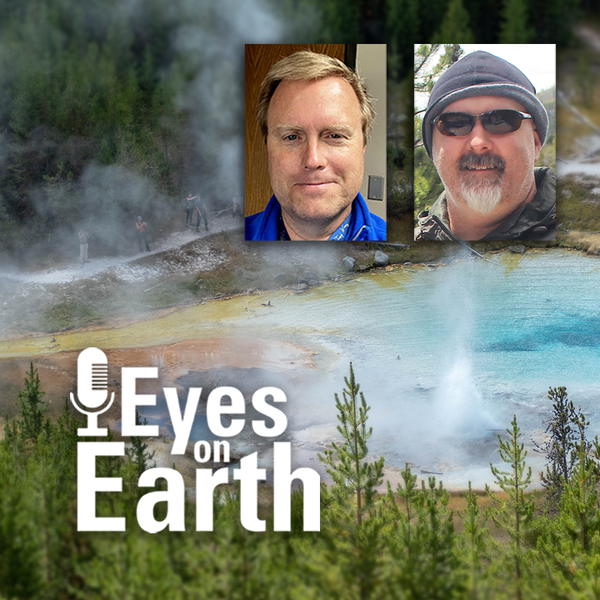
Eyes on Earth Episode 137 – Landsat Takes Yellowstone’s Temperature
Eyes on Earth Episode 137 – Landsat Takes Yellowstone’s TemperatureThe Yellowstone National Park area has more than 10,000 thermal features. And while Old Faithful is a pretty predictable geyser, some thermal features can change quite a bit. New ones can even pop up! Remote sensing provides a tool for monitoring them—especially the thermal infrared sensors (TIRS) on Landsat 8 and Landsat 9 satellites.

Eyes on Earth Episode 135 – Exotic Annual Grasses and Sheep Grazing
Eyes on Earth Episode 135 – Exotic Annual Grasses and Sheep GrazingExotic annual grasses, or EAGs, are invasive species. They outcompete native grasses. They are extremely flammable. And they are expanding into higher elevations. Targeted sheep grazing is one way to combat these invasive grasses, manage fire risk, and help restore native sagebrush in western states.
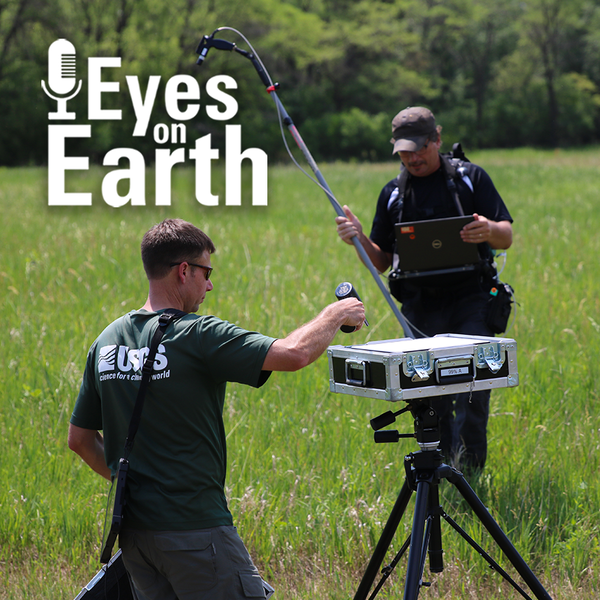
Eyes on Earth Episode 136 – The EROS Test Site
Landsat has been accurate and reliable for over 50 years because of the diligent calibration and validation work done by the team at EROS. One of the ways the team validates what they have so carefully calibrated is to take measurements on the ground while Landsat passes by overhead.
Landsat has been accurate and reliable for over 50 years because of the diligent calibration and validation work done by the team at EROS. One of the ways the team validates what they have so carefully calibrated is to take measurements on the ground while Landsat passes by overhead.

Eyes on Earth Episode 134 – Data Accuracy: The Calibration and Validation of Landsat
Eyes on Earth Episode 134 – Data Accuracy: The Calibration and Validation of LandsatLandsat is the longest-running, continuously operating record of Earth observations, and it’s the gold standard reference point that other civil and commercial satellite programs trust.

Eyes on Earth Episode 133 – Vietnam War Bomb Craters
Eyes on Earth Episode 133 – Vietnam War Bomb CratersDeclassified spy satellite imagery, distributed by the USGS EROS Center, is finding fascinating uses since being made available to the public starting in the 1990s.
Eyes on Earth Episode 133 – Vietnam War Bomb Craters
Eyes on Earth Episode 133 – Vietnam War Bomb CratersDeclassified spy satellite imagery, distributed by the USGS EROS Center, is finding fascinating uses since being made available to the public starting in the 1990s.

Eyes on Earth Episode 132 - Moving Forward with AI at EROS
Eyes on Earth Episode 132 - Moving Forward with AI at EROSEyes on Earth tackles artificial intelligence (AI) in a 2-part episode. AI is quickly becoming a necessary part of geospatial work at EROS, helping us efficiently do science to better manage our world. In Part 1, we talked about AI’s current and upcoming impact on our work at EROS and clarified some of the AI jargon.