
GLORIA sites within Glacier National Park
Images
Explore images taken during Ecosystems' Land Change Science Program fieldwork and research.
Filter Total Items: 196

GLORIA sites within Glacier National Park
GLORIA sites within Glacier National Park

Global distribution of GLORIA sites
Global distribution of GLORIA sites.

Collecting Field Data at Gulkana Glacier
USGS scientists collect field data at Gulkana Glacier in the eastern Alaska Range. The checkerboard sampling pattern in the foreground indicates where snow pit density measurements were collected.
USGS scientists collect field data at Gulkana Glacier in the eastern Alaska Range. The checkerboard sampling pattern in the foreground indicates where snow pit density measurements were collected.

Gulkana Glacier weather station
A scientist checks data collection on multiple sensors at the Gulkana Glacier weather station where snow blankets the glacier surface.
A scientist checks data collection on multiple sensors at the Gulkana Glacier weather station where snow blankets the glacier surface.

Steep terrain of the Bridger Mountains, Montana
Image showing the overview of a study site in the steep terrain of the Bridger Mountains of southwest Montanataken by an Uncrewed Aircraft System (UAS) while collecting data. The site’s complex terrain and topography are being studied to gain insights into snow depth and distribution in previously inaccessible areas.
Image showing the overview of a study site in the steep terrain of the Bridger Mountains of southwest Montanataken by an Uncrewed Aircraft System (UAS) while collecting data. The site’s complex terrain and topography are being studied to gain insights into snow depth and distribution in previously inaccessible areas.
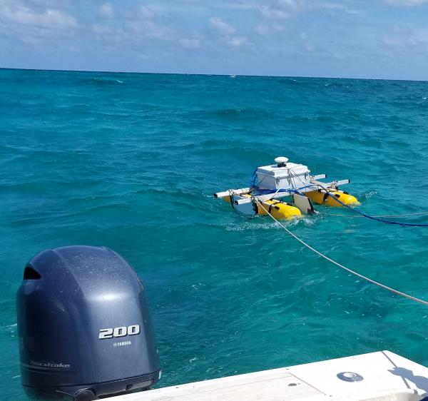
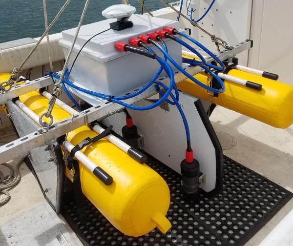
SQUID-5 - Structure-from-Motion Quantitative Underwater Imaging Device
SQUID-5 - Structure-from-Motion Quantitative Underwater Imaging DeviceThe SQUID-5, or a Structure-from-Motion (SfM) Quantitative Underwater Imaging Device with 5 cameras is a towed surface vehicle with an onboard Global Navigation Satellite System (GNSS) and 5 downward-looking cameras with overlapping views of the seafloor.

Retrieving a sediment trap in the Gulf of Mexico
A large winch on the stern of R/V Pelican is used to retrieve two sediment traps from the bottom of the Gulf of Mexico.
A large winch on the stern of R/V Pelican is used to retrieve two sediment traps from the bottom of the Gulf of Mexico.

Caitlin Reynolds collects samples from sediment trap
Caitlin Reynolds collects samples from sediment trapHere, Caitlin Reynolds sits on the R/V Pelican next to a sediment trap that collects samples in the Gulf of America.
Caitlin Reynolds collects samples from sediment trap
Caitlin Reynolds collects samples from sediment trapHere, Caitlin Reynolds sits on the R/V Pelican next to a sediment trap that collects samples in the Gulf of America.

CTD rosette being deployed
A CTD-rosette is a commonly used instrument that measures conductivity (that can inform scientists about salinity), temperature, and depth (CTD). As the instrument is lowered into the water--sometimes down to great depths--the cylinders around will open at various depths to collect water samples at discrete locations throughout the water column.
A CTD-rosette is a commonly used instrument that measures conductivity (that can inform scientists about salinity), temperature, and depth (CTD). As the instrument is lowered into the water--sometimes down to great depths--the cylinders around will open at various depths to collect water samples at discrete locations throughout the water column.

Caitlin Reynolds with a sediment trap in the Gulf of Mexico
Caitlin Reynolds with a sediment trap in the Gulf of MexicoCaitlin Reynolds of the USGS St. Petersburg Coastal and Marine Science Center secures a sediment trap, retrieved from the bottom of the Gulf of Mexico on board the R/V Pelican.
Caitlin Reynolds with a sediment trap in the Gulf of Mexico
Caitlin Reynolds with a sediment trap in the Gulf of MexicoCaitlin Reynolds of the USGS St. Petersburg Coastal and Marine Science Center secures a sediment trap, retrieved from the bottom of the Gulf of Mexico on board the R/V Pelican.

Sunset on a research vessel in the Gulf of Mexico
A beautiful sun set over the Gulf of Mexico from the stern of the R/V Pelican.
A beautiful sun set over the Gulf of Mexico from the stern of the R/V Pelican.

Coral-reef core from the USGS core archive
This core sample was taken from an elkhorn coral reef offshore of the Fort Lauderdale region of Florida. Samples from coral skeletons are taken from numerous locations in the core for radiocarbon dating, which tells scientists the age of each coral and of sections within the reef. The corals in this core lived from 7,100 to 6,200 years ago.
This core sample was taken from an elkhorn coral reef offshore of the Fort Lauderdale region of Florida. Samples from coral skeletons are taken from numerous locations in the core for radiocarbon dating, which tells scientists the age of each coral and of sections within the reef. The corals in this core lived from 7,100 to 6,200 years ago.

Various clues determine reliable coral samples
This piece of a core sample taken from offshore of the Fort Lauderdale region of Florida is from an elkhorn coral that lived 6,200 years ago. Coral type, orientation of corallites, and evidence of other fauna and characteristics within the core sample are used to determine how reliable the coral sample is to use for past sea-level reconstruction.
This piece of a core sample taken from offshore of the Fort Lauderdale region of Florida is from an elkhorn coral that lived 6,200 years ago. Coral type, orientation of corallites, and evidence of other fauna and characteristics within the core sample are used to determine how reliable the coral sample is to use for past sea-level reconstruction.
SQUID-5 - Structure-from-Motion Quantitative Underwater Imaging Device
SQUID-5 - Structure-from-Motion Quantitative Underwater Imaging DeviceThe SQUID-5, or a Structure-from-Motion (SfM) Quantitative Underwater Imaging Device with 5 cameras is a towed surface vehicle with an onboard Global Navigation Satellite System (GNSS) and 5 downward-looking cameras with overlapping views of the seafloor.

Uncrewed aircraft system landing zone in Bridger Mountains
Uncrewed aircraft system landing zone in Bridger MountainsThe Uncrewed Aircraft System (UAS) landing zone with the study site in the background. Bridger Mountains, MT.
Uncrewed aircraft system landing zone in Bridger Mountains
Uncrewed aircraft system landing zone in Bridger MountainsThe Uncrewed Aircraft System (UAS) landing zone with the study site in the background. Bridger Mountains, MT.
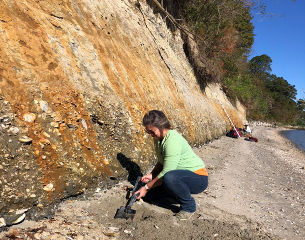
Marci Robinson Collecting Samples
Marci Robinson collects sediment and fossilized shell samples from the Yorktown Formation in Virginia.
Marci Robinson collects sediment and fossilized shell samples from the Yorktown Formation in Virginia.

Repeat photography helps document glacier change
USGS scientists at the Northern Rocky Mountain Science Center use repeat photography to document glacier change and as a communication tool.
USGS scientists at the Northern Rocky Mountain Science Center use repeat photography to document glacier change and as a communication tool.

Marine Sediment Cores from Southern Maryland
A USGS marine sediment core from southern Maryland. The changes in deposition at the PETM are clearly apparent in the core as it changes abruptly from dark sand (lower right side of box is oldest) to lighter clay (upper left side of box is youngest), indicating sudden environmental changes associated with a large pulse of atmospheric carbon.
A USGS marine sediment core from southern Maryland. The changes in deposition at the PETM are clearly apparent in the core as it changes abruptly from dark sand (lower right side of box is oldest) to lighter clay (upper left side of box is youngest), indicating sudden environmental changes associated with a large pulse of atmospheric carbon.

Scientists collect alpine plant species and distribution data in GNP
Scientists collect alpine plant species and distribution data in GNPScientists collect alpine plant species and distribution data to complete a GLORIA site inventory on the summit of Seward Mountain, Glacier National Park, Montana.

Scientists use grids to collect alpine plant data according to GLORIA
Scientists use grids to collect alpine plant data according to GLORIAScientists use grids to collect alpine plant data according to GLORIA protocols on the summit of Bison Mountain in Glacier National Park, Montana.
Scientists use grids to collect alpine plant data according to GLORIA
Scientists use grids to collect alpine plant data according to GLORIAScientists use grids to collect alpine plant data according to GLORIA protocols on the summit of Bison Mountain in Glacier National Park, Montana.

Researchers evaluate vegetation during a GLORIA alpine plant survey
Researchers evaluate vegetation during a GLORIA alpine plant surveyResearchers evaluate vegetation during a GLORIA alpine plant survey near the summit of Seward Mountain in Glacier National Park, Montana.
Researchers evaluate vegetation during a GLORIA alpine plant survey
Researchers evaluate vegetation during a GLORIA alpine plant surveyResearchers evaluate vegetation during a GLORIA alpine plant survey near the summit of Seward Mountain in Glacier National Park, Montana.