
Global Seabed Mineral Resources
Providing stakeholders with best available science regarding potential resources and environmental impacts associated with accessing those resources
Providing stakeholders with best available science regarding potential resources and environmental impacts associated with accessing those resources
Major Update to Satellite-Based Datasets Used to Assess Salt Marsh Vulnerability Nationwide
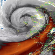
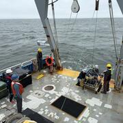
Seafloor Seismographs Rapidly Deployed Following Major Earthquake Offshore Northern California
Coral reef restoration
Cost-benefit study confirms coral reef restoration could be a cost-effective way to save lives and money
Cost-benefit study confirms coral reef restoration could be a cost-effective way to save lives and money
Ocean
USGS science improves our understanding of ocean processes, marine resources and submarine geohazards.
USGS science improves our understanding of ocean processes, marine resources and submarine geohazards.
Coasts
USGS provides critical science that informs risk reduction, protecting people, businesses, infrastructure, and resources along our coastlines, where 40% of our population lives.
USGS provides critical science that informs risk reduction, protecting people, businesses, infrastructure, and resources along our coastlines, where 40% of our population lives.
Meet the Coastal Science Navigator
Learn more about this new product to help you find useful USGS coastal data and tools
Learn more about this new product to help you find useful USGS coastal data and tools
Coastal and Marine Hazards and Resources Program
Scientists and staff study coastal and ocean processes, from shorelines to the deep sea, to identify hazards and provide critical information on our nation's resources. This work supports preparedness, emergency response, and the protection of people and resources in coastal and ocean environments.
Sound Waves Newsletter
Sound Waves Newsletter

Coastal and marine news from across the U.S. Geological Survey

News
Morphodynamics of dune-based coastal flood mitigation under sea-level rise
Morphodynamics of dune-based coastal flood mitigation under sea-level rise
A mid-ocean ridge revealed by 3D magnetic modeling: New geologic map of Escanaba Trough
A mid-ocean ridge revealed by 3D magnetic modeling: New geologic map of Escanaba Trough
Waves, not just runoff, drive sediment buildup on American Samoa coral reefs
Waves, not just runoff, drive sediment buildup on American Samoa coral reefs
Publications
Loss and transformation of coastal wetlands due to global change in the conterminous United States: Past, present, and future Loss and transformation of coastal wetlands due to global change in the conterminous United States: Past, present, and future
Coastal wetlands are being transformed by global change, impacting the ecological and societal benefits provided by these ecosystems. Synthesizing knowledge of historical and expected future transformations in coastal wetlands can help inform forward-looking planning and stewardship efforts. Here, we review anticipated future ecological transformations in coastal wetlands of the...
By
Ecosystems Mission Area, Water Resources Mission Area, Coastal and Marine Hazards and Resources Program, California Water Science Center, Eastern Ecological Science Center, Great Lakes Science Center, Pacific Coastal and Marine Science Center, St. Petersburg Coastal and Marine Science Center, Western Ecological Research Center (WERC), Wetland and Aquatic Research Center , Woods Hole Coastal and Marine Science Center
Improving offshore 3D splay fault geometries and slip histories using seismic data reprocessing and structural modeling Improving offshore 3D splay fault geometries and slip histories using seismic data reprocessing and structural modeling
The goal of this project as written in the CRESCENT seed grant proposal was as follows: 1) reprocess selected profiles along strike from 45° to 48°N from the CASIE21 crustal-scale seismic data to obtain higher-resolution and higher-quality imaging of the uppermost 1-2 km of the accretionary wedge; 2) convert high-resolution USGS sparker seismic data from the time to depth domain to...
Storm surge barriers reduce seaward sediment supply to lagoonal estuaries Storm surge barriers reduce seaward sediment supply to lagoonal estuaries
Numerical simulations with realistic forcing of fixed infrastructure for a proposed storm surge barrier for a lagoonal estuary, Jamaica Bay (New York, USA), are analyzed during typical forcing conditions to assess alterations to flow and sediment transport with the barrier open. Lagoonal estuaries are shallow and have modest watershed freshwater and sediment inputs, so sediment delivery...
Science

COAWST: A Coupled-Ocean-Atmosphere-Wave-Sediment Transport Modeling System
Understanding the processes responsible for coastal change is important for managing both our natural and economic coastal resources. Storms are one of the primary driving forces causing coastal change from a coupling of wave- and wind-driven flows. To better understand storm impacts and their effects on our coastlines, there is an international need to better predict storm paths and intensities...
Typhoon Merbok Disaster Recovery Project: Accomplishments
The Typhoon Merbok Disaster Emergency Recovery Efforts project addresses critical data and capacity gaps in coastal Alaska by generating high resolution environmental datasets, hazard analyses, and monitoring tools needed to quantify erosion, flooding, and permafrost-related risks at the community scale.
Coastal and Marine Science in Long Island Sound
Long Island Sound is a highly productive estuary and vital natural resource bordering New York and Connecticut. It’s essential for its massive economic impact, generating billions annually by supporting recreation, fisheries, and transportation, as well as its biodiversity, serving as a critical habitat for thousands of marine species. USGS research in Long Island Sound helps protect these...