
Paleoscience for Partners: Reconstructing the Past to Prepare for the Future
The Earth in Flux Chart Gallery
A shared initiative between the USGS Water Mission Area and Ecosystems Mission Area to communicate key findings of USGS land change science in innovative ways, and to encourage creativity, exploration, and community in data visualization.
A shared initiative between the USGS Water Mission Area and Ecosystems Mission Area to communicate key findings of USGS land change science in innovative ways, and to encourage creativity, exploration, and community in data visualization.
Coring Expedition to Palmyra Atoll
Helping managers understand pre-human vegetation, climate variability, and sea level changes
Helping managers understand pre-human vegetation, climate variability, and sea level changes
National News Release: Study confirms age of oldest fossil human footprints in North America
Two new lines of evidence support the 21,000 to 23,000-year age estimate of the footprints first described and dated in 2021
Two new lines of evidence support the 21,000 to 23,000-year age estimate of the footprints first described and dated in 2021
The Glacier - Climate Connection
The story of the U.S. Geological Survey Benchmark Glacier Project, one of the longest running studies of glaciers on Earth
The story of the U.S. Geological Survey Benchmark Glacier Project, one of the longest running studies of glaciers on Earth
The National Climate Change Viewer (NCCV)
A tool that helps land managers and decision makers plan for climate change
A tool that helps land managers and decision makers plan for climate change
Ecosystems Land Change Science Program
The Land Change Science Program in the USGS Ecosystems Mission Area strives to advance the understanding of the physical, chemical, and biological components of the Earth system, the causes and consequences of ecosystem and land use change, and the vulnerability and resilience of the Earth system to such changes.


News
Collaborative Innovation for Giant Sequoia Conservation
Collaborative Innovation for Giant Sequoia Conservation
EcoNews - Vol. 7 | Issue 2
EcoNews - Vol. 7 | Issue 2
10k Years of Climate Data Retrieved from Minnesota Lake
10k Years of Climate Data Retrieved from Minnesota Lake
Publications
Representing 3-dimensional fuels for physics-based fire behavior models: A general framework and case study in a type-converted post-fire shrubfield Representing 3-dimensional fuels for physics-based fire behavior models: A general framework and case study in a type-converted post-fire shrubfield
Background Physics-based three-dimensional (3D) fire behavior models improve planning for prescribed fire application and wildfire mitigation, but require high spatial resolution 3D fuel models as inputs. While multiple methods and data sources for realistically representing 3D, heterogeneous fuels are available, no unifying framework exists to guide the use of these tools to create 3D...
Linking fire radiative power to land cover, fire history, and environmental setting in Alaska, 2003–2022 Linking fire radiative power to land cover, fire history, and environmental setting in Alaska, 2003–2022
Background Fire radiative power (FRP) shows promise as a diagnostic and predictive indicator of fire behavior and post-fire effects in Alaska, USA. Aims To investigate relationships between FRP, vegetation functional groups, and environmental settings in Alaska (2003–2022) under various fire history conditions. Methods We tested for distinctness of MODIS FRP distributions associated with...
An early Holocene wet period in the southwestern United States An early Holocene wet period in the southwestern United States
Multiple generations of spring-fed streams traversed ∼800 km2 of the Las Vegas Valley in southern Nevada between ca. 10.9 ka and 8.5 ka, depositing an extensive tufa network. The scale of this network and diversity of tufa morphologies is novel in North America and offers an opportunity to obtain quantitative paleoclimate data for the region during the early Holocene. We determined...
Science
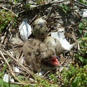
Colonial Nesting Waterbird Ecology
USGS is engaged in a variety of research aimed at understanding population dynamics in colonially nesting waterbirds of the Chesapeake Bay. Much of this work focuses on how focal species such as Common and Least Terns, Cattle and Snowy Egrets, and others respond to habitat restoration and management on Poplar Island, a large-scale effort lead by the U.S. Army Corps of Engineers and the Port of...

USGS Ecosystems Mission Area: Animal Welfare Assurance
The Ecosystems Mission Area (EMA) provides support for the Institutional Animal Care and Use Committees (IACUCs) at EMA science centers across the nation.

Integrated Hydrologic History of the American Southwest
Springs and wetlands in arid environments are bellwethers of aquifer health and water availability. These water-obligate ecosystems were dynamically sensitive to climatic fluctuations in the recent geologic past, especially to centennial- and decadal-scale warming events. Extreme events such as severe drought are projected to become more common throughout the Southwest in the coming years...