
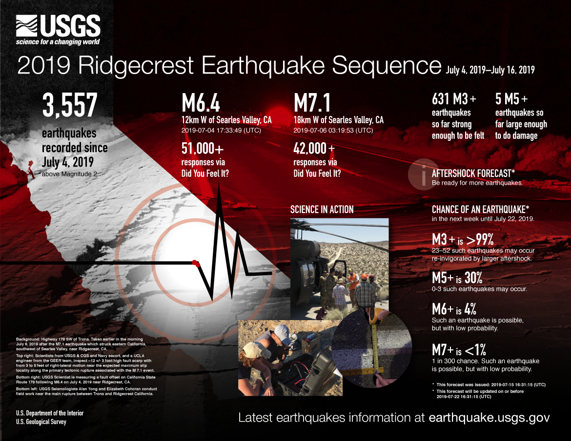
2019 Ridgecrest Earthquake Sequence: July 4, 2019–July 16, 2019

Detailed Description
3,557 earthquakes recorded since July 4, 2019 above Magnitude 2
M6.4 12km W of Searles Valley, CA
2019-07-04 17:33:49 (UTC)
51,000+ responses via Did You Feel It?
M7.1 18km W of Searles Valley, CA
2019-07-06 03:19:53 (UTC)
42,000+ responses via Did You Feel It?
631 M3+ earthquakes so far strong enough to be felt
5 M5+ earthquakes so far large enough to do damage
AFTERSHOCK FORECAST*
Be ready for more earthquakes.
CHANCE OF AN EARTHQUAKE*
in the next week until July 22, 2019.
M3+ is >99%
23–52 such earthquakes may occur re-invigorated by larger aftershock.
M5+ is 30%
0-3 such earthquakes may occur.
M6+ is 4%
Such an earthquake is possible, but with low probability.
M7+ is <1%
1 in 300 chance. Such an earthquake is possible, but with low probability.
* This forecast was issued: 2019-07-15 16:31:15 (UTC)
* This forecast will be updated on or before 2019-07-22 16:31:15 (UTC)
SCIENCE IN ACTION
Background: Highway 178 SW of Trona. Taken earlier in the morning July 6, 2019 after the M7.1 earthquake which struck eastern California, southwest of Searles Valley, near Ridgecrest, CA.
Top right: Scientists from USGS & CGS and Navy escort, and a UCLA engineer from the GEER team, inspect ~12 +/- 3 foot high fault scarp with from 3 to 5 feet of right-lateral motion near the expected maximum slip locality along the primary tectonic rupture associated with the M 7.1 event.
Bottom right: USGS Scientist is measuring a fault offset on California State Route 178 following M6.4 on July 4, 2019 near Ridgecrest, CA.
Bottom left: USGS Seismologists Alan Yong and Elizabeth Cohcran conduct field work near the main rupture between Trona and Ridgecrest California.
Latest earthquakes information at earthquake.usgs.gov
U.S. Department of the Interior
U.S. Geological Survey
Sources/Usage
Public Domain.