
Emperor geese gathered near the shoreline on Kodiak Island.
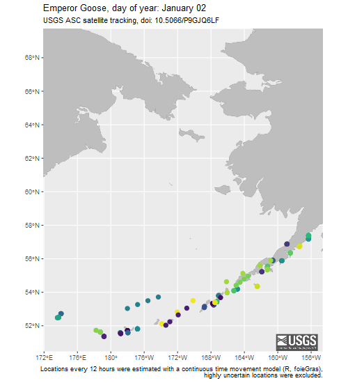
Available here are tracking data for the Emperor Goose, an endemic waterfowl species to the Bering Sea region that breeds primarily in western Alaska on the Yukon-Kuskokwim Delta and spends the winter in southwestern Alaska and throughout the Aleutian Islands. These data were collected to better understand the migratory patterns, winter habitat use, and annual survival of emperor geese.
Return to Ecosystems >> Wildlife Tracking Data Collection
USGS Alaska Science Center scientists collect data from wildlife tracking devices to: determine locations of animals throughout their annual cycles, understand patterns of habitat use, quantify time spent on various behaviors, and identify geographic areas repeatedly used by wildlife that may indicate sites of importance to species and populations. Tracking data from other wildlife species can be found at: https://doi.org/10.5066/P9VYSWEH
Tracking Maps
Media
Sources/Usage: Public Domain. View Media Details
(Credit: David Douglas, USGS)
Emperor Geese Tracking Maps
These webpages contain five different types of browse maps and other visualizations of the tracking data.
- Maps (Animated, Static, Interactive, and Google Earth)
- Summary graphs of the data: where, when, duration
- Waterfowl Tagged Animal Movement Explorer interactive visualization tool
- Note: These maps serve only as a depiction of the geographic content of the specific data provided and may be inappropriate for inferences and interpretation outside the intent of the original study. For example, maps may portray only certain ages, sexes, limited numbers of animals or variable tracking duration and start times that may limit inference for other questions. Users are advised to read the publication(s) and data set metadata associated with these maps to understand appropriate use and data limitations.
Data Packages
Argos Satellite Telemetry Data
These data packages contain the data collected from satellite transmitters attached to free-ranging animals. The packages include both raw and processed location and sensor data. The raw data includes data as originally retrieved from the Argos System. The processed data have been filtered for location plausibility, and sensor data have been decoded into standard measurement units. For most users, the processed data will be preferred.
NOTE: Processed data contains both plausible (DAF_Filter=0) and implausible (DAF_Filter=1) locations as indicated by the column “Location_DAF_filter”. Before using these data, we recommend excluding locations flagged as implausible or apply an alternative filtering method of your choice.
- Processed Data [Metadata] [Data Download, 6MB zip]
- Raw Data [Metadata] [Data Download, 10MB zip]
- README
- View ScienceBase Data Release
Light-Level Geolocator Data
This data package contains tables of raw light level data (calculated positions are not provided) obtained from light-level geolocators deployed on Emperor geese (Anser canagicus) on the Yukon-Kuskokwim Delta in western Alaska, 2015-2017.
- Raw Light-level Data [Metadata] [Data Download, 22.72MB zip]
- View ScienceBase Data Release
Suggested Citation
Uher-Koch, B.D., Schmutz, J.A., Hupp, J.W., Ely, C.R., and Douglas, D.C., 2021, Tracking data for Emperor Geese (Anser canagicus) (ver 2.0, April 2026): U.S. Geological Survey data release, https://doi.org/10.5066/P9GJQ6LF
Below are other science products associated with Emperor Geese.

Waterfowl Research
Scientists at the USGS Alaska Science Center have conducted research on waterfowl species (ducks, geese, and swans) in Alaska since the 1970s. Because Alaska is an international crossroads of migratory bird flyways, with millions of birds from Asia and North America breeding in Alaska each summer, USGS research has also taken place in adjacent countries (Russia, Japan, Canada, Mexico) and in the...

Goose Research
The USGS Alaska Science Center has had a focus on addressing science questions related to geese in Alaska for decades. Information on these species is critical because all are important resources for subsistence and sport hunters in the state and outside of Alaska where these birds spend the winter. The large majority of goose populations in Alaska breed on national wildlife refuges (managed by...
Below are multimedia items associated with Emperor Geese.

Emperor geese near Kodiak.
Emperor geese gathered near the shoreline on Kodiak Island.

Emperor geese standing at the shoreline near Kodiak
Emperor geese standing at the shoreline near KodiakEmperor geese standing at the shoreline near Kodiak.
Emperor geese standing at the shoreline near Kodiak
Emperor geese standing at the shoreline near KodiakEmperor geese standing at the shoreline near Kodiak.
Available here are tracking data for the Emperor Goose, an endemic waterfowl species to the Bering Sea region that breeds primarily in western Alaska on the Yukon-Kuskokwim Delta and spends the winter in southwestern Alaska and throughout the Aleutian Islands. These data were collected to better understand the migratory patterns, winter habitat use, and annual survival of emperor geese.
Return to Ecosystems >> Wildlife Tracking Data Collection
USGS Alaska Science Center scientists collect data from wildlife tracking devices to: determine locations of animals throughout their annual cycles, understand patterns of habitat use, quantify time spent on various behaviors, and identify geographic areas repeatedly used by wildlife that may indicate sites of importance to species and populations. Tracking data from other wildlife species can be found at: https://doi.org/10.5066/P9VYSWEH
Tracking Maps
Media
Sources/Usage: Public Domain. View Media Details
(Credit: David Douglas, USGS)
Emperor Geese Tracking Maps
These webpages contain five different types of browse maps and other visualizations of the tracking data.
- Maps (Animated, Static, Interactive, and Google Earth)
- Summary graphs of the data: where, when, duration
- Waterfowl Tagged Animal Movement Explorer interactive visualization tool
- Note: These maps serve only as a depiction of the geographic content of the specific data provided and may be inappropriate for inferences and interpretation outside the intent of the original study. For example, maps may portray only certain ages, sexes, limited numbers of animals or variable tracking duration and start times that may limit inference for other questions. Users are advised to read the publication(s) and data set metadata associated with these maps to understand appropriate use and data limitations.
Data Packages
Argos Satellite Telemetry Data
These data packages contain the data collected from satellite transmitters attached to free-ranging animals. The packages include both raw and processed location and sensor data. The raw data includes data as originally retrieved from the Argos System. The processed data have been filtered for location plausibility, and sensor data have been decoded into standard measurement units. For most users, the processed data will be preferred.
NOTE: Processed data contains both plausible (DAF_Filter=0) and implausible (DAF_Filter=1) locations as indicated by the column “Location_DAF_filter”. Before using these data, we recommend excluding locations flagged as implausible or apply an alternative filtering method of your choice.
- Processed Data [Metadata] [Data Download, 6MB zip]
- Raw Data [Metadata] [Data Download, 10MB zip]
- README
- View ScienceBase Data Release
Light-Level Geolocator Data
This data package contains tables of raw light level data (calculated positions are not provided) obtained from light-level geolocators deployed on Emperor geese (Anser canagicus) on the Yukon-Kuskokwim Delta in western Alaska, 2015-2017.
- Raw Light-level Data [Metadata] [Data Download, 22.72MB zip]
- View ScienceBase Data Release
Suggested Citation
Uher-Koch, B.D., Schmutz, J.A., Hupp, J.W., Ely, C.R., and Douglas, D.C., 2021, Tracking data for Emperor Geese (Anser canagicus) (ver 2.0, April 2026): U.S. Geological Survey data release, https://doi.org/10.5066/P9GJQ6LF
Below are other science products associated with Emperor Geese.
Waterfowl Research
Scientists at the USGS Alaska Science Center have conducted research on waterfowl species (ducks, geese, and swans) in Alaska since the 1970s. Because Alaska is an international crossroads of migratory bird flyways, with millions of birds from Asia and North America breeding in Alaska each summer, USGS research has also taken place in adjacent countries (Russia, Japan, Canada, Mexico) and in the...
Goose Research
The USGS Alaska Science Center has had a focus on addressing science questions related to geese in Alaska for decades. Information on these species is critical because all are important resources for subsistence and sport hunters in the state and outside of Alaska where these birds spend the winter. The large majority of goose populations in Alaska breed on national wildlife refuges (managed by...
Below are multimedia items associated with Emperor Geese.
Emperor geese near Kodiak.
Emperor geese gathered near the shoreline on Kodiak Island.
Emperor geese gathered near the shoreline on Kodiak Island.
Emperor geese standing at the shoreline near Kodiak
Emperor geese standing at the shoreline near KodiakEmperor geese standing at the shoreline near Kodiak.
Emperor geese standing at the shoreline near Kodiak
Emperor geese standing at the shoreline near KodiakEmperor geese standing at the shoreline near Kodiak.