
2025 USGS National Seismic Hazard Model for Puerto Rico and U.S. Virgin Islands Chance of Damaging Shaking Map
Detailed Description
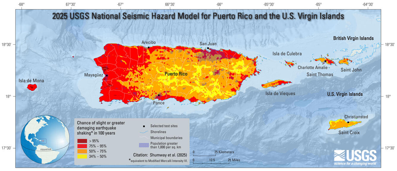
2025 USGS National Seismic Hazard Model for Puerto Rico and U.S. Virgin Islands Chance of Damaging Shaking Map; chance of slight-or-greater damaging earthquake shaking in 100 years (equivalent to Modified Mercalli Intensity VI).
Sources/Usage
Public Domain.
Suggested Citation:
Shumway, A.M., Milner, K.R., Altekruse, J.M., Herrick, J.A., Llenos, A.L., Michael, A.J., Haynie, K.L., Briggs, R.W., Jaiswal, K.S., and Powers, P.M., 2025, Datasets for the 2025 USGS National Seismic Hazard Model for Puerto Rico and the U.S. Virgin Islands: U.S. Geological Survey data release, https://doi.org/10.5066/P14ATJLJ.
Related

2025 PRVI NSHM
Posted in 2021: The U.S. Geological Survey (USGS) will publish an updated National Seismic Hazard Model (NSHM) for Puerto Rico and the U.S. Virgin Islands (PRVI) in 2025. The PRVI model was last updated in 2003.

2025 PRVI NSHM Update & Beyond Workshop
The National Seismic Hazard Model Project (NSHMP) will be presenting preliminary results of the 2025 Puerto Rico and U.S. Virgin Islands NSHM Update at this public workshop. On Day 1 we will focus on the 2025 PRVI update and on Day 2 we will present current data collection activities. These presentations will be technical but we encourage participation from users and stakeholders.

NSHM2025 PRVI Earthquake Geology Workshop
May 17, 2023, virtual
Related
2025 PRVI NSHM
Posted in 2021: The U.S. Geological Survey (USGS) will publish an updated National Seismic Hazard Model (NSHM) for Puerto Rico and the U.S. Virgin Islands (PRVI) in 2025. The PRVI model was last updated in 2003.
2025 PRVI NSHM Update & Beyond Workshop
The National Seismic Hazard Model Project (NSHMP) will be presenting preliminary results of the 2025 Puerto Rico and U.S. Virgin Islands NSHM Update at this public workshop. On Day 1 we will focus on the 2025 PRVI update and on Day 2 we will present current data collection activities. These presentations will be technical but we encourage participation from users and stakeholders.
NSHM2025 PRVI Earthquake Geology Workshop
May 17, 2023, virtual