
Asheville area monitoring stations

Detailed Description
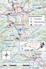
Asheville area monitoring stations
Sources/Usage
Public Domain.
Related

Monitoring water-quality and geomorphology in the French Broad River during I-26 construction
The North Carolina Department of Transportation (NCDOT) has partnered with the U.S. Geological Survey (USGS) to assess the water-quality and geomorphologic impacts resulting from the I-26 construction projects in western North Carolina. Streamflow, precipitation, and water-quality monitoring data, coupled with periodic assessments of geomorphology, will support the NCDOT construction-site...
Related
Monitoring water-quality and geomorphology in the French Broad River during I-26 construction
The North Carolina Department of Transportation (NCDOT) has partnered with the U.S. Geological Survey (USGS) to assess the water-quality and geomorphologic impacts resulting from the I-26 construction projects in western North Carolina. Streamflow, precipitation, and water-quality monitoring data, coupled with periodic assessments of geomorphology, will support the NCDOT construction-site...