
Attachment E: FY16 Status of 3DEP Quality Data

Detailed Description
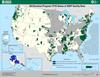
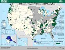
Map Title: 3D Elevation Program: FY16 Status of 3DEP Quality Data
Map of the United States and Territories showing the areal extent and quality level of planned, in progress, and existing publicly available lidar (ifsar in Alaska) data identified by the U.S. Interagency Elevation Inventory (USIEI) that meet 3DEP base-level specification as of June 2015. 3DEP baselevel specification data are defined as quality level 2 or better lidar data (ifsar in Alaska) and 8 years old or newer. The inventory was produced in partnership by the U.S. Geological Survey and the National Oceanic and Atmospheric Administration. While every attempt has been made to accurately inventory projects that are publicly available, some errors and omissions may occur.
Legend Explanation (From top down)
Dark Green - Meets 3DEP Base Level Specifications for lidar
Dark Blue - Meets 3DEP Base Level Specifications for IfSAR (Alaska)
Grey - Other Lidar Data
Light Yellow - No publicly available lidar data (IfSAR in Alaska)
Sources/Usage
Public Domain.
Broad Agency Announcements (BAAs)
The USGS issues a Broad Agency Announcement (BAA) that provides detailed information on how to partner with the USGS and other Federal agencies to acquire high-quality 3D data. Past BAA information may be found on the general BAA webpage.