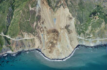
Big Sur landslide on May 20, 2017

Detailed Description
USGS air photo of the Mud Creek landslide, taken on May 27, 2017.
Sources/Usage
Public Domain.

Official websites use .gov
A .gov website belongs to an official government organization in the United States.
Secure .gov websites use HTTPS
A lock () or https:// means you’ve safely connected to the .gov website. Share sensitive information only on official, secure websites.
USGS air photo of the Mud Creek landslide, taken on May 27, 2017.
Public Domain.