
Day 2 IMNA block of 4 Images show working session

Detailed Description
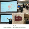
Day 2 - (L to R, clockwise) - An example of a hydrography data set visualization; Participants inside the workshop classroom; View of the wall sign out the National Air Photo Library; Robert Lugo (PAIGH) discussing dataset attributes.
Representatives from the national mapping agencies of Canada (Natural Resources Canada (NRCan)), Mexico (Instituto Nacional de Estadística y Geografía (INEGI)), and the United States (U.S. Geological Survey (USGS)), met in Ottawa, Canada to begin integrating data products from each country into an Integrated Map of North America (INMA). This workshop was facilitated and sponsored by the Pan American Institute of Geography and History (PAIGH), building upon successful past workshops in Central and South America.
Sources/Usage
Public Domain.