
December 9, 2022 — Mauna Loa Eruption Map

Detailed Description
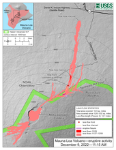
The Northeast Rift Zone eruption of Mauna Loa that began the evening of November 27, 2022, continues as of December 9, 2022 (twelfth full day). One active fissure, fissure 3, feeds lava flows downslope to the north. HVO field crews and USGS analysts have accurately mapped some of the most active flows, displayed in red here, along with older flows further uprift, in part of Mokuʻāweoweo caldera, and in the upper summit region southwest of the caldera. Lava flow length was measured by tracing the continuous active channel shown in yellow here and then extending the measurement to the distal lava flow extent measured in satellite data. The total area covered is less than reported in previous days due to refined mapping efforts.
Sources/Usage
Public Domain.