
Elevation-Derived Hydrography Data Acquisition Spec: Diff DEM 3 Sources
By NGP Standards and Specifications
April 2024 (approx.)
Detailed Description
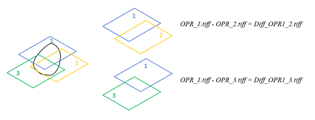
An elevation-derived hydrography project area shown in black with three overlapping source bare earth DEMs, OPR1, OPR2, and OPR3. OPR1 has the most recent data, so OPR2 is subtracted from OPR1 to create the first difference DEM, Diff_OPR1_2.tiff. Then OPR3 is subtracted from OPR1 to create the second difference DEM, Dirr_OPR1_3.tiff.
Sources/Usage
Public Domain.