
Endpoint of the Colorado River, Mexico

Detailed Description
Endpoint of the Colorado River, Mexico
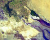
Less than 80 years ago, the mighty Colorado River flowed unhindered from northern Colorado through the Grand Canyon, Arizona, and Mexico before pouring into the Gulf of California. But as this NASA Earth Observatory satellite photo from September 2000 shows, irrigation and urban water needs now prevent the river from reaching its final destination. Rather, the Colorado River just disappears into the desert sands.
The Colorado River can be seen in dark blue at the topmost central part of this image. The river comes to an end just south of the multicolored patchwork of farmlands in the northwestern corner of the image and then fans out at the base of the Sierra de Juarez Mountains. Only about 10 percent of all the water that flows into the Colorado River makes it into Mexico and most of that is used by the Mexican people for farming.
Sources/Usage
Credit: NASA, Public domain
Related

Rivers, Streams, and Creeks
Related