
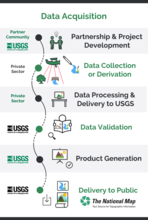
Figure 5: Chart showing phases of data acquisition, processing, and delivery to partners and the public for the 3D Hydrography Program (3DHP)

Detailed Description
Figure 5: Chart showing phases of data acquisition, processing, and delivery to partners and the public for the 3D Hydrography Program (3DHP). The phases are similar to those used for the 3D Elevation Program (3DEP). USGS, U.S. Geological Survey.
Sources/Usage
Public Domain.