
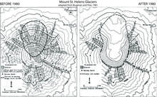
Glacier extent maps from before and after May 18, 1980.
By Volcano Hazards Program
1981 (approx.)

Detailed Description
Glacier extent maps on Mount St. Helens from before and after the May 18, 1980 eruption.
Sources/Usage
Public Domain.
Brugman and Post, 1981
Related

Glaciation at Mount St. Helens
Extensive glaciers covered Mount St. Helens and the surrounding vicinity during major Ice Ages of the past few hundred thousand years. Much of the geologic record of these events is sparse and incomplete, having been removed by erosion or buried by volcanic deposits.
Related
Glaciation at Mount St. Helens
Extensive glaciers covered Mount St. Helens and the surrounding vicinity during major Ice Ages of the past few hundred thousand years. Much of the geologic record of these events is sparse and incomplete, having been removed by erosion or buried by volcanic deposits.