
Hōlei Pali—Kīlauea Volcano's south flank
By Kīlauea

Detailed Description
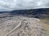
Aerial view of the Hōlei Pali along Kīlauea’s south flank. Hōlei Pali is a 400 meter (about 1300 ft) high escarpment along the Hilina fault system. During the Mauna Ulu eruption, lava flows descended the Pali between 1969 and 1974. Chain of Craters road is in view. USGS Photo by Sarah Conway taken June 21, 2019.
Sources/Usage
Public Domain.