
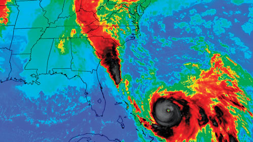
Hurricane Joaquin: Infrared satellite image, intense rainfall in SC.

Detailed Description
Selected Roadway High-Water Mark Data from Hurricane Joaquin Flooding, October 2015
Infrared satellite image of the intense rainfall in South Carolina during the morning of October 3, 2015 (from Feaster and others, 2015; National Aeronautics and Space Administration). Black areas show the highest rainfall amounts.
Sources/Usage
Related

Selected Roadway High-Water Mark Data from Hurricane Joaquin Flooding, October 2015
As part of the statewide response to the flooding, the USGS and S.C. Department of Transportation (SCDOT) conducted a cooperative study to collect high-water mark (HWM) data at 50 selected road crossings. The HWM elevations and descriptive data have been posted on the USGS Short-Term Network (STN). The STN is a national-scale application and database designed to support USGS event-based sensor...
Related
Selected Roadway High-Water Mark Data from Hurricane Joaquin Flooding, October 2015
As part of the statewide response to the flooding, the USGS and S.C. Department of Transportation (SCDOT) conducted a cooperative study to collect high-water mark (HWM) data at 50 selected road crossings. The HWM elevations and descriptive data have been posted on the USGS Short-Term Network (STN). The STN is a national-scale application and database designed to support USGS event-based sensor...