
Hurricane Maria high-water mark
By Communications and Publishing
2017 (approx.)

Detailed Description
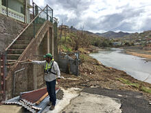
CAPTION: José Santiago-Saez, USGS hydrologic technician, flags a high-water mark in Comerio, Puerto Rico, from flooding on the Río de la Plata caused by Hurricane Maria. USGS Photo.
Sources/Usage
Public Domain.
Related

Puerto Rico Natural Hazards: Water Resources | Peligros naturales de Puerto Rico: Recursos de agua
The USGS monitors and studies water resources to deliver a wide range of data including streamflow conditions, groundwater information, lake and reservoir elevation, water quality, water use, and water availability, which can be accessed through the USGS National Water Dashboard. As of 2022, the USGS real-time water data network is comprised of 109 streamflow observation stations, 20 groundwater...
Related
Puerto Rico Natural Hazards: Water Resources | Peligros naturales de Puerto Rico: Recursos de agua
The USGS monitors and studies water resources to deliver a wide range of data including streamflow conditions, groundwater information, lake and reservoir elevation, water quality, water use, and water availability, which can be accessed through the USGS National Water Dashboard. As of 2022, the USGS real-time water data network is comprised of 109 streamflow observation stations, 20 groundwater...