
Hurricane Maria Impacting the Eastern Caribbean

Detailed Description
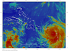
Colorized satellite imagery from 2017-09-19 15:00 UTC of Hurricane Maria impacting the Eastern Caribbean. Data provided by NOAA. Base image is intellectual property of NOAA and is used herein under license. Copyright Esri and its creator.
Sources/Usage
Public Domain.
Hurricane radar data provided by NOAA for Maria (2017). Base image is from the Geostationary Operational Environmental Satellites (GOES-13) spacecraft and was accessed through Multi-format Client-agnostic File Extraction Through Contextual HTTP (MCFECTH) that is maintained by The Satellite Data Services group at the University of Wisconsin-Madison Space Science and Engineering Center (SSEC) and is used herein under license. Copyright Esri and its licensors. All rights reserved.