
Hurricane Michael Pre- and Post-Storm Photo Comparisons - Mexico Beach

Detailed Description
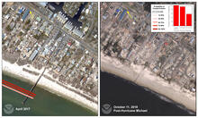
Location 5: Mexico Beach was inundated by 14 feet (~4 meters) of storm surge (according to a USGS water level sensor on the pier seen in this image) and battered by large waves and extreme winds, causing severe erosion of the dunes and complete destruction of the pier and many other buildings. Debris from destroyed buildings was transported far inland, an indicator that water was freely flowing over the island. The predicted probability of inundation here was only 58%, but the probability of overwash was 94%. Because water levels were elevated over several tide cycles, the dunes may have eroded before the storm came ashore, exacerbating the impact of the surge and waves to the dunes and infrastructure behind them.
Sources/Usage
Public Domain.