
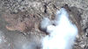
July 25, 2025 — UAS view of north vent

Detailed Description
This oblique aerial view of the north vent within Halema‘uma‘u crater was captured during a USGS Hawaiian Volcano Observatory UAS (uncrewed aircraft systems) flight on July 25, 2025. The aircraft was flying about 150 m (500 ft) above the vent—about the height of the crater rim—with the image captured looking down to the northeast. Though degassing was strong, no active lava was visible in the vent; brief glimpses through thick fume only showed lava rock rubble on the floor of the conduit. These UAS flights were conducted with the permission of Hawai‘i Volcanoes National Park, owing to the Hawaiian Volcano Observatory's mission to monitor active volcanoes in Hawaii, assess their hazards, issue warnings, and advance scientific understanding to reduce the impacts of eruptions. Unauthorized launching, landing, or operating of a UAS from or on lands and waters administered by the National Park Service is prohibited under 36 CFR Closures & Public Use. USGS photo by A. Kekahuna and M. Zoeller.
Sources/Usage
Public Domain.