
Kīlauea Volcano — Topography of Halema`uma`u

Detailed Description
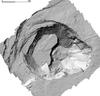
A photogrammetry survey of Kīlauea's summit by the U.S. Department of Interior Unmanned Aircraft Systems' (UAS) Kīlauea response team show the topography of Halema‘uma‘u as of June 8. Cracks through the former overlook parking lot (bottom of image) wrap around the east margin of Halema‘uma‘u; the once-popular overlook viewing area (closed since 2008 due to volcanic hazards associated with the former summit lava lake) has collapsed into the crater. New faulting and slumping are obvious on the crater's west side (left). The depth of the crater has increased by roughly 250 meters (820 feet) since early May. Limited UAS flights into the summit area are conducted with permission and in coordination with Hawai‘i Volcanoes National Park to collect quantitative and qualitative data needed for updated hazard assessments, all of which are shared with emergency managers.
Sources/Usage
Public Domain.